|
Research Ideas and Outcomes : Review Article
|
|
Corresponding author: Laura J Tilley (laura.tilley@smns-bw.de), Björn Berning (b.berning@landesmuseum.at), Boglárka Erdei (erdei.boglarka@nhmus.hu), Charalampos Fassoulas (fassoulas@nhmc.uoc.gr), Andreas Kroh (andreas.kroh@nhm-wien.ac.at), Jiří Kvaček (jiri.kvacek@nm.cz), Patricia Mergen (patricia.mergen@africamuseum.be), Caroline Michellier (caroline.michellier@africamuseum.be), C Giles Miller (g.miller@nhm.ac.uk), Michael Rasser (michael.rasser@smns-bw.de), Ralf T Schmitt (ralf-thomas.schmitt@mfn.berlin), Johanna Kovar-Eder (johanna.eder@smns-bw.de)
Received: 25 Feb 2019 | Published: 07 Mar 2019
© 2019 Laura Tilley, Björn Berning, Boglárka Erdei, Charalampos Fassoulas, Andreas Kroh, Jiří Kvaček, Patricia Mergen, Caroline Michellier, C Miller, Michael Rasser, Ralf Schmitt, Johanna Kovar-Eder
This is an open access article distributed under the terms of the Creative Commons Attribution License (CC BY 4.0), which permits unrestricted use, distribution, and reproduction in any medium, provided the original author and source are credited.
Citation: Tilley L, Berning B, Erdei B, Fassoulas C, Kroh A, Kvaček J, Mergen P, Michellier C, Miller C, Rasser M, Schmitt R, Kovar-Eder J (2019) Hazards and disasters in the geological and geomorphological record: a key to understanding past and future hazards and disasters. Research Ideas and Outcomes 5: e34087. https://doi.org/10.3897/rio.5.e34087
|
|
Abstract
Hazards and disasters have occurred throughout Earth's History and thus the geological record is an important resource for understanding future hazards and disasters. The Earth Science Group (ESG) of the Consortium of European Taxonomic Facilities (CETAF) carried out a “Hazard and Disaster Event Survey” to identify Earth Science collections in European museums that represent hazards and disasters throughout the geological record, and recent times. The aim is to use the collections within the survey as an educational and research resource that promotes the importance of museum collections for understanding past and future hazard and disaster events. The survey pinpointed a wide variety of hazards (e.g. earthquakes, volcanism, floods, impact events, etc.), representing a vast time span in Earth’s history (Proterozoic to Holocene), that are documented in the collections of the participating museums. Each hazard and disaster event has been described in terms of how they are preserved (e.g. fossil record or rock record), spatial scale, impact on life, and geological age. Here we showcase seven examples in detail which include well-known and less-known events from the survey that have contributed to our understanding of hazard and disaster processes and their impact on life. Also we present general conclusions and lessons learnt from the “Hazard and Disaster Event Survey”.
Keywords
Hazards, Disasters, Earth Science, Museum collections, Geological record, Fossils, Rocks, Minerals
Introduction
According to the
At present, there is widespread research (
The frequency and magnitude of natural processes such as volcanic eruptions, earthquakes, and tsunamis are not a consequence of climate change or human activity, but their potential impacts are worsened due to the increasingly exposed human population (
Hazards have occurred throughout Earth’s history. The geological and geomorphological records are important resources for understanding past and future hazards and disaster events. Earth scientists are able to study the rock record (sedimentology, petrology, geophysics and geochemistry) and the fossil record (the study of ancient fauna and flora) to investigate the processes of hazard events in order to improve forecasts and to anticipate the impact on life and its recovery afterwards.
This article has been developed by the Earth Science Group (ESG) of the Consortium of European Taxonomic Facilities (CETAF). The ESG consists of multiple museums and other research institutions within Europe, and its main purpose is to promote the importance of Earth Science collections in facilitating a better understanding and forecasting of current environmental and biodiversity issues. To help fulfil this purpose the ESG carried out a “Hazard and Disaster Event Survey” (presented in Suppl. material
- Increase awareness amongst the general public about hazards and how the geological and geomorphological records can be used to understand their impacts, and help learn lessons for the future.
- To facilitate collaboration between researchers working on such events and help improve the robustness of existing data and models.
The “Hazard and Disaster Event Survey” includes a wide variety of events that have affected Earth at different geographical scales (local, regional and global) such as earthquakes, tsunamis, flooding, marine anoxia, volcanic eruptions and landslides. The geological age of the different hazards recorded in the survey spans an interval from the Proterozoic (2500 to 541 million years ago) to the Holocene (11,700 years to present day). Here we showcase a small number of hazard and disaster events including well-known and less-known ones recorded in the survey that have contributed to our understanding of hazard processes and their impact on life. A summary table of the “Hazard and Disaster Event Survey” is presented at the end of this article in the conclusions. It should be noted that this publication demonstrates the potential of museum collections, and that the “Hazard and Disaster Event Survey” is an incomplete record but will continue to expand.
Fig.

Explanation of hazards mentioned
Volcanic eruption events: There are two main types of volcanic eruptions that have different hazards associated with them:
Explosive (e.g. Plinian and Vulcanian): These types of volcanic eruptions characteristically associated with evolved viscous magmas (e.g. andesitic and rhyolitic) with a high content of trapped volatiles, and when these magmas degas they produce explosive eruptions often projecting material into the stratosphere (
Non-explosive (e.g. Hawaiian, deep water submarine and Flood Volcanism): These types of eruptions are characterised by the outpouring of low viscosity magma (basaltic). Two examples of currently active volcanoes are Kilauea (Hawaii) and Nyiragongo (Democratic Republic of the Congo) (
Flood events: The definition of a flood is “an overflow of a large amount of water beyond its normal limits especially over what is normally dry land,” (
Impact event: “A type of extraterrestrial hazard caused by the collision of the Earth with a meteoroid, asteroid or comet” (
Salinity crisis: Occurs in bodies of water that are landlocked, without a continuous influx of fresh water and were evaporation exceeds inflow rate. This may result in the body of water becoming hypersaline (water with a higher salinity than sea water, and deposition of salt deposits) (
Marine anoxia: Marine anoxic events occur when there is an absence or low level of oxygen in the water column, this can be due to sluggish ocean circulation during times of warmer climates where the deep ocean is not ventilated by the sinking of oxygen rich surface waters (
Local and regional scale hazards and disasters
A local scale hazard/disaster event is defined here as one that affects a small geographical area (e.g. the size of a village, town or city). Whereas a regional scale hazard/disaster event affects a larger geographical area (e.g. a country or continent). Local and regional scale hazards/disasters of different types have been documented in the survey (see Suppl. material
Flood events
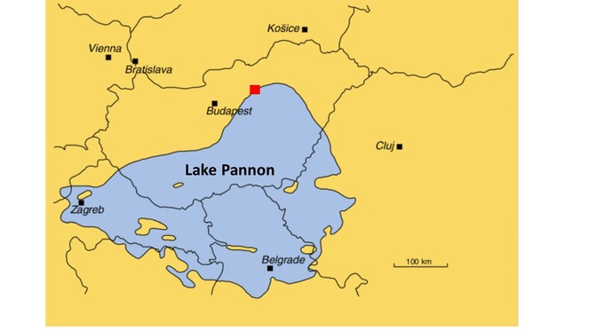
Bükkábrány drowned forest
Age: 7 million years ago, Miocene (
Modern location of event: Bükkábrány, north eastern Hungary
Location of collection: Hungarian Natural History Museum, Visitor Center of the Ipolytarnóc Fossils Nature Reserve
Preservation type: Palaeontology, fossil plants – tree stumps, fruits, seeds and leaves
Duration of event: Hundreds of years (
Impact on life: The rising water level of Lake Pannon drowned the swamp forests that grew around its edge.
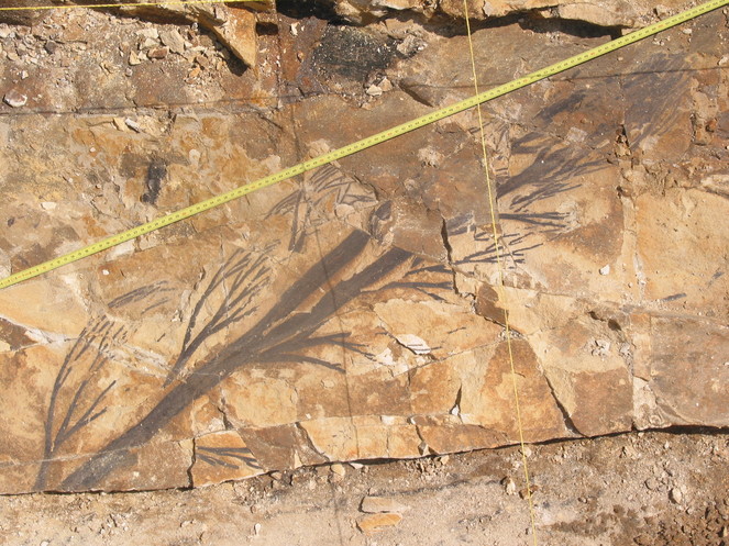
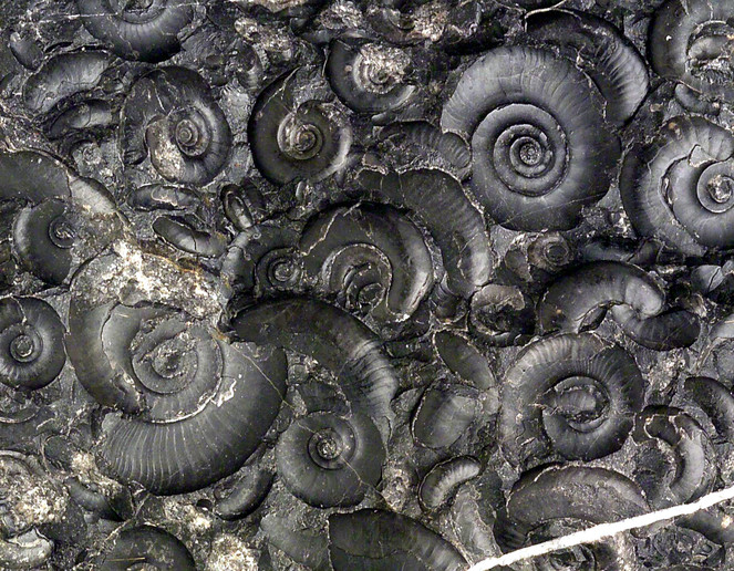
Background story: The Bükkábrány fossil forest is considered to be unique because it is the oldest forest preserved in situ (life position) (Fig.
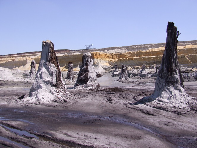
The fossil tree trunks are the remains of a warm temperate swamp forest that consisted of mainly large coniferous trees (tree types: Glyptostrobus and Taxodium) (
These fossil tree stumps are a valuable tool for reconstructing the ancient swamp forest ecology and the climate conditions under which it occurred through the study of the wood anatomy (e.g. tree ring analysis) (
Other examples of local and regional scale flood events
-
A mammal collection (including a human cranium of Homo steinheimensis) of Pleistocene age, originating from Germany (stratigraphy: Holstein Interglacial and Riss Glacial Stage), and housed at the State Museum of Natural History Stuttgart.
-
A vertebrate collection of late Miocene age, originating from Baltavár (Hungary), and housed at the Hungarian Natural History Museum.
Impact events (extraterrestrial projectiles)
Ries and Steinheim impact events
Age: 14.808 ±0.021 million years ago, Miocene (
Modern location of event: Ries: Nördlinger Ries, Bayern Baden-Württemberg, Germany; Steinheim: Swabian Alb, Bayern and Baden-Württemberg, Germany
Location of collection: Ries: Museum für Naturkunde Berlin, Natural History Museum Vienna; Steinheim: Museum für Naturkunde Berlin, State Museum of Natural History Stuttgart, Natural History Museum Vienna
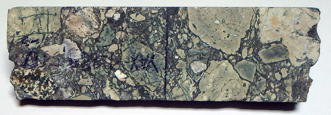
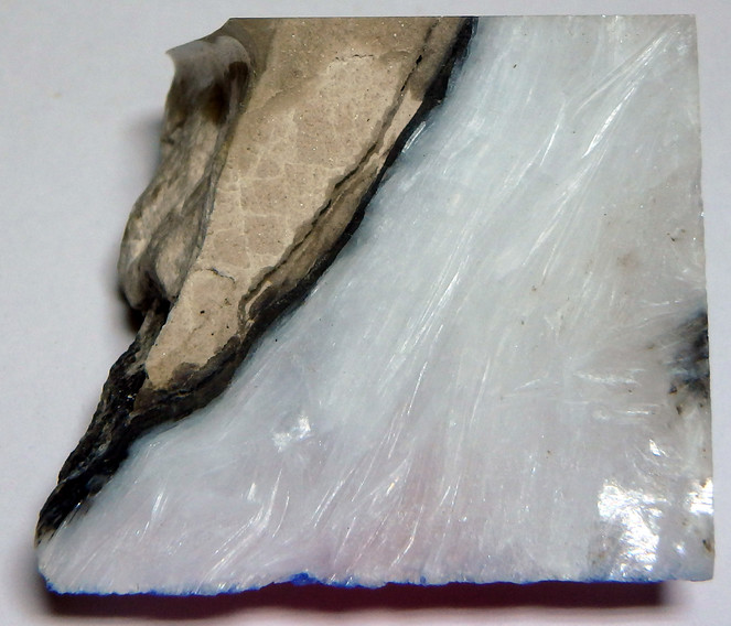
Preservation type: Ries: formation of a crater, impactites (lithic impact breccias, suevites, impact melt rocks, glass bomb, shatter cones and tektites), shock metamorphism of rocks and minerals (e.g. formation of high pressure phases, coesite, stishovite, diamond), lake sediments. Steinheim: formation of a crater, impactites (lithic impact breccias and shatter cones), ancient lake sediments, fossil fauna and flora.
Duration of event: The effect of the impacts were instant.
Impact on life: Both impacts only affected life that lived in close proximity to the target areas and presumably did not cause any species extinctions, and life recovered quickly afterwards (within decades) (
Background story:
Geological significance
The Ries and Steinheim impact events occurred 14.8 million years ago (
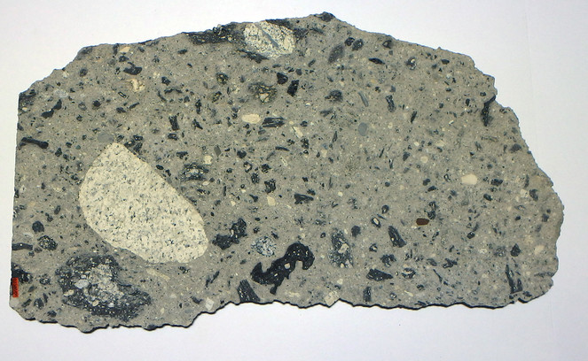
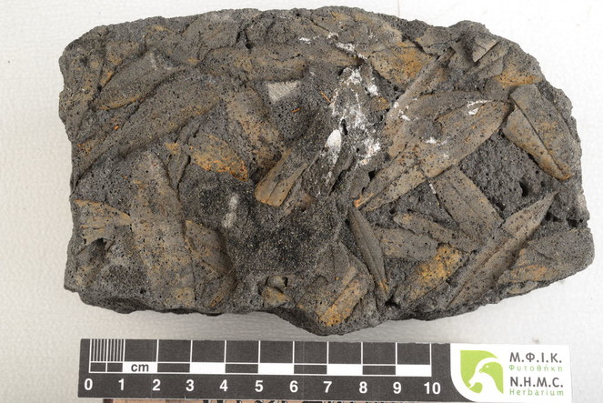
Suevite specimen from the Ries impact event, collected from a suevite deposit that is part of the ejecta blanket about 4 km east of the crater rim. Suevite is a rock type that consists of larger angular target rock fragments surrounded by a matrix of smaller fragments and grains that have been melted and recrystallised due to pressures caused by the impact. Specimen size: 27×15×0.5 cm. Museum für Naturkunde Berlin collection [Inventory number MFN_ PET_2008_02386], collected by M. Siebenschock, 1997, photo by R. T. Schmitt.
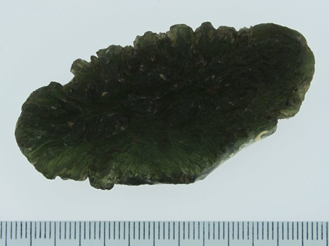
A tektite that originates from the distal ejecta (strewn field) of the Ries impact, found in the Czech Republic. Tektites from the Ries impact are called moldavites. Ruler at the bottom of the image = 6.6 cm [Inventory number NHMV_J677]. Photo courtesy of L. Ferrière, Natural History Museum Vienna.
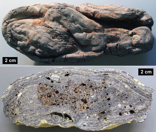
Melt bomb specimens. Top image: a complete specimen with typical surface features; bottom image: section of a bomb showing flow texture and numerous vesicles (Aumühle quarry, Ries impact structure) [Inventory numbers NHMV_J3852 & NHMV_O423]; Photo courtesy of L. Ferrière, Natural History Museum Vienna.
Palaeontological significance
The target areas were rich with forests and fauna (
During the middle Miocene, lakes formed within the impact craters and they became an ideal habitat for fish, ostracods and snails. In the case of Steinheim many were endemic to the lake (
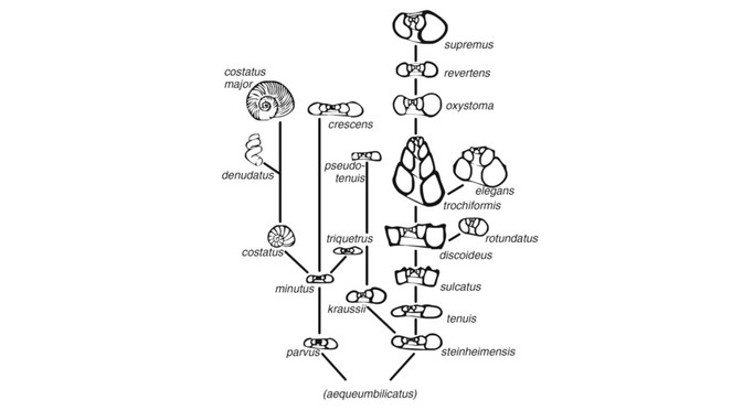
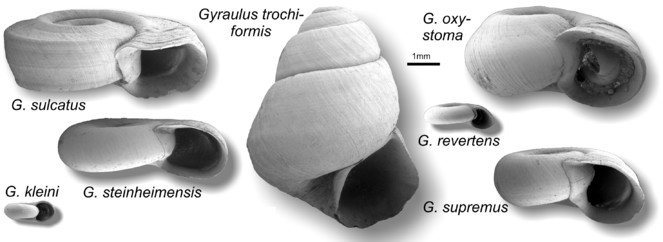
The factors/processes which caused endemism, and evolution of the snails in the ancient lake are still largely unknown. Evolution of the gastropods may have been triggered by environmental changes in the lake such as water level and chemical changes (
Other examples of local and regional scale impact events
- Impactite collection of Eocene age, originating from Popigai (Russia) and housed at the Museum für Naturkunde Berlin.
- Impact collection (proximal) of Late Triassic age (206.9 million years), originating from Rochechouart (France) and housed at the Natural History Museum Vienna.
- Impactite collection (distal - tektites) of Pleistocene age (0.77-0.78 million year), originating from the Australasian strewnfield and housed at the Natural History Museum Vienna.
Volcanic events
Santorini volcanic eruption
Age: 1614 ±30 B.C., Holocene (
Modern location of event: Santorini, Greece
Location of collection: Natural History Museum Crete
Preservation type: Fossil flora – olive leaves and branches, volcaniclastic rock
Duration of event: Days/hours
Impact on life: The Minoan civilisation was destroyed by a tsunami triggered by the collapse of the volcano sides.
Background story: The Santorini eruption is considered as one of the most violent in historic times, 10 times bigger than Krakatau (1883) in Indonesia. The Volcanic Explosively Index (VEI) for this eruption is estimated at 7 which makes the Santorini eruption one of the largest in the last 20,000 years (
Based on archaeological findings and relative dating, the eruption was for many decades considered to have happened around 1450-1500 B.C., and thus was considered the main reason for simultaneous collapse of the famous Minoan Civilisation and the destruction of its palaces (
The finding of fossilised leaves and branches of olive trees (Fig.
Analysis of the volcaniclastic rock units in which the olive leaves are preserved are important for understanding the processes and phases involved in the Santorini Eruption (Fig.
Carboniferous Plinian type eruption
Age: Pennsylvannian (323.2 ̶ 298.9 million years ago), Carboniferous (
Modern location of event: Radnice, Central Czech Republic
Location of collection: Natural History Museum Prague
Preservation type: Palaeontological, fossil flora, volcanic ash layers
Duration of event: Days
Impact on life: A swamp forest close to the volcanic center was destroyed as a result of being covered by ash.
Background story: The Lower Radnice Coal horizon contains well preserved swamp vegetation and it is overlain by a 40–60 cm thick layer of coarse volcaniclastic sediments (containing a lot of feldspar) (
Other examples of local and regional scale volcanic events
- A recent study by
Petrone et al. (2016) (Natural History Museum London) on the chemical analysis of zoned crystals within igneous rock from Stromboli (Italy) has helped further the understanding of pre-eruptive magmatic processes, which is an important step towards being able to predict volcanic eruptions in the future. Although the paper does not mention museum collections it is an example of how museum archived rock samples could be re-studied using new techniques (Pers Comm. G. Miller, April 2018). - Regional rock collections of Quaternary age (regional scale event), originating from Campi Flegrei, Vesuvius/Monte Somme (Italy), housed at the Museum für Naturkunde Berlin (Germany).
- Plant fossils, of early Miocene age (local scale event), originating from Ipolytarnóc (Hungary), housed at the Hungarian Natural History Museum.
- The Royal Museum for Central Africa (Belgium) is studying the eruptive history of the Nyamulagira and Nyiragongo volcanoes located close to Goma city (Democratic Republic of Congo), at the border with Rwanda. Intensive field work and radiocarbon dating of rock samples from the museum’s Earth science collection provided new evidence of the explosive activity of some volcanic cones identified in the region (
Smets et al. 2013 ,Smets et al. 2015 ,Poppe et al. 2016 ).
Salinity crisis event
Messinian salinity crisis
Age: Messinian (7.2–5.3 million years ago), Miocene (
Modern location of event: Mediterranean Sea
Location of collection: Natural History Museum Crete
Preservation type: Palaeontology (marine and terrestrial organisms), mineralogical (evaporite minerals)
Duration of event: 600,000 years
Impact on life: Extinction of marine organisms, turnover of terrestrial fauna. The collections identified here only show evidence of life prior to the event.
Background story: The Messinian is the last stage of the Miocene Epoch, which lasted from 7.2 to 5.33 million years ago. For the Mediterranean this period is related to one of the most catastrophic geological and meteorological events, the Messinian salinity crisis, which was caused by the isolation of the basin from the Atlantic Ocean (
Following the closure of the marine connections to the Indian Ocean in the early Miocene (
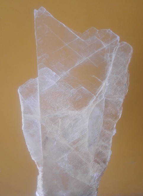
The crisis ended 5.33 million years ago when new straits opened in the Gibraltar area and a huge flooding event took place. Nowadays evaporitic minerals dating back to the Messinian salinity crisis can be found in Crete (Fig.
Global scale hazards and disasters
Global events recorded in the CETAF members’ collections include, impact events, volcanism, and marine anoxia (see Suppl. material
Marine anoxia event
Carnian pluvial episode (CPE)
Age: Carnian (237–228.4 million years ago), Triassic (
Modern location of event: Aşağiyaylabel locality–Taurus Mountains, southwest Turkey
Location of collection: Natural History Museum Vienna
Preservation type: Fossils – mass ammonite assemblages
Duration of Event: Millions of years (
Impact on Life: The CPE caused widespread anoxic conditions in the oceans and thus caused widespread mortality of marine organisms in particular reef forming organisms (
Background Story: The Carnian Pluvial Episode (CPE) refers to a time of global climate change from arid conditions that characterised most of the Triassic to high humidity and mega-monsoonal conditions (
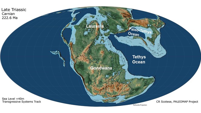
Fig.
Other examples of global scale marine anoxia events
- Collection of Mesozoic vertebrates, including fishes of Carnian age (237–228.4 million years ago), Triassic, originating from Raibl in Austria, housed e.g. at the State Museum of Natural History Stuttgart.
- Conodont collections of Late Devonian age (383–359 million years ago), housed at Senckenberg Institute, Frankfurt.
- Collection of Mesozoic vertebrate samples of Toarcian age (183–174 million years ago), Jurassic, housed at the State Museum of Natural History Stuttgart.
Impact events (extraterrestrial projectiles)
Cretaceous/Paleocene impact event (Chicxulub)
Age: 66 million years ago, Cretaceous/Paleocene (
Modern location of event: Impact location: Chicxulub, Yucatan, Mexico; knock-on effects were global
Location of collection: Museum für Naturkunde Berlin, Natural History Museum Vienna, Swedish Museum of Natural History, Natural History Museum London, National Museum of Natural Science Madrid
Preservation type: Formation of a crater, ca. 180 km in diameter (buried by younger sediments), impactites in the crater (Fig.
Suevite specimen from ICDP – drill core Yaxcopoil-1 (2001–2002), depth 889.51 m, Chixulub impact crater, Yucatan peninsula, Mexico. The suevite consists of melted and recrystallised fragments of the target rock. Specimen length 9.5 cm. Museum für Naturkunde Berlin collection [Inventory number MFN_PET_2008_00058], photo by R. T. Schmitt.
Duration of event: The aftermath effects of the impact possibly lasted hundreds to thousands of years.
Impact on life: Around 76% animal species (land and marine) became extinct (
Background story: The Cretaceous/Paleocene impact event is associated with one of the most well-known extinction events in Earth’s history because a substantial number of organisms on Earth became extinct, including the dinosaurs (
There was an initial cooling phase that was caused by sulphate gases and dust prohibiting penetration of sunlight, and as a result primary food producers like plants and marine plankton could not photosynthesise, leading to the collapse of the food chain (
Other examples of global scale impact events
- Core samples from the Sudbury Impact Structure (1849 million years old,
Davis 2008 ); ca. 260 km max. diameter originally,Planetary and Space Science Centre (2018) , housed e.g. at the University of Hamburg (Institute of Geology). - Impactite collection from the Vredefort Impact Structure (2023 ±4 million years old,
Kamo et al. (1996) ; ca. 160 km diameter today [ca. 250 ̶ 300 km originally],Planetary and Space Science Centre (2018) , housed at the Museum für Naturkunde Berlin and the Natural History Museum Vienna.
Conclusions/what lessons can we learn for the future
The “Hazard and Disaster Events Survey”, which is summarised as a table below, reveals a wide range of different hazard and disaster event types recorded in the geological record that are documented in museum collections. This review presents seven exemplar hazard and disaster events detailing their location, duration, geographical scale, impact on life, and causal mechanisms if known. It highlights the potential value of studying the geological record for furthering our understanding of the causes and impacts of hazards and disasters at different geographical scales (regional and global scale). Furthermore it emphasises the importance of museum collections as a resource for hazard event research. Museum collections contain unique rock and fossil samples that have been archived from localities that are sometimes no longer accessible or may not be in the future; thus they allow the continued study of past hazard events and have the potential for new data to be obtained. Below are listed the conclusions and future lessons derived from the “Hazard and Disaster Event Survey” (presented in Suppl. material
- The fossil and rock record can be useful in constraining dates when events occurred and thus help distinguish consequences of the hazards and disasters. For example, olive leaves and branches preserved during the Santorini eruption event helped constrain the date of the eruption, and that it triggered a tsunamis that initiated the demise of the Minoan civilisation.
- Fossils can be useful tools for investigating causal mechanisms of events. For instance potential environmental causes of the Bükkábrány flood event (e.g. climatic or tectonic) may in future be clarified by studying the climate signals stored in the fossil wood anatomy (e.g. growth ring analysis).
- In many cases regardless of the geographical scale of an event, life is present before and afterwards, however the type of life present might have changed (e.g. different plant species).
- Not all hazards in Earth’s history have caused massive destruction to life; in some cases they have helped biodiversity and species evolution. The Steinheim impact event created a crater in which a long lasting lake developed and became a habitat for different types of organisms (e.g. gastropod), which evolved into new endemic species (only found in this lake).
- Some regional or global scale hazards and disasters such as explosive volcanism (with ash clouds), marine anoxia and flood events allow for the excellent preservation of fossils. For example ash fall from a Carboniferous Plinian eruption covered swamp vegetation and prevented it from decay. Another example is the Bükkábrány drowned forest. Excellently preserved fossils allow for more detailed reconstructions of past environments on Earth and help gain insight into the causal mechanisms and environmental impacts of some hazards.
- Many types of hazards and disasters that are recorded in the geological record also occur frequently in present times (e.g. volcanism, tsunamis, earthquakes and impacts).
- Some hazards and disasters have not occurred for millions/thousands/hundreds of years but are a risk in the future e.g. widespread marine anoxia, sea level rise, and climate change. A large scale salinity crisis like the one that occurred in the Messinian has not occurred in present times but it is important to understand the mechanisms that caused such an event because it may happen in the near future.
- Hazards such as volcanic eruptions, impact events and flooding can modify significantly life at local, regional and global scale.
Acknowledgements
A special thank you to the museums/institutes in the Earth Science Group (ESG) of the Consortium of European Taxonomic Facilities (CETAF) that have contributed to the “Hazard and Disaster Event Survey” and supported the development of this publication: Estonian Geological collections, Fossil World Vienna, Hungarian Natural History Museum, Museum für Naturkunde Berlin, National Museum of Natural Sciences Madrid, Natural History Museum of Crete, Natural History Museum London, Natural History Museum Prague, Natural History Museum Vienna, Natural History Museum Sweden, Royal Museum for Central Africa, State Museum of Natural History Stuttgart, Senckenberg Institutes (Frankfurt, Görlitz, Dresden, Weimar), Center of Natural History Hamburg University (Institute of Geology). Ludovic Ferrière and Alexander Lukeneder (Natural History Museum Vienna) are gratefully acknowledged for providing photographs. Thank you to Christian Koeberl (Natural History Museum Vienna) for providing feedback and advice on an earlier version of this manuscript. Finally a thank you to CETAF for covering publication costs for this manuscript.
Author contributions
C.F., J.K-E., A.K., P.M., M.R. and J.K. Initially presented the idea of the "Hazard and Disaster Event Survey" for outreach purposes.
C.F., J.K-E., A.K., P.M., M.R., L.J.T., developed the idea of using the results from the "Hazard and Disaster Event Survey" to produce a publication aimed at the general public and natural science community.
L.J.T., analysed the results of the "Hazard and Disaster Event survey", selected the collection examples that have been used in the manuscript; approached Earth Science Group (of CETAF) members for information/images on examples; read/researched literature and evaluated information on the selected collections and the hazard/disasters that they documented. Also planned the content/layout of the manuscript, with the support of C.F., J.K-E., A.K., P.M., M.R. and R.T.S.
L.J.T., wrote the majority of the manuscript with the support of J.K-E., A.K., P.M., C.F., B.B, C.G.M., R.T.S., and C.M.
M.R., developed the idea of Figure 1. which is a visualisation of the "Hazard and Disaster Event Survey" results. L.J.T. further developed the idea and designed Figure 1. with the support of J.K-E. and M.R.
C.F., contributed writing for the Santorini volcanic eruption and Messinian salinty crisis, which was edited and further expanded on by L.J.T.
B.B., Contributed writing for the Messinian salinity crisis.
J.K. Contributed writing for the Carboniferous plinian type eruption; edited by L.J.T.
B.B., B.E., C.F., A.K. J.K., C.M., C.G.M, M.R., R.T.S., provided information, references, expertise, and figures for the selected collections.
Conflicts of interest
The authors declare no conflict of interest.
References
-
Vertebrate Evolution and Extinction on Western and Central Mediterranean Islands.Tropics10(1):103‑123. https://doi.org/10.3759/tropics.10.103
-
Extraterrestrial Cause for the Cretaceous -Tertiary Extinction.Science208:1095‑1108. https://doi.org/10.1126/science.208.4448.1095
-
Arizona State University Center for Meteorite Studies. https://meteorites.asu.edu/meteorites/meteorite-appearance. Accessed on: 2019-1-07.
-
Types of volcanic eruptions. https://geology.com/volcanoes/types-of-volcanic-eruptions/. Accessed on: 2018-2-08.
-
Single-Station Seismo-Acoustic Monitoring of Nyiragongo's Lava Lake Activity (D.R. Congo).Frontiers in Earth Science6https://doi.org/10.3389/feart.2018.00082
-
The cheilostome bryozoan fauna from the Late Miocene of Niebla (Guadalquivir Basin, SW Spain): environmental and biogeographic implications.Mitteilungen aus dem Geologisch-Paläontologischen Institut der Universität Hamburg,Hamburg,156pp.
-
The Ries and Steinheim Meteorite Impacts and their Effect on Environmental Conditions in Time and Space. In: Buffetaut E, Koeberl C (Eds)Geological and Biological Effects of Impact Events.Springer,Berlin, Heidelberg. https://doi.org/10.1007/978-3-642-59388-8_10
-
On the causes of mass extinctions.Palaeogeography, Palaeoclimatology, Palaeoecology478:3‑29. https://doi.org/10.1016/j.palaeo.2016.11.005
-
Large igneous provinces and mass extinctions: An update. In: Keller G, Ker A (Eds)Volcanism, Impacts, and Mass Extinctions: Causes and Effects.505.Geological Society of Americahttps://doi.org/10.1130/2014.2505(02)
-
Baby, it's cold outside: Climate model simulations of the effects of the asteroid impact at the end of the Cretaceous.Geophysical Research Letters44(1):419‑427. https://doi.org/10.1002/2016gl072241
-
The Steinheim Basin impact crater (SW-Germany) – Where are the ejecta?Icarus250:529‑543. https://doi.org/10.1016/j.icarus.2014.12.026
-
The International Disaster Database. https://www.emdat.be/. Accessed on: 2018-6-20.
-
possible Late Miocene fossil forestPaleoPark in Hungary. In: Lipps JH, Grainer BR (Eds)PaleoParks - The protection and conser-vation of fossil sites worldwide.Carnets de Géologie / Notebooks on Geolog,Brest.
-
Carbon isotope records reveal synchronicity between carbon cycle perturbation and the “Carnian Pluvial Event” in the Tethys realm (Late Triassic).Global and Planetary Change127:79‑90. https://doi.org/10.1016/j.gloplacha.2015.01.013
-
Sub-million-year age resolution of Precambrian igneous events by thermal extraction–thermal ionization mass spectrometer Pb dating of zircon: Application to crystallization of the Sudbury impact melt sheet.Geology36(5):383‑386. https://doi.org/10.1130/g24502a.1
-
Perceptions of hazard and risk on Santorini.Journal of Volcanology and Geothermal Research137(4):285‑310. https://doi.org/10.1016/j.jvolgeores.2004.06.002
-
Diversification of mammals from the Miocene of Spain.Paleobiology40(02):197‑221. https://doi.org/10.1666/13043
- https://en.oxforddictionaries.com/. Accessed on: 2018-2-08.
-
The buried Miocene forest at Bükkábrány, Hungary.Review of Palaeobotany and Palynology155:69‑79. https://doi.org/10.1016/j.revpalbo.2009.01.003
-
Late Miocene plant remains from Bukkabrany, Hungary.Studia Botanica Hungarica42:135‑151.
-
Santorini Eruption Radiocarbon Dated to 1627-1600 B.C.Science312(5773):548‑548. https://doi.org/10.1126/science.1125087
-
The Minoan Eruption of Santorini around 1613 B.C. and its consequences.In: Meller H, Bertemes F, Bork HR, Risch R (Eds)1600 – Kultureller Umbruch im Schatten des Thera-Ausbruchs?9.Tagungen des Landesmuseums für Vorgeschichte Halle,Halle (Saale),37-48pp.
-
Biotic and abiotic response to palaeoenvironmental changes at Lake Pannons' western margin (Central Europe, Late Miocene).Palaeogeography, Palaeoclimatology, Palaeoecology312:181‑193. https://doi.org/10.1016/j.palaeo.2011.10.010
-
Identification of fossil trunks from Bükkábrány newly installed in the Visitor Centre of the Ipolytarnóc Fossils Nature Reserve (Novohrad – Nógrád Geopark) in Northern Hungary.Acta Universitatis Agriculturae et Silviculturae Mendelianae Brunensis58(5):117‑122. https://doi.org/10.11118/actaun201058050117
-
Biogeographic responses to geodynamics: A key study all around the Oligo–Miocene Tethyan Seaway.Zoologischer Anzeiger - A Journal of Comparative Zoology246(4):241‑256. https://doi.org/10.1016/j.jcz.2007.05.001
-
Caldera development during the Minoan eruption, Thira, Cyclades, Greece.Journal of Geophysical Research89:8441‑8462. https://doi.org/10.1029/jb089ib10p08441
-
Bieträge zur Kenntnis des Süßwasserkalkes von Steinheim. Unpublished Dissertation.University of Tübingen,Tübingen.
-
Über Planorbis multiformis im Steinheimer Süßwasserkalk.Monatsberichte der Königlich Preusischen Akademie der Wissenschaften zu Berlin1866:474‑504.
-
Extreme natural hazards: population growth, globalization and environmental change.Philosophical Transactions of the Royal Society A: Mathematical, Physical and Engineering Sciences364(1845):1875‑1888. https://doi.org/10.1098/rsta.2006.1803
-
Climate Change 2014: Synthesis Report. In: Team CW, Pachauri RK, Meyer LA (Eds)Contribution of Working Groups I, II and III to the Fifth Assessment Report of the Intergovernmental Panel on Climate Change.IPCC,Geneva,151pp.
-
Site of asteroid impact changed the history of life on Earth: the low probability of mass extinction.Scientific Reports7(1). https://doi.org/10.1038/s41598-017-14199-x
-
A 2.023 Ga age for the Vredefort impact event and a first report of shock metamorphosed zircons in pseudotachylitic breccias and Granophyre.Earth and Planetary Science Letters144:369‑387. https://doi.org/10.1016/s0012-821x(96)00180-x
-
The miocene Bükkabrány fossil forest in Hungary - field observations and project outline.Hantkeniana6:229‑244.
-
Ocean Deoxygenation in a Warming World.Annual Review of Marine Science2(1):199‑229. https://doi.org/10.1146/annurev.marine.010908.163855
-
Revision of the plant assemblage of Steinheim am Albuch (Baden-Württemberg, Germany, middle Miocene, reference locality of Mammal Neogene Zone MN 7).Bulletin of Geosciences93(4):1‑38. https://doi.org/10.3140/bull.geosci.1695
-
Chronology, causes and progession of the Messinian salinity crisis.Nature400:652‑655. https://doi.org/10.1038/23231
-
The Chicxulub impact event and its environmental consequences at the Cretaceous–Tertiary boundary.Palaeogeography, Palaeoclimatology, Palaeoecology255:4‑21. https://doi.org/10.1016/j.palaeo.2007.02.037
-
Flood hazard assessment for extreme flood events.Natural Hazards84(3):1569‑1599. https://doi.org/10.1007/s11069-016-2501-z
-
Taphonomic implications from Upper Triassic mass flow deposits: 2-dimensional reconstructions of an ammonoid mass occurrence (Carnian, Taurus Mountains, Turkey).Geologica Carpathica65(5):342‑367. https://doi.org/10.2478/geoca-2014-0024
-
A delayed carbonate factory breakdown during the Tethyan-wide Carnian Pluvial Episode along the Cimmerian terranes (Taurus, Turkey).Facies58(2):279‑296. https://doi.org/10.1007/s10347-011-0279-8
-
Paleogeographic evolution of the Late Miocene Lake Pannon in Central Europe.Palaeogeography, Palaeoclimatology, Palaeoecology147:151‑167. https://doi.org/10.1016/s0031-0182(98)00155-2
-
Volcanic products of the Central Bohemian Carboniferous.Sbornik geologickych vëd, Geologie24:73‑104.
-
Hypersaline Environments. In: Bell EM (Ed.)Life at Extreme Environments, Organisms and Stratergies for Survival.CABI,Wallingford.
-
Morphology and population of binary asteroid impact craters.Earth and Planetary Science Letters363:121‑132. https://doi.org/10.1016/j.epsl.2012.12.033
-
Geometry of the Altenberg-Teplice Caldera revealed by the borehole and seismic data in its Czech part.Journal of Geosciences55:217‑229. https://doi.org/10.3190/jgeosci.071
-
Volcanoes, Magma, and Volcanic Eruptions.http://www.tulane.edu/~sanelson/Natural_Disasters/volcan&magma.htm. Accessed on: 2018-2-08.
-
A Middle Pennsylvanian (Bolsovian) peat-forming forest preserved in situ in volcanic ash of the Whetstone Horizon in the Radnice Basin, Czech Republic.Review of Palaeobotany and Palynology155:234‑374. https://doi.org/10.1016/j.revpalbo.2009.03.002
-
Composition and structure of an in situ middle Pensylvanian peat-forming plant assemblage buried in volcanic ash, Radnice Basin (Czech Republic.PALAIOS24(11):726‑746. https://doi.org/10.2110/palo.2008.p08-128r
-
T0 peat-forming plant assemblage preserved in growth position by volcanic ash-fall: A case study from the Middle Pennsylvanian of the Czech Republic.Bulletin of Geosciences89:773‑818. https://doi.org/10.3140/bull.geosci.1499
-
Pre-eruptive magmatic processes re-timed using a non-isothermal approach to magma chamber dynamics.Nature Communications7:1‑11. https://doi.org/10.1038/ncomms12946
-
Earth Impact Database. http://www.passc.net/EarthImpactDatabase/. Accessed on: 2018-9-10.
-
Holocene phreatomagmatic eruptions alongside the densely populated northern shoreline of Lake Kivu, East African Rift: timing and hazard implications.Bulletin of Volcanology78(11):78‑82. https://doi.org/10.1007/s00445-016-1074-8
-
Darwin's dilemma: The Steinheim snails' point of view.Zoosystematics and Evolution89(1):13‑20. https://doi.org/10.1002/zoos.201300002
-
Evolution in isolation: the Gyraulus species flock from Miocene Lake Steinheim revisited.Hydrobiologia739(1):7‑24. https://doi.org/10.1007/s10750-013-1677-4
-
Predation on freshwater snails in Miocene Lake Steinheim: a trigger for intralacustrine evolution?Lethaia47(4):524‑532. https://doi.org/10.1111/let.12078
-
The Carnian Humid Episode of the late Triassic: a review.Geological Magazine153(02):271‑284. https://doi.org/10.1017/s0016756815000424
-
A high-precision 40Ar/39Ar age for the Nördlinger Ries impact crater, Germany, and implications for the accurate dating of terrestrial impact events.Geochimica et Cosmochimica Acta220:146‑157. https://doi.org/10.1016/j.gca.2017.09.036
-
Atlas of Middle & Late Permian and Triassic Paleogeographic Maps, maps 43–48 from Volume 3 of the PALEOMAP Atlas for ArcGIS (Jurassic and Triassic) and maps 49–52 from Volume 4 of the PALEOMAP PaleoAtlas for ArcGIS (Late Paleozoic).Mollweide Projection, PALEOMAP Project.Evanston, I.
-
Detailed multidisciplinary monitoring reveals pre- and co-eruptive signals at Nyamulagira volcano (North Kivu, Democratic Republic of Congo).Bulletin of Volcanology76:78. https://doi.org/10.1007/s00445-013-0787-1
-
Spatio-temporal dynamics of eruptions in a youthful extensional setting: Insights from Nyamulagira Volcano (D.R. Congo), in the western branch of the East African Rift.Earth-Science Reviews150:305‑328. https://doi.org/10.1016/j.earscirev.2015.08.008
-
Patterns of extinction and biodiversity in the fossil record.The Earth System: Biological and Ecological Dimensions of Global Environmental Change2:297‑301.
-
A Tomographic View on Western Mediterranean Geodynamics.The TRANSMED Atlas. The Mediterranean Region from Crust to Mantle. https://doi.org/10.1007/978-3-642-18919-7_2
-
Versuch einer geognostisch-botanischen Darstellung der Flora der Vorwelt.In Kommission im Deutschen Museum, in Leipzig bei Fr. Fleischer.
-
Active Andean volcanism: its geologic and tectonic setting.Revista geológica de Chile31(2):161‑206. https://doi.org/10.4067/s0716-02082004000200001
-
Modeling the Ries-Steinheim impact event and the formation of the moldavite strewn field.Meteoritics & Planetary Science37(12):1893‑1907. https://doi.org/10.1111/j.1945-5100.2002.tb01171.x
-
UNISDR terminology on disaster risk reduction. https://www.unisdr.org/we/inform/publications/7817. Accessed on: 2018-8-21.
-
Summary of volcanic hazards from Kīlauea eruptions. https://volcanoes.usgs.gov/volcanoes/kilauea/extra/hazards.pdf. Accessed on: 2018-8-21.
-
Late Miocene turnover in the Spanish mammal record in relation to palaeoclimate and the Messinian Salinity Crisis.Palaeogeography, Palaeoclimatology, Palaeoecology238:228‑246. https://doi.org/10.1016/j.palaeo.2006.03.030
-
Magma sources involved in the 2002 Nyiragongo eruption, as inferred from an InSAR analysis.Journal of Geophysical Research: Solid Earth117:1‑20. https://doi.org/10.1029/2011jb008257
Supplementary material
Presence data of Earth Science Museum Collections in Europe that document hazard and disaster events. This is an incomplete dataset and will continue to expand.
Download file (11.40 kb)