|
Research Ideas and Outcomes : Software Description
|
|
Corresponding author: Robert J. Smith (r.j.smith@kent.ac.uk)
Received: 30 Jan 2019 | Published: 31 Jan 2019
© 2019 Robert Smith
This is an open access article distributed under the terms of the Creative Commons Attribution License (CC BY 4.0), which permits unrestricted use, distribution, and reproduction in any medium, provided the original author and source are credited.
Citation: Smith R (2019) The CLUZ plugin for QGIS: designing conservation area systems and other ecological networks. Research Ideas and Outcomes 5: e33510. https://doi.org/10.3897/rio.5.e33510
|
|
Abstract
Background
Systematic conservation planning is the most widely used approach for designing conservation area systems and other types of ecological network. Thus, user-friendly decision support tools are needed to guide conservation planners when using this approach.
New information
CLUZ is a QGIS plugin that can be used for on-screen conservation planning and also acts as an interface for Marxan, the most widely used spatial conservation prioritisation software package.
Keywords
Systematic conservation planning, Marxan, gap analysis, spatial conservation prioritisation, protected areas, OECMs
Introduction
One of the most important ways of tackling biodiversity loss is by creating and effectively managing conservation areas (
Systematic conservation planning commonly involves: dividing up the planning region into a series of planning units; identifying and setting targets for the important conservation features (valued species, ecosystems, ecological processes, etc); and; running spatial prioritisation software to identify the best sets of planning units that achieve the conservation goals. The most widely used software package is Marxan, an open source program that uses a simulated annealing approach to identify sets of priority areas that meet targets and maintain connectivity while minimising costs (
Marxan is very effective at identifying priority conservation areas but formatting the data, running the analyses and interpreting the results is not straightforward. Here we describe CLUZ (Conservation Land-Use Zoning software), a QGIS plugin (
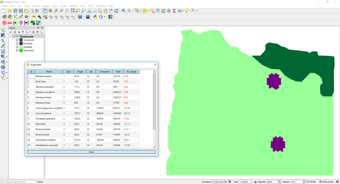
1) Conservation area network gap analysis
CLUZ is designed so users can create a conservation planning system for their planning region, which is based on a planning unit layer and text files that describe the conservation features, list the amount of each conservation feature in each planning unit, and describe how the planning units are spatially connected. CLUZ has functions to import the relevant conservation feature distribution data and specify which planning units are already conserved. Using these data, CLUZ then automatically carries out a gap analysis by reporting the extent to which the existing conservation areas meet the targets for all the conservation features (Fig.
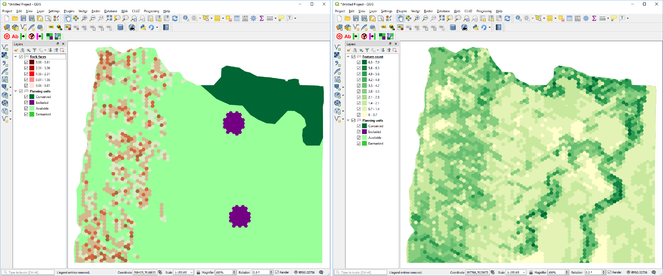
2) On-screen conservation planning
CLUZ has a number of functions to show the distribution of each conservation feature and identify planning units with high biodiversity richness (Fig.
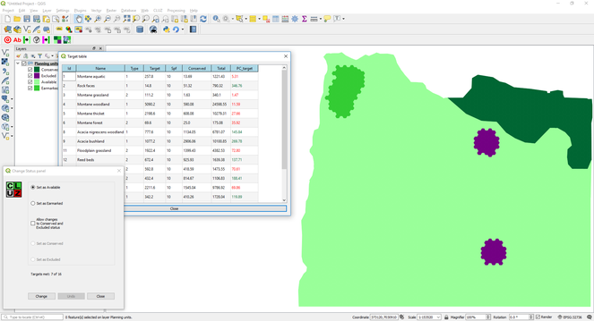
Screenshot of QGIS showing the planning units layer, CLUZ target table and Change Status panel. The Change Status Panel was used to change the status of the patch of planning units in the northwest of the planning region from Conserved to Earmarked. This updated the target table, which shows that adding this new patch to the protected area network would meet the target for rock faces and would contribute towards targets for another five conservation features.
3) Running Marxan
CLUZ is designed to run the Marxan spatial conservation prioritisation software package. It has functions to: export all the CLUZ data into the correct Marxan format; decide on the analysis parameter values by running a set of calibration tools; run Marxan and display the results (Fig.
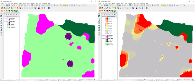
Screenshots from QGIS showing the two Marxan outputs displayed in CLUZ. The map on the left shows the best portfolio of planning units selected by Marxan, while the map on the right shows the selection frequency score of each planning unit based on running Marxan ten times, with planning units in red being selected in every one of the ten Marxan runs.
Project description
this work was funded by the UK Government's Darwin Initiative.
Web location (URIs)
Technical specification
Usage rights
GNU General Public License v2.0
Acknowledgements
Thanks to Neil Burgess, Simon Ferrier, Nigel Leader-Williams, Tom Mullier, Hugh Possingham and Matt Watts for their advice in producing this and previous versions of CLUZ. This version of CLUZ built on a previous version developed for QGIS v2 on a project led by the UN Environment World Conservation Monitoring Programme and with funding from the Global Environment Fund.
References
-
Marxan and relatives: software for spatial conservation prioritization. In: Moilanen A, Wilson K, Possingham H (Eds)Spatial Conservation Prioritization: quantitative methods and computational tools.Oxford University Press,Oxford,185-195pp.
-
Systematic conservation planning.Nature405(6783):243‑253. https://doi.org/10.1038/35012251
-
QGIS Geographic Information System.3.Open Source Geospatial Foundation Project. URL: http://qgis.osgeo.org
-
An approach for ensuring minimum protected area size in systematic conservation planning.Biological Conservation143(11):2525‑2531. https://doi.org/10.1016/j.biocon.2010.06.019
-
Synergies between the key biodiversity area and systematic conservation planning approaches.Conservation Letterse12625. https://doi.org/10.1111/conl.12625