|
Research Ideas and Outcomes :
Workshop Report
|
|
Corresponding author: Tanya M Haupt (thaupt@dffe.gov.za)
Received: 01 Feb 2022 | Published: 08 Mar 2022
© 2022 Tanya Haupt, Jamie Ceasar, Paris Stefanoudis, Charles von der Meden, Robyn Payne, Luther Adams, Darrell Anders, Anthony Bernard, Willem Coetzer, Wayne Florence, Liesl Janson, Ashley Johnson, Roxanne Juby, Alison Kock, Daniel Langenkämper, Ahmed Nadjim, Denham Parker, Toufiek Samaai, Laurenne Snyders, Leshia Upfold, Grant van der Heever, Lauren Williams
This is an open access article distributed under the terms of the Creative Commons Attribution License (CC BY 4.0), which permits unrestricted use, distribution, and reproduction in any medium, provided the original author and source are credited.
Citation:
Haupt TM, Ceasar J, Stefanoudis P, von der Meden C, Payne RP, Adams LA, Anders DR, Bernard AT, Coetzer W, Florence WK, Janson LA, Johnson AS, Juby R, Kock AA, Langenkämper D, Nadjim AM, Parker D, Samaai T, Snyders LB, Upfold L, van der Heever GM, Williams LL (2022) The WIO Regional Benthic Imagery Workshop: Lessons from past IIOE-2 expeditions. Research Ideas and Outcomes 8: e81563. https://doi.org/10.3897/rio.8.e81563
|
|
Abstract
Originating from the Second International Indian Ocean Expedition (IIOE-2), the main goal of the Western Indian Ocean (WIO) Regional Benthic Imagery Workshop, was to provide information and training on the use of various underwater imagery platforms in benthic research. To date, attempts made to explore the bottom of the ocean range from simple diving bells to more advanced camera systems, and the rapidly expanding field of underwater image-based research has supported marine exploration in many forms, from biodiversity surveys, spatial analyses and temporal studies, to monitoring schemes. Alongside the increasing use of underwater camera systems worldwide, there is an evident need to improve training and access to these techniques for students and researchers from institutes within the WIO. The week-long virtual event was conducted between 30 August and 3 September 2021 with 266 participants. Sessions consisted of lessons, practical demonstrations and interactive discussions which covered the steps required to conduct underwater imagery surveys, taking participants through elements of sampling design, data acquisition and processing, considerations for statistical analysis and, effective managment of data. The session recordings from the workshop are available online as a teaching aid which has the potential to reach marine researchers both regionally and globally. It is crucial that we build on this momentum by continuing to develop and strengthen the network established through this initiative for standardised benthic-image-based research within the WIO.
Keywords
Western Indian Ocean, IIOE-2, Regional training workshop, underwater imagery, camera systems, benthic invertebrates, fish communities, habitat types
Introduction
The Second International Indian Ocean Expedition (IIOE-2) is a globally renowned scientific program, running from 2015–2025, aimed at producing new information in almost all disciplines of marine science, while promoting collaboration and capacity development among partners within the Indian Ocean. As part of this effort, in 2017 and 2018, the South African polar and research vessel, the SA Agulhas II, conducted regional training surveys in the waters of Mozambique, Tanzania, and the Comoros. The South African Department of Forestry, Fisheries and the Environment (DFFE) led these expeditions to survey both continental shelf and deep-water environments and train individuals from various organisations within the Western Indian Ocean (WIO) in a number of marine related disciplines (physical oceanography, chemistry, biological oceanography, marine geology, benthic biodiversity, marine top predators and marine plastics). Participants in the benthic biodiversity team were exposed to traditional and innovative research methodologies, with a special emphasis on benthic camera systems.
Since the 1980s, the use of underwater photography in benthic habitats has increased our understanding of their ecology by enabling the collection of descriptive and statistically robust data from shallow and deep (>200 m) habitats (for a review see
Objective
The main goal of the Regional Benthic Imagery Workshop, hosted by the DFFE and sponsored by WIOMSA through its Marine and Coastal Management Programme, was to provide information and training on the use of underwater imagery platforms to better understand and document benthic invertebrate communities and, where applicable, simultaneously sample fish assemblages.
Format and logistics
The Regional Benthic Imagery Workshop was held between August 30 to September 3 2021, led by the DFFE in partnership with Iziko South African Museum, SAIAB (National Research Foundation - South African Institute for Aquatic Biodiversity), SAEON (National Research Foundation - South African Environmental Observation Network), SANParks (South African National Parks), ORI (Oceanographic Research Institute), Nekton Foundation, UKZN (the University Of Kwazulu-Natal), UCT (the University of Cape Town), UWC (the University of the Western Cape), the University of Dar es Salaam Tanzania, the University of Comoros, University of Oxford and Bielefeld University Germany. Scifest Africa (South Africa’s National Science Festival) (https://www.scifest.org.za/) hosted the webinar platform and provided technical support. Lessons, practical demonstrations, and discussion sessions (Table
Lessons listed under various themes for each day of the Regional Benthic Imagery Workshop.
|
Date |
Theme/Session |
Lesson |
|
30 August |
Introduction |
Preliminary findings: IIOE-2 benthic invertebrates (R Payne) |
|
The WIO-Benth project (S Fennessy) |
||
|
Sample design |
Survey and sampling design for visual methods in marine ecology (D Parker) |
|
|
Designing a MPA monitoring plan: key considerations and prioritising objectives and pressures (A Kock) |
||
|
The application of Geographical Information Systems (GIS) to support and standardize methodologies for long-term monitoring (L Williams) |
||
|
Exploring and monitoring benthic biodiversity (T Haupt) |
||
|
31 August |
Data collection using benthic camera systems |
An introduction to camera systems - significance, types, research applications plus advantages and limitations of image-based benthic sampling (C von der Meden) |
|
Operational modes and case studies (searching, exploratory, mapping and monitoring) (G Van der Heever) |
||
|
Marine imagery and video collection using SCUBA, submersibles, and remotely operated vehicles (focus on transect surveys) (P Stefanoudis) |
||
|
Training videos of drop camera and ski-monkey benthic camera systems |
||
|
The value of collecting environmental data in visual surveys (L Adams) |
||
|
1 September |
Data processing (Annotation techniques) and analyses |
An introduction to marine imagery and video annotation software (P Stefanoudis) |
|
Image scaling, general point count methodology (consideration for statistical analyses, selecting number of points for CPCe) (C von der Meden) |
||
|
Image annotation using CPC-e and the CATAMI classification scheme (L Adams) |
||
|
An introduction to BIIGLE - background and functionality (D Langenkämper) |
||
|
Types of analyses for image data (D Parker) |
||
|
Nekton First Descent - Seychelles mission (P Stefanoudis) |
||
|
2 September |
BRUV sampling |
Conducting BRUVs & stereo-BRUVs research (A Bernard) |
|
Monitoring of fish communities at West Coast National Park, South Africa, using BRUVs (S Mayekiso) |
||
|
BRUV video processing, habitat descriptions, QAQC (R Juby) |
||
|
Data management |
Reference collections: The management and conservation of specimen collections (R Payne) |
|
|
Basic data management (A Bosman) |
||
|
Protocols and tools to manage images and data from aquatic biodiversity surveys (W Coetzer) |
||
|
3 September |
Parallel discussion sessions |
Best practices (A Bernard) |
|
Data challenges (L Adams) |
||
|
Infrastructure/collaborations (L Snyders, M Worship, A Nadjim) |
||
|
Let’s chat (T Samaai) |
Participation
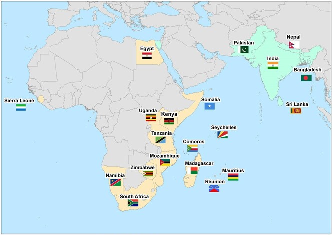
The online workshop drew 266 participants from 21 countries, predominantly from within the WIO region but including a small percentage from neighbouring and affiliated countries (Fig.
Numbers of participants by gender and country within the Western Indian Ocean region and neighbouring/affiliated countries.
|
Country |
Number of Participants |
|||
|
Male |
Female |
Unspecified Gender |
Total |
|
|
WIO |
||||
|
South Africa |
32 |
41 |
- |
73 |
|
Mozambique |
12 |
6 |
- |
18 |
|
Tanzania |
14 |
7 |
1 |
22 |
|
Kenya |
21 |
36 |
- |
57 |
|
Somalia |
5 |
- |
- |
5 |
|
Comoros |
11 |
1 |
1 |
13 |
|
Madagascar |
9 |
6 |
- |
15 |
|
Seychelles |
2 |
10 |
- |
12 |
|
Reunion island |
1 |
1 |
- |
2 |
|
Mauritius |
6 |
8 |
- |
14 |
|
Other |
||||
|
Zimbabwe |
1 |
- |
- |
1 |
|
Egypt |
- |
1 |
- |
1 |
|
Namibia |
2 |
- |
- |
2 |
|
Sierra Leone |
1 |
- |
- |
1 |
|
Uganda |
1 |
- |
- |
1 |
|
India |
2 |
1 |
- |
3 |
|
Sri Lanka |
1 |
- |
- |
1 |
|
Pakistan |
1 |
- |
- |
1 |
|
Bangladesh |
2 |
1 |
- |
3 |
|
Nepal |
1 |
- |
- |
1 |
|
Unspecified Country |
5 |
1 |
14 |
20 |
|
Total |
130 |
120 |
16 |
266 |
Career stages of participants within the Western Indian Ocean and neighbouring/affiliated countries.
|
Number of Participants |
|||||||
|
Researcher |
Lecturer |
Student |
Technician |
Intern |
Unspecified |
Total |
|
|
WIO |
|||||||
|
South Africa |
15 |
2 |
28 |
17 |
5 |
6 |
73 |
|
Mozambique |
8 |
1 |
1 |
2 |
- |
6 |
18 |
|
Tanzania |
9 |
1 |
3 |
7 |
1 |
1 |
22 |
|
Kenya |
30 |
2 |
8 |
5 |
6 |
6 |
57 |
|
Somalia |
- |
- |
3 |
2 |
- |
- |
5 |
|
Comoros |
3 |
1 |
3 |
3 |
- |
3 |
13 |
|
Madagascar |
2 |
- |
9 |
3 |
- |
1 |
15 |
|
Seychelles |
4 |
- |
- |
6 |
- |
2 |
12 |
|
Reunion Island |
1 |
- |
1 |
- |
- |
- |
2 |
|
Mauritius |
- |
2 |
6 |
4 |
1 |
1 |
14 |
|
Other |
|||||||
|
Zimbabwe |
- |
- |
1 |
- |
- |
- |
1 |
|
Egypt |
1 |
- |
- |
- |
- |
- |
1 |
|
Namibia |
2 |
- |
- |
- |
- |
- |
2 |
|
Sierra Leone |
- |
- |
1 |
- |
- |
- |
1 |
|
Uganda |
- |
- |
- |
- |
- |
1 |
1 |
|
India |
2 |
- |
1 |
- |
- |
- |
3 |
|
Sri Lanka |
- |
- |
- |
- |
1 |
- |
1 |
|
Pakistan |
- |
- |
1 |
- |
- |
- |
1 |
|
Bangladesh |
- |
- |
3 |
- |
- |
- |
3 |
|
Nepal |
1 |
- |
- |
- |
- |
- |
1 |
|
Unspecified Country |
- |
1 |
2 |
3 |
- |
14 |
20 |
|
Total |
77 |
10 |
71 |
25 |
14 |
42 |
266 |
Session overview and key highlights
Introduction
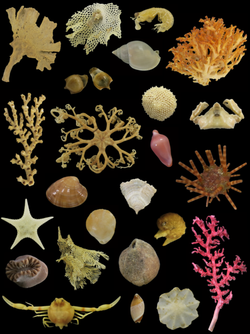
The first session offered an introduction to benthic invertebrates, their importance, and case studies from the WIO. Initial findings of the IIOE-2 expeditions in 2017 and 2018 considered the collection, preservation, cataloguing, and preliminary identification of benthic specimens utilizing a quality-assured workflow (Fig.
Survey design
Session 2 discussed survey/sampling design and statistical considerations for robust use of visual sampling techniques, including key spatial, temporal, and ecological aspects. Lessons covered the design of effective monitoring strategies for Marine Protected Areas (MPAs), which prioritise declared objectives and monitoring of the effects of the main pressures on the MPA. Being an essential component of resource and adaptive management, monitoring was highlighted as means to providing science-based information to guide key management decisions to match park management plans*
Data collection using benthic camera systems
Session 3 explored the suite of options available to collect marine benthic imagery (e.g. Drop-cameras, SCUBA, Baited Remote Underwater Video surveys (BRUVs), Towed Camera, Remotely Operated Vehicles - ROVs, Autonomous Underwater Vehicles (AUVs), and submersibles), which differ in technical complexity, cost, and the expertise required to deploy them (Fig.
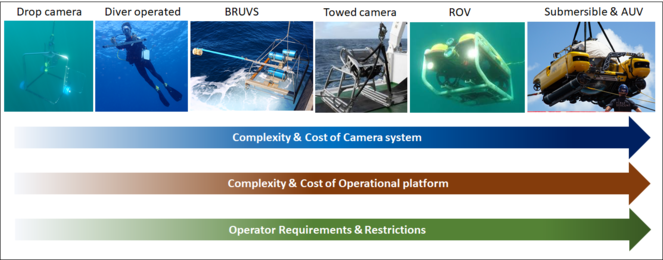
Increasing complexity and cost of visual sampling equipment; the operational requirements for deployment of the equipment, from small craft to large research vessels; and the technical and legal requirements for operators. Photographic credit (Left to Right): Department of Forestry, Fisheries and the Environment (South Africa); Jeanne Mortimer (Island Conservation Society, Seychelles); 3) South African Institute for Aquatic Biodiversity (SAIAB); 4) South African Environmental Observation Network (SAEON); 5) SAIAB; 6) Nekton.
Data processing and analysis
Lessons and practical demonstrations in session 4 addressed the various software packages used to annotate videos and images (on both micro and macro scales) (e.g.
BRUV Sampling
In session 5, lessons and a training video (
Data management
Session 6 focused on data management, from the administration and preservation of reference collections, to the procedures and tools needed to manage images/videos and data from marine biodiversity surveys. Imagery data promotes transparency as it is easily shared among academics and policymakers. As a result, it is possible to create digital archives that can be evaluated and utilized for teaching purposes. At present, large volumes of data are available to the WIO, which may provide excellent possibilities for individuals to become engaged in benthic research and develop new skills. However, most of this data is inadequately inventoried, structured, cleaned, or verified, and access to it is difficult. Data management practises should, as far as possible, conform to international standards to enhance standardisation. Researchers should consider depositing their data into data repositories, which are important tools for safeguarding data, ensuring long-term data preservation and making datasets visible and accessible to other users. Following the correct data management processes will add to the information enabling WIO researchers to better define benthic habitats, to find new species, and to develop other actionable contributions that can be used in spatial conservation planning and management*
Discussion sessions
The last session (7) was devoted to participatory talks in several breakout rooms focused on overcoming obstacles and moving forward with the use of underwater imagery in the WIO. The following topics were covered:
- Best practices, which included regional-scale discussions regarding the best practices for habitat classification via benthic images, open data, common indicators for essential ocean variables and biodiversity reporting at local and regional scales,
- Data challenges, such as the backlog of videos/images that are time consuming to analyse, and overcoming these barriers using automated systems,
- Developing collaborations and infrastructure, where participants were shown how to create an affordable Drop-camera system with discussions on partnership building, and finally
- A general discussion room where attendees could address their subjects of interest*
7 .
Participants’ Feedback
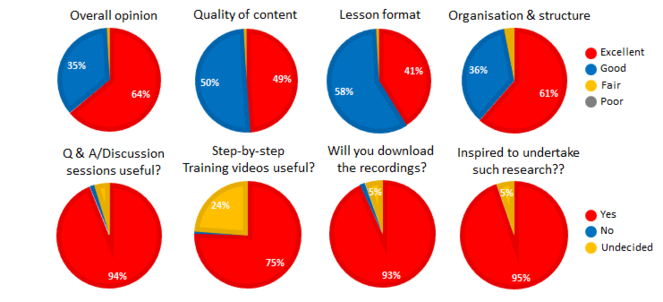
The success of the workshop is evident in the feedback from attendees captured in an online evaluation form (Fig.
Outcomes
The outcomes:
- An internationally attended regional workshop that reached a far wider audience than the original in-person event proposed prior to Covid-19 (i.e. 266 as opposed to only 20 attendees),
- Attendees suitably trained by experts on all the steps required to conduct underwater imagery-based work, and to adopt a multidisciplinary approach to research. In addition to increasing awareness of the value and relevance of this methodology, the training also emphasized how to minimize the technique's shortcomings by employing taxonomy and collections as a verification tool,
- An online training resource - A YouTube channel (https://www.youtube.com/channel/UC3FT8SyYif6X_b1s4zchgog/videos) with all the session recordings is freely available online. This digital legacy has the potential to reach many more marine researchers both regionally and globally,
- The production of step-by-step training videos covering the use of three camera systems - Drop-camera, Towed-camera and BRUVs - available in English and French. These can be used for teaching purposes in addition to being a first step in standardizing techniques among WIO institutes, and
- A gathering of specialists in the subject, and initiation of a network for benthic-image-based research within the WIO and beyond.
Conclusion
Based on questions from attendees, particularly post-graduates and young researchers within the WIO, an evident need exists for the continued development of sampling guidelines and best practice protocols, as well as locally relevant species identification resources and image databases. Attendee’ questions emphasized their eagerness to apply, or enhance existing use of, image-based methodologies in their work. Overall, the wide range of questions raised not just an optimistic perspective for regional marine science, but also demonstrated that many individuals are interested in how to do the finest and most effective research.
An ongoing effort is being made to process and analyze the IIOE-2 images/video and environmental data from 2017 and 2018 with the assistance of specialists identified regionally (South Africa, Mozambique, Tanzania, Comoros) and internationally, with the goal of producing a specimen occurrence and image observation database. All this while continuing to form and strengthen partnerships, as well as build on the momentum established during this workshop. In this way, the lack of resources and infrastructure required to utilise underwater imagery can be seen as an opportunity for promoting collaboration and innovation within the region.
Acknowledgements
We would like to extend our gratitude to WIOMSA and the MASMA programme for granting us the opportunity to host the Regional Benthic Imagery Workshop by supporting and funding the project. Principle Investigators, Dr Christopher Muhando and Dr Twalib Kithakeni from the University of Dar es Salaam Tanzania, as well as Bibiana Nassongole from Universidade Lúrio (Lurio University) Mozambique, are sincerely thanked for their overall involvement in the IIOE2 project: An exploration of the benthos off Mozambique, Tanzania and the Comoros Islands: Diversity, Spatial Variability and Distribution. This Regional workshop was a multi-institutional effort, and we are grateful to our colleagues for their efforts and contributions, from: the DFFE - Dr Gerhard Cilliers, Marco Worship, Brandon Beukes and Steven McCue; Iziko Museums of South Africa - Albe Bosman and Ntombi Fikile; NRF-SAIAB - Willem Coetzer; SANParks - Sisanda Mayekiso, ORI - Dr Sean Fennessy; and the Biodata mining group at Bielefeld University Germany - Prof. Tim Nattkemper and Martin Zurowietz. The team at Sci-Fest Africa were instrumental in the execution of the workshop and we thank Ryan Bruton and the technical support team for their efforts in the months leading up to and including the week-long virtual event. The local film companies OCTOPI-AFRICA (Ltd) and Array Media (Ltd) are thanked for the production of the training videos. We are also thankful to Elsabe Van Rensburg for her administrative support. The workshop would not have been possible without our audience and we extend our gratitude to the particpants for attending and engaging with us throughout the event.
References
- A Standardised Vocabulary for Identifying Benthic Biota and Substrata from Underwater Imagery: The CATAMI Classification Scheme.PLOS ONE10(10). https://doi.org/10.1371/journal.pone.0141039
- Video demonstrating how to set-up, deploy and operate a Baited Remote Underwater Video System, (Training video).Cape Town, South Africa, Octopi Africa (Pty) Ltd and Array Media (Pty) Ltd.OceanBestPractices. https://doi.org/10.25607/OBP-1679
- Potential of video techniques to monitor diversity, abundance and size of fish in studies of marine protected areas.In:Aquatic Protected Areas—What Works Best and How Do We Know? World Congress on Aquatic Protected Areas proceedings.Cairns, Australia,455-464pp.
- Perspectives In Visual Imaging for Marine Biology and Ecology: From Acquisition to Understanding.Oceanography and Marine Biology - An Annual Review54:1‑72. https://doi.org/10.1201/9781315368597
- Video demonstrating how to set-up, deploy and operate a shallow-water drop camera system. (Training video).Cape Town, South Africa, Octopi Africa (Pty) Ltd and Array Media (Pty) Ltd.OceanBestPractices. https://doi.org/10.25607/OBP-1678
- BIIGLE 2.0 - Browsing and Annotating Large Marine Image Collections.Frontiers in Marine Science4https://doi.org/10.3389/fmars.2017.00083
- A field and video annotation guide for baited remote underwater stereo-video surveys of demersal fish assemblages.Methods in Ecology and Evolution11:1401‑1409. https://doi.org/10.1111/2041-210X.13470
- Video demonstrating how to set-up, deploy and operate a Ski-Monkey III towed benthic camera system.Cape Town, South Africa, Octopi Africa (Pty) Ltd and Array Media (Pty) Ltd.OceanBestPractices. https://doi.org/10.25607/OBP-1670
- What is Big BRUVver up to? Methods and uses of baited underwater video.Reviews in Fish Biology and Fisheries27(1):53‑73. https://doi.org/10.1007/s11160-016-9450-1
88% of the participants attended the event to learn more about image-based approaches, while 12% joined to network.
98% of participants agreed that a well-managed MPA would provide significant economic, social, and environmental benefits to their country.
To sample benthic/fish communities, 41% of participants used traditional sampling methods (e.g. trawls, dredge and grab sampling), 28% SCUBA, and only 18% used more complex camera systems (e.g. BRUVs, ROVs, AUVs and submersibles), while 10% of participants used a combination of all three methods. Unsurprisingly, 62% indicated that their institution lacked the capacity and infrastructure to conduct research using more complex camera systems. The most common habitats in which participants worked were sand (21%), coral reefs (20%), and rocky reefs (20%).
73% of participants felt more competent working with image processing and analysis after attending the data processing and analyses session.
Only 45% of participants had experience sampling with BRUVs and stereo-BRUVs with a focus on benthic research to inform management (54%) and to better understand fundamental ecology (46%).
Data storage systems used by participants - portable hard drives (56%), cloud storage systems (18%), network-attached storage systems (14%), and other (12%). Sixty-seven percent used a backup system for data security. To manage data, 71% use spreadsheets, 24% centralized databases, and 4% web-based databases. Only 12% had visited the Global Archive online data repository before attending the workshop, indicating that the majority of participants (78%) were unaware of its – and other web-based databases – existence.
The main factors preventing countries/institutions in the WIO region from using camera systems to conduct marine research are a lack of - funding (29%), infrastructure (23%), and human capacity (14%). Twenty-five percent of the participants are confronted with a combination of all three challenges.