|
Research Ideas and Outcomes :
Grant Proposal
|
|
Corresponding author: Christian Hauschke (christian.hauschke@tib.eu)
Received: 22 Mar 2021 | Published: 14 Apr 2021
© 2021 Christian Hauschke, Daniel Nüst, Anette Cordts, Svantje Lilienthal
This is an open access article distributed under the terms of the Creative Commons Attribution License (CC BY 4.0), which permits unrestricted use, distribution, and reproduction in any medium, provided the original author and source are credited.
Citation:
Hauschke C, Nüst D, Cordts A, Lilienthal S (2021) OPTIMETA – Strengthening the Open Access publishing system through open citations and spatiotemporal metadata. Research Ideas and Outcomes 7: e66264. https://doi.org/10.3897/rio.7.e66264
|
|
Abstract
The BMBF project OPTIMETA aims to strengthen the Open Access publishing system by connecting open citations and spatiotemporal metadata from open access journals with openly accessible data sources. For this purpose, we will extend Open Journal Systems (OJS) to give it functionalities for collecting and distributing open data by developing two OJS plugins for capturing citation networks and articles' spatial and temporal properties as machine-readable and accessible metadata. We will ensure the target group-orientated design of the plugins by performing a comprehensive needs analysis for key stakeholders: the editors or operators of OA journals and the researchers, as authors and readers of articles. The developments will be designed and tested in cooperation with several independent journals and OA publishers. Overall, OPTIMETA supports the attraction of independent OA journals as publication venues by substantially improving the discoverability and visibility of OA publications through enrichment and interlinking of article metadata.
Keywords
open access publishing, open research information, geospatial metadata, open citations
Short description of the project
The OPTIMETA project strengthens the Open Access (OA) ecosystem by capturing articles' citation information and spatiotemporal metadata and transferring these as open data from OA journals to openly accessible data sources. This work contributes to the metadata commons by adding crucial functionalities to Open Journal Systems (OJS), which is the most widely used free and open source software for publishing scientific journals. In this way, the aforementioned metadata can be collected, used by journals and shared with others to enable novel metascience studies and discovery of research artefacts. By combining both open source and open data, journals will be able to offer their respective communities innovative services for linking articles in a semantically meaningful way via geodata and to contribute to open citation graphs, such as COCI (OpenCitations Index of Crossref open DOI-to-DOI,
On the technical side, this project aims to develop two OJS plugins for spatiotemporal and citation metadata, respectively. With these plugins, authors and editors can create or extract the geographic and citation data during an article's publication process, validate it if necessary and transfer it to open, freely licensed data sources, such as Wikidata. Independent OA journals run by the scientific community, professional organisations or universities usually have few human and financial resources (
Idea and research questions
An important part of a future OA ecosystem is a diverse publishing landscape with small and independent journals of high scientific quality. Transformating the landscape towards this vision will not only lead to a change in publishers' business and financing models, but also to stronger commitments by universities and scientists to help establish and operate independent journals and university publishers. Such a commitment is currently fuelled by a growing interest in supporting community-led OA journals (
On the basis of the Open Journal Systems (OJS, https://pkp.sfu.ca/ojs/) publication platform, which is used by more than 10,000 journals, OPTIMETA links OA articles with open data sources through systematic collection of metadata in the areas of spatiotemporal data and citation information. This approach promises to help scholars of all domains to more quickly discover both old and newly-published articles that are relevant for their areas and topics of interest, to work out relationships between research papers in metascience studies and to bring to light otherwise undiscoverable results. The project facilitates the representation of citation networks by including, where applicable, publications from OJS-based journals and research data referenced in the articles. In this way, the increased visibility of the published articles could eventually help bolster the reputations of the OA journals and their scientific authors and may spark new collaborations between otherwise disconnected researchers. OPTIMETA thus gives independent OA journals a technological edge over the commercially operated and mostly closed-off publication platforms.
The software that will be developed for this purpose primarily comprises two OJS plugins. First, the geoplugin records, displays and exposes the spatial extent and temporal scope of the underlying data or topics and issues in the articles. Second, the citation plugin extracts, checks and deposits citation information. Separating these two plugins by theme improves maintainability and reduces the entry hurdle for external developers to contribute to them, as well as for journals or publishers interested only in one of the two areas to install them.
The geoplugin supports authors by offering semi-automatic methods to capture an article's geographical and temporal metadata and to identify these metadata in a semantically unambiguous manner. By analysing and linking geodata, each article is assigned to one or more places or regions and one or more dates or time periods with which it has a direct or indirect relationship. This metadata is published in various machine-readable formats, for example, embedded in the article landing page and integrated into metadata exports. Map representations and visualisations of time intervals (
The citation plugin is dedicated to open citation information and thus specifically addresses the problem described by
In the course of developing and implementing the plugins, the FAIR principles (Findable, Accessible, Interoperable, Reusable;
The OPTIMETA project bundles the considerations described in this work into three groups of research questions. The first group of questions focuses on the researchers, who play an essential role in the perceived quality of a journal with their decision to submit articles to the respective journal, contribute to the journal as reviewers or to cite work published in a journal. The two remaining questions address the journal side and take a look at scientific information systems from a higher-level perspective:
- What criteria do researchers use to make a decision for or against a publication venue? Do "innovative metadata" influence this decision?
- To what extent can the extraction of semantically meaningful metadata, especially citations and spatiotemporal metadata, be automated? Does a high level of automation or usability reduce editors' and publishers' efforts enough to raise their interest in using one or two of the plugins?
- How can fully-fledged citation and geodata be integrated into scientific information systems? What are the limitations to and the potential benefits of better linking and discoverability of articles across individual platforms, for example, for innovative reuse?
Project description
Objective of the project and addressing the purpose of the grant
OPTIMETA extends the well-known publication platform for open access journals, OJS, with citation and spatiotemporal data for each article and thus improves the OA ecosystem on the metadata side. Two OJS plugins enable a large number of OJS-based OA journals to innovatively link publications via a significant improvement in metadata richness, diversity and quality. This strengthens the perceived quality of the publications, significantly increases their discoverability and thereby increases the attraction of small and independent journals. Overall, the project will enable numerous small and independent OA journals to contribute to establishing OA as the standard of scientific publishing, to improve the propagation of OA publications and to lead the way in innovative cooperations, based on free and open source software and open data.
Methodological approach to achieve the objective
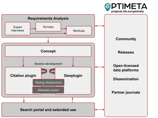
Various methods are combined to achieve the project's objectives. A mixed-methods approach will be used for the needs analysis. Expert interviews with editors and operators of small and independent journals, as well as researchers, will be used to identify key requirements for the design and features of OJS plugins. Later, a quantitative survey of these stakeholders will be conducted to determine their needs and priorities regarding the enrichment of article metadata with citation and geodata. These needs will then be formulated in user stories, on the basis of which the initial conception and the implementation of the two plugins will take place. In an iterative development process, a prototype will be made available to the community for testing and installation at selected cooperating partner journals*
Fig.
State of research, technology and preliminary work
This project can build on various initiatives, developments and preliminary work:
Open research metadata: The Initiative for Open Citations (I4OC) is an important initiative to promote structured and open scientific citation information. Other relevant initiatives include OpenCitations, DataCite Event Data, Crossref Event Data, WikiCite, the Crowdsourced Open Citations Index (CROCI) and OpenAIRE. Citation metadata can be submitted via Cited-by (Crossref, DataCite). A general roadmap for "FAIR Research Information in Open Infrastructures" is currently being developed by the TIB and the State Scientific and Technical Library of Ukraine in the BMBF project FAIRIO.
Persistent identifiers: The PID graph (
Data models for citation information: One of the data models for describing citation information is the Citation Typing Ontology (CiTO,
Geographic metadata for scientific papers: Linking publications, based on spatial and temporal contexts, helps to improve the availability of OA publications (
Impact and scope of the results
The OPTIMETA project's plan to extend the metadata commons will be implemented through the widely used, free software Open Journal Systems (OJS). Since the plugins will be developed bilingually in German and English and published in the OJS Plugin Gallery, all journals that use OJS will be able to benefit from them. In the German-speaking world alone, over 240 journals are based on OJS and, internationally, this number is more than 10,000 (
In principle, all scientific disciplines can benefit from the transmission of citation information and spatiotemporal metadata from OA journals to openly accessible data sources realised by OPTIMETA and, thus, also from the possibility of including citations in open citation graphs. In addition, almost all scientific work has a relation to space and time, whether related to locations of data collection or objects of study, such that the possibility of using geodata to identify articles and research would represent considerable added value for many research disciplines.
Work planning
This section contains a description of the project's work packages and division of labour. The work programme is divided into five work packages and extends over 24 months. In work package 1 (WP 1), we assess the needs of the stakeholder groups to define the framework conditions for conceiving and implementing the planned OJS plugins in the following work packages 2 to 4. In work package 4, the developed OJS plugins are linked to external, open platforms and thus expanded in their application possibilities. Work package 5 focuses on public relations activities, as well as support for the partner journals.
WP 1: Analysis of stakeholder needs
WP 1.1: Conduct a needs analysis via expert interviews and quantitative surveys
Objectives: Survey of the requirements and expectations of the core target groups, namely (a) independent OA journals and university publishers (with a focus on German-speaking countries) and (b) academics from various research fields.
Tasks/approach: We will design, conduct and evaluate five to seven guided expert interviews with editors and operators of selected partner journals, as well as with researchers from different disciplines. This will allow us to collect qualitative information on the editors' requirements and needs regarding the extraction and transmission of citation and geodata. In addition to the already cooperating partner journals, other journals will be contacted and invited to participate. Based on the results of the expert interviews, we will design two quantitative online surveys for both core target groups, test them in a pre-test to be carried out at the TIB and then implement and evaluate them. The target number of participants in each case is 100 to 200 respondents.
WP 1.2: Develop user stories and evaluate prototypes
Objectives: Gather the requirements of the journals and researchers in the form of user stories and evaluate the first prototypical implementations of the plugins in terms of their functionalities and user experience (UX).
Tasks/approach: Based on the results of the expert interviews and the quantitative surveys, we will compile the requirements stated by the journals and researchers into user stories and collect and prioritise them in a public backlog. As soon as the first prototypical implementations of the plugins from WP 3 are available, they will be evaluated in an iterative procedure by conducting further expert interviews and at least one webinar and further requirements for the plugins will be determined. In addition to functionalities, the focus here will also be on UX: which validation steps are necessary before data is transferred to target systems? Which user group (authors, editors etc.) should perform them? Are the range of functions and the associated controls complete and easy to use? For more effective communication with stakeholders, a series of mock-ups are to be created. With the help of the mock-ups, users can better understand the functions and can simulate the work processes, so that any missing steps become visible and new aspects can be found. The mock-ups will be updated at least at the end of the needs analysis and assigned to the appropriate user stories. They will then serve as visual guidelines for the developers. The backlog will also be revised, if necessary, with updated user stories, based on the further interviews and the webinar.
WP 2: Design and prepare for the technical implementation
In work package 2, preparatory measures for the development of the two OJS plugins will be implemented. An overarching goal of the project is that the plugins will be stable and intuitive, as it is likely that users with a wide variety of backgrounds will need to install, administer and use the plugins and any faulty or complex installation processes may limit the distribution of the OJS extensions.
WP 2.1: Design of the OJS plugins
Objectives: Create a concrete conceptual design of the plugins.
Tasks/approach: On the basis of the survey in WP 1 and the project work planning, the technical and content-related foundations for the development of the plugins will be worked out in WP 2 and a technical implementation concept will be drawn up. This includes issues such as determining how exactly to integrate the plugins features into OJS, examining all hooks that are likely to be required and determining which extension options are available or missing in OJS. Furthermore, we will identify which functions require an extension of existing (default) plugins and contact will be made with the respective developers of plugins, for example, metadata export or core functions of OJS, for example, PKP staff.
WP 2.2: Prepare for development
Objectives: Prepare technical measures for plugin development.
Tasks/approach: In preparation for implementation, relevant OJS versions (determined via WP 1) will be installed on an internal test server at TIB. The test server will include the current development version and the latest release of OJS and will be organised in such a way that further versions, identified by the requirements analysis, can be added as needed. The use of containers*
WP 3: Implementation
The implementation of the citation plugin and geoplugin will be done cooperatively by the partners. This large work package will be divided into manageable work stages using an agile, iterative development approach.
WP 3.1: Citation plugin
Objectives: Implement the citation plugin.
Tasks/approach: The OJS plugin for extracting, validating and submitting citation information to open citation indexes will be implemented in several steps. The first step deals with linking two documents with an assigned DOI. For this purpose, the DOI of the source document will be linked to further DOIs located in the document and exported to Open Citations according to the CROCI procedure (
WP 3.2: Geoplugin
Objectives: Implement the geoplugin.
Tasks/approach: First, we will implement the primary needs that can be realised by all supported OJS versions without installing additional software. These include the user-driven metadata collection of simple geometries on the basis of a web map*
WP 3.3: Finalisation, rollout and release of plugins
Objectives: Fixing bugs and releasing versions of single or both plugins as required.
Tasks/approach: Self-discovered or user-identified bugs will be fixed and other user feedback will be incorporated into the plugins as needed. Usability and user experience will be optimised on the basis of ongoing use by the partner magazines. Releases of the plugins will be published as required and, eventually, a final release will be prepared, extensively tested and published in a suitable repository that offers the publication to be citable and available over the long-term, for example, Zenodo. The releases in the OJS Plugin Gallery will be accompanied by in-depth testing by the PKP developers, which will be organised and accompanied in this WP.
WP 4: Export, search portal and extended use
WP 4.1: Metadata export to openly-licensed data platforms
Objectives: Publish the collected metadata in openly-licensed data platforms.
Tasks/approach: In this WP, we will test both of the plugins' connection to different open data platforms with overlapping functionality and implement them in a common code base (M 4.1). For Wikidata, for example, we will need to store geodata as point data (centroid of more complex geometries). Other target systems are Crossref, DataCite, the PID graph and the Open Research Knowledge Graph (ORKG).
WP 4.2: Search portal
Objectives: Design and implement a search portal for OA articles, based on spatiotemporal metadata.
Tasks/approach: In this WP, as a proof of concept, we will conceptualise and implement a prototype of a search portal that aggregates and makes accessible metadata from different OJS-based journals, based on the plugins we created. The search portal provides (a) an intuitive map display of articles from journals across many OJS servers and (b) the possibility for users to subscribe to new publication alerts for specific areas. The portal demonstrates the advantages and opportunities that geospatial data can provide for the discoverability of OA articles. Possible architectures under consideration are a document database that uses a spatial search (e.g. Elasticsearch) and that operates based solely on the open data and its APIs. For the regular collection of data (so-called harvesting) for the document database, both the public target systems (see WP 4.1) and the variants of metadata publication implemented in WP 2 (API, embedded metadata in HTML etc.) will be tested and thus validated. Subscriptions will be implemented in a minimalist way using emails about global time intervals, for example, all articles from the last month at the end of the month, for spatial and temporal sections defined by the user. The user accounts will be managed with passwordless authentication via email. An established standard software for an HTML5-based user interface and a server component will be used (e.g. Leaflet.js, Django), which communicate via an internal RESTful API. The search portal will be installed in the WWU cloud and operated in a publicly accessible manner at least until the end of the project. In addition, we will explore the technical and organisational sustainability of the implementation, for example, by incorporating the functionalities of the search portal into library catalogue or discovery systems.
WP 4.3: Extended use
Objectives: Implement the plugins in other systems.
Tasks/approach: The plugins will be ported and tested in systems that share a code base with OJS: Open Preprint Server (OPS) and Open Manuscript Press (OMP). For this purpose, test datasets with at least 10 articles or manuscripts will be created and entered into local developer installations. Errors or missing functions or workflows that are not covered by the plugins will be corrected within the available time budget or documented in the form of issues with a common tag ("OMP" or "OPS") in the repositories of the plugins if they exceed the time budget. If the plugins are successfully ported, operators of OMP or OPS servers will be contacted and supported in an evaluation of the plugins.
WP 5: Dissemination and support
In WP 5, all work results will be documented for easy reuse and the resulting source code and anonymised raw data of the standardised surveys will be published. In addition, close cooperation will be maintained with a number of partner journals which, at this time, will operate the plugins in full functionality.
WP 5.1: Publications and public relations
Objectives: Engage in target group-orientated public relations, taking into account all stakeholder groups and publish scientific and practice-orientated articles.
Tasks/approach: The project and its current status will be documented on a project website. The developed plugins will be presented at community events (Open-Access-Tage, German-language OJS Developer Workshop, PKP Conference, Bibliothekartag, OASPA Conference) and in practice-orientated online publications. To maintain communication with stakeholders and for further dissemination, webinars will be organised for OJS operators and users, including OJS journals that are not partner journals and especially other journals related to geospatial data, as they are potential users of the geoplugin. The Wikicite and Wikidata communities will be kept informed about the planning and development in order to create awareness around the citation plugin. The results of the project will be documented for future use, which will include presenting the plugins and survey results in typical community communication tools, such as blogs or the PKP forum. In addition, scientific contributions in Open Access publication formats will be prepared and submitted on the basis of the project results. Furthermore, a final workshop with OJS users and operators, as well as members of other stakeholder groups, will be organised at TIB in order to improve the follow-up use of the project results. Finally, a summary report will be prepared.
WP 5.2: Support partner journals and documentation
Objectives: Smoothly install and apply the plugins at the partner journals.
Tasks/approach: The partner journals will be supported by the project staff with installing a pre-release version (at least one partner journal) and the releases of the OJS plugins from the OJS Plugin Gallery (eventually all partner journals). For the first operators, this support will be provided on site and will ideally be combined with a meeting with users, for example, editors and journal managers, to improve the documentation and collect feedback. In addition, manuals on how to handle geodata and citation information will be prepared and given to the journal operators. The user documentation for end users (authors, editors) will also be revised in consultation with selected stakeholders. Furthermore, at the end of the second development phase, all stakeholders of the partner journals, i.e. authors, reviewers, editors and managers, will be invited to participate in an online survey to gather broad feedback on the use of the plugins.
Tabular overview of the scope of work and schedule
Table
|
WP Nr. |
Task sharing |
workload (PM) |
|
1 |
The TIB carries out the requirements analysis using different methods and involving the various external partners and experts. |
TIB: 9 |
|
2 |
The technical conception of the plugins and transfer of the user stories into implementation tasks is carried out jointly by TIB and WWU. The TIB prepares the basic development and test infrastructure and begins as early as possible with the preparatory testing of the basic software as well as related projects and external communication. |
TIB: 3 WWU: 2 |
|
3 |
The WWU is in charge of developing the geoplugin, the TIB the citation plugin. Both institutions are involved in the development of the other plugin to a certain degree in order to ensure a sustainable and effective development and to use synergy effects. The TIB supports the testing of releases by another project staff member and is also responsible for troubleshooting and, if necessary, further development of the plugins during testing after the end of the WWU sub-project, as well as for the releases. |
TIB: 7 WWU: 6 |
|
4 |
The TIB and the WWU jointly realise the shared code base for overlapping export functions of the plugins and the porting of the plugins to other potentially wide-reaching publication platforms. The WWU develops an implementation concept and a prototype for a cross-journal geodata-based search portal with simultaneous testing of harvesting variants. |
TIB: 1 WWU: 3 |
|
5 |
The TIB is responsible for the sustainable dissemination and communication of the project results in various forms of publication, especially in documentation, scientific publications and project reports, as well as in events, especially webinars and the final workshop. The WWU supports the writing of publications and participates in events. WWU and TIB jointly support the partner journals including on-site meetings. |
TIB: 10 WWU: 1 |
|
Total: 42 |
||
Exploitation and reuse of the results
The results of this project open up a variety of possibilities for further use (see also WP 5.1). In addition to the publication of the project results in scientific OA journals, other online publications are planned that should help to make the tools developed in the project known to the professional public. A dedicated website, https://projects.tib.eu/optimeta, will be set up to serve different target groups and will offer examples on how to contribute to the metadata commons and thus to the promotion of OA.
The results will continue to be used by peer-reviewed OA journals or journal platforms as external partners of OPTIMETA*
The citation information and geodata obtained during the project will be collected and published under a free licence with the granting of the broadest possible rights of use, Creative Commons Zero (CC0 1.0). This enables (a) the professional public to use the data developed in this project as a basis for further research and (b) publishers to include it in their own services. Through detailed documentation and software testing, individual journals or publishers can further develop the OJS plugin. In line with practice in the OJS community, the GNU GPL version 3 will be used for software. Texts and graphics will be published under a Creative Commons Attribution 4.0 International (CC BY 4.0) licence and research data will be dedicated to the public domain under CC0 1.0 where possible.
Budget plan
A total of €296k has been requested (TIB: €197k, WWU: €99k). The TIB will provide the project management and the advisory support in the course of the development and implementation of the OJS plugins. Furthermore, the TIB will carry out the installation of the plugins to the journals hosted by the TIB, the hosting of the project website and the provision of facilities for a final workshop.
Acknowledgements
We would like to thank Tom Niers (WWU), Franziska Altemeier, Dulip Withanage and Simone Cartellieri (TIB) for their helpful feedback for this application and Celeste R. Brennecka from the Scientific Editing Service of the University of Münster for her editorial support. This project would not be possible without the support of our partners: Journal of Spatial Information Science; Kommunikations- Informations-, Medienzentrum (KIM), Universität Konstanz; WWU E-Journals, Universitäts- und Landesbibliothek Münster; e-journals Julius Kühn-Institut; Public Knowledge Project; Archäologischer Anzeiger (AA), Deutsches Archäologisches Institut (DAI); heiJOURNALS and Universitätsbibliothek Heidelberg/Universität Heidelberg.
Funding program
OPTIMETA is funded by the German Federal Ministry of Education and Research (BMBF) within the guidelines for funding projects to accelerate the transformation to Open Access (Förderung von Projekten zur Beschleunigung der Transformation zu Open Access,
Conflicts of interest
The authors declare that there are no conflicts of interest.
References
- A longitudinal study of independent scholar-published open access journals.PeerJ4https://doi.org/10.7717/peerj.1990
- Crossref grant IDs: a global, open database of funding information and identifiers.Autumn 2019 euroCRIS Strategic Membership Meeting.Strategic Membership Meeting 2019 – Autumn,Münster,Nov 18-20, 2019.euroCRIS,33pp. URL: http://hdl.handle.net/11366/1249
- Richtlinie zur Förderung von Projektenzur Beschleunigung der Transformation zu Open Access.Bundesanzeiger, Bundesministerium der Justiz und für Verbraucherschutz. URL: https://www.bildung-forschung.digital/files/BAnz%20AT%2017.06.2020%20B3-1.pdf
- VIVO: a system for research discovery.The Journal of Open Source Software4(39). https://doi.org/10.21105/joss.01182
- OCO, the OpenCitations Ontology. https://opencitations.github.io/ontology/current/ontology.html. Accessed on: 2021-2-08.
- Content and context description-How linked spatio-temporal data enables novel information services for libraries.gis.Science4:138‑149. URL: https://www.semanticscholar.org/paper/Content-and-context-description-How-linked-data-for-Degbelo-Kuhn/b31adbb47d54bee3c020c3b374ca14e69d1186aa
- Introducing the PID Graph.(Version 1.0). https://doi.org/10.5438/JWVF-8A66
- Toward the Geoscience Paper of the Future: Best practices for documenting and sharing research from data to software to provenance.Earth and Space Science3(1):388‑415. https://doi.org/10.1002/2015EA000136
- ConfIDent – An Open Platform for FAIR Conference Metadata. In:Open Science Encompasses New Forms of Grey Literature.Twenty-First International Conference on Grey Literature,Hannover,22/23.10.2019.TextRelease,Amsterdam,5pp. https://doi.org/10.15488/9424
- Reference implementation for open scientometric indicators (ROSI).Research Ideas and Outcomes4https://doi.org/10.3897/rio.4.e31656
- Software review: COCI, the OpenCitations Index of Crossref open DOI-to-DOI citations.Scientometrics121(2). https://doi.org/10.1007/s11192-019-03217-6
-
Crowdsourcing open citations with CROCI. An analysis of the current status of open citations, and a proposal.URL: https://arxiv.org/abs/1902.02534
- Mining location information from life- and earth-sciences studies to facilitate knowledge discovery.Journal of Librarianship and Information Science51(4):1007‑1021. https://doi.org/10.1177/0961000618759413
- Discovering Ecologically Relevant Knowledge from Published Studies through Geosemantic Searching.BioScience63(8). https://doi.org/10.1525/bio.2013.63.8.10
- Employing Search Engine Optimization (SEO) Techniques for Improving the Discovery of Geospatial Resources on the Web.ISPRS International Journal of Geo-Information6(9):284. https://doi.org/10.3390/ijgi6090284
- Enhancing Location-Related Hydrogeological Knowledge.ISPRS Int. J. Geo-Inf7(4). https://doi.org/10.3390/ijgi7040132
- In-depth examination of spatiotemporal figures in open reproducible research.Cartography and Geographic Information Science46(9):412‑427. https://doi.org/10.1080/15230406.2018.1512421
- Linked Open Citation Database.Proceedings of the 18th ACM/IEEE on Joint Conference on Digital Librarieshttps://doi.org/10.1145/3197026.3197050
- Ambiguous Geographies: Connecting Case Study Knowledge with Global Change Science.Annals of the American Association of Geographers106(3):572‑596. https://doi.org/10.1080/24694452.2016.1142857
- Small scholar-led scholarly journals: Can they survive and thrive in an open access future?Learned Publishing29(2). https://doi.org/10.1002/leap.1015
- Geospatial Metadata for Discovery in Scholarly Publishing.The 15th Munin Conference on Scholarly Publishing 2020.15th Munin Conference on Scholarly Publishing 2020,November 17–19, 2020.Septentrio Conference Serieshttps://doi.org/10.7557/5.5590
- Visualizing the Availability of Temporally Structured Sensor Data. In:Short Paper Proceedings of the 13th AGILE International Conference on GIScience 2010.13th AGILE International Conference on GIScience 2010,Guimarães, Portugal. https://doi.org/10.31223/osf.io/jq5df
- Über OJS.https://ojs-de.net/ueber-ojs. Accessed on: 2021-2-05.
- Open Citation Identifier: Definition.Figshare. https://doi.org/10.6084/m9.figshare.7127816
- Towards a community-driven, open access university publisher.Research InformationURL: https://www.researchinformation.info/analysis-opinion/towards-community-driven-open-access-university-publisher
- Content and context description How linked spatio-temporal data enables novel information services for libraries.gis.Science4:138‑149.
- Lost locations and the (ir)repeatability of ecological studies.Frontiers in Ecology and the Environment10(5):235‑236. https://doi.org/10.1890/12.WB.015
- CiTO, the Citation Typing Ontology.Journal of Biomedical Semantics1(Suppl 1). https://doi.org/10.1186/2041-1480-1-S1-S6
- In-Text Reference Pointer Identifiers - InTRePIDs.PIDapaloozaURL: https://pidapalooza20.sched.com/event/XlAA
- Large-scale comparison of bibliographic data sources: Scopus, Web of Science, Dimensions, Crossref, and Microsoft Academic. URL: https://arxiv.org/abs/2005.10732
- The FAIR Guiding Principles for scientific data management and stewardship.Scientific Data3https://doi.org/10.1038/sdata.2016.18
- Evaluating Research beyond Scientific Impact. How to Include Criteria for Productive Interactions and Impact on Practice and Society.GAIA - Ecological Perspectives for Science and Society22(2):104‑114. https://doi.org/10.14512/gaia.22.2.9
This takes up the idea of the BMBF-funded project FAIRIO currently running at TIB, which applies the FAIR principles to research information: German National Library of Science and Technology (n.d.): FAIRIO. FAIR Research Information in Open Infrastructures. https://projects.tib.eu/fairio
Even if an API exists and there are cooperations with publishers, the JournalMap is to be seen as a "data sink" and not an open infrastructure (download of data "coming soon", as well as a "non commercial" data licence) and, therefore, not a target system for this application.
Based on the OJS Docker project (beta development status): https://github.com/pkp/docker-ojs/
Points, lines, polygons; acquisition based on Leaflet: https://leafletjs.com/
Proposing (standardised) geometries and names via gazetteers (e.g. GeoNames, https://www.geonames.org/), databases with administrative boundaries (e.g. GADM, https://gadm.org/) and standards data (e.g. Gemeinsame Normdatei - GND, https://www.dnb.de/DE/Professionell/Standardisierung/GND/gnd_node.html).
E.g. via microformats (http://microformats.org/wiki/h-geo) and elements of Dublin Core (Dublin Core 'Coverage' is already rudimentarily implemented as a simple text field in the Dublin Core Meta Plugin, but the use of 'Spatial Coverage' and 'Temporal Coverage', possibly even DCLite4G (https://wiki.osgeo.org/wiki/DCLite4G) should be checked here) and Schema.org (https://schema.org/GeoShape).
Cf. Public Knowledge Project (2020a): REST API Usage Guide. https://docs.pkp.sfu.ca/dev/api/; Encoding e.g. as GeoJSON or Linked Open Data in Turtle (cf. Wikipedia (2020): Turtle (Syntax). In: Wikipedia, The Free Encyclopedia. https://de.wikipedia.org/wiki/Turtle_(Syntax)).
E.g. OAI-PMH (via Dublin Core) and native XML.
The Python library geoextent (https://o2r.info/geoextent/, developed at WWU) can derive geographic and temporal extents from typical geodata formats (e.g, GeoJSON, NetCDF, Shapefile)
Services considered are data repositories, for example, PANGEA (https://www.pangaea.de/) or GFZ Data Services (https://dataservices.gfz-potsdam.de/), catalogues, for example, CKAN (https://ckan.org/portfolio/geospatial/) or OGC CSW (https://de.wikipedia.org/wiki/Web_Catalogue_Service) and spatial data servers, for example, OGC W{C,F}S (https://de.wikipedia.org/wiki/Web_Feature_Service, https://de.wikipedia.org/wiki/Web_Coverage_Service).
PostGIS (https://postgis.net/) for PostgreSQL, spatial data types in MySQL (https://dev.mysql.com/doc/refman/5.7/en/spatial-types.html) and Spatial Search for the OJS Lucene Plugin (https://lucene.apache.org/solr/guide/6_6/spatial-search.html; https://github.com/ojsde/lucene) will be evaluated.
See full list of partner journals and platforms at https://projects.tib.eu/optimeta/en/ .