|
Research Ideas and Outcomes :
Software Description
|
|
Corresponding author: Stefano Della Chiesa (stefano.dellachiesa@geosciconsult.onmicrosoft.com), Aureliano Piva (aureliano.piva@alpconv.org)
Received: 18 Mar 2021 | Accepted: 11 May 2021 | Published: 16 Jun 2021
© 2021 Stefano Della Chiesa, Andrea Vianello, Simone Tritini, Aureliano Piva
This is an open access article distributed under the terms of the Creative Commons Attribution License (CC BY 4.0), which permits unrestricted use, distribution, and reproduction in any medium, provided the original author and source are credited.
Citation:
Della Chiesa S, Vianello A, Tritini S, Piva A (2021) AlpConv Atlas: The Geospatial Content Management System of the Alpine Convention. Research Ideas and Outcomes 7: e66106. https://doi.org/10.3897/rio.7.e66106
|
|
Abstract
Background
The Alpine Convention (AC) promotes research, cooperation and monitoring activities in the Alpine Region. In this framework, the AC Atlas is the official content management system for geographical data published by the Alpine Convention. The AC Atlas' final goal is to promote, collect, organise and disseminate the results of research activities carried out by the Alpine Convention, its Working Groups and by European projects in the Alpine Region.
New information
The system is based on the open-source GeoNode platform supporting standard OGC services. Hence, the AlpConv Atlas allows for browsing, searching, editing documents, layers, maps, and related metadata by an intuitive web-based graphical user interface. The AC Atlas is finally a collaborative platform for managing various geographical data and the related documentation, which can be of great interest to several stakeholders.
Keywords
Geonode; Alpine Convention; Spatial Data Infrastructure; Alps; Atlas; GIS;
Introduction
The Alps are one of the largest continuous natural areas in Europe, with outstandingly unique and diverse landscapes, habitats, culture and history. The Alpine Convention entails the guiding principles towards a sustainable life in the Alps, now and in the future. Article 3 and 4 of the Alpine framework Convention invites the contracting parties to promote research, cooperation, monitoring activities and knowledge dissemination. Within this framework, the Alpine Convention Atlas is the operative tool of the System for the Observation and Information on the Alps (SOIA), providing seamless accessibility and usability of the AC datasets for several stakeholders. The AC Atlas is based on GeoNode
The Alpine Convention spatial data infrastructure
The Alpine Convention spatial data infrastructure (SDI) is based on GeoNode 3.0 installed in a dedicated Virtual Machine (VM) at the front end. It uses GeoServer 2.16.2 as its internal spatial data server. Data are stored in a spatial database, based on PostgreSQL 11. The GeoNode, the Database and the Geosever are installed on a distributed system and run on the private cloud platform of Eurac Research.
Usage
The Alpine Convention Atlas Fig.
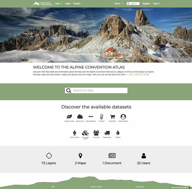
Homepage of the Alpine Convention Atlas.
Project description
Alpine Convention Atlas
The Alpine Convention Atlas stores and disseminates information within the European Alpine Region.
The Alpine Convention Atlas is the operative tool for the Observation and Information on the European Alps (SOIA) of the Alpine Convention.
The development of the Alpine Convention Atlas was possible thanks to the financial support of the Austrian Federal Ministry for Climate Action, Environment, Energy, Mobility, Innovation and Technology.
Web location (URIs)
Technical specification
Usage licence
Additional information
The authors have no conflicts of interest to declare. All co-authors have seen and agree with the contents of the manuscript and there is no financial interest to report.
References
- GeoNode: an open source framework to build spatial data infrastructures.PeerJ7:1‑10. https://doi.org/10.7287/peerj.preprints.27534
- Geospatial Web Services: The Evolution of Geospatial Data Infrastructure. In:The Geospatial Web. Advanced Information and Knowledge Processing.Springer,London. [ISBN978-1-84628-827-2]. https://doi.org/10.1007/978-1-84628-827-2_22
- Developing Spatial Data Infrastructures: The SDI Cookbook. http://gsdiassociation.org/images/publications/cookbooks/SDI_Cookbook_GSDI_2004_ver2.pdf. Accessed on: 2020-12-30.