|
Research Ideas and Outcomes :
Grant Proposal
|
|
Corresponding author: Stelios Katsanevakis (stelios@katsanevakis.com)
Received: 09 Apr 2020 | Published: 13 Apr 2020
© 2020 Stelios Katsanevakis, Konstantinos Tsirintanis, Maria Sini, Vasilis Gerovasileiou, Nikoletta Koukourouvli
This is an open access article distributed under the terms of the Creative Commons Attribution License (CC BY 4.0), which permits unrestricted use, distribution, and reproduction in any medium, provided the original author and source are credited.
Citation: Katsanevakis S, Tsirintanis K, Sini M, Gerovasileiou V, Koukourouvli N (2020) Aliens in the Aegean – a sea under siege (ALAS). Research Ideas and Outcomes 6: e53057. https://doi.org/10.3897/rio.6.e53057
|
|
Abstract
ALAS aims to fill knowledge gaps on the impacts of marine alien species in the Aegean Sea, and support marine managers and policy makers in prioritizing mitigation actions. The project will focus on under-studied alien-native interactions, priority and vulnerable habitats (such as shallow forests of canopy algae and underwater caves), and apply a multitude of approaches. It will apply a standardized, quantitative method for mapping Cumulative IMpacts of invasive Alien species on marine ecosystems (CIMPAL), according to which cumulative impact scores are estimated on the basis of the distributions of invasive species and ecosystems, and both the reported magnitude of ecological impacts and the strength of such evidence. Towards that direction, ALAS will improve our knowledge base and compile the needed information to estimate CIMPAL by (1) conducting a series of field experiments and surveys to investigate the impacts of selected invasive alien species on marine habitats, (2) producing high-resolution habitat maps in the coastal zone, refining the results of previous research efforts through fieldwork, remote sensing and satellite imaging, (3) producing species distribution models for all invasive species, based on extensive underwater surveys for the collection of new data and integrating all existing information. ALAS will incorporate skills and analyses in novel ways and provide high-resolution results at a large scale; couple classic and novel tools and follow a trans-disciplinary approach, combining knowledge from the fields of invasion biology, conservation biology, biogeography, fisheries science, marine ecology, remote sensing, statistical modelling; conduct for the first time in the Aegean Sea a comprehensive, high-resolution analysis of cumulative impacts of invasive alien species; and report results in formats appropriate for decision-makers and society, thus transferring research-based knowledge to inform and influence policy decisions.
Keywords
Biological invasions, Mediterranean, CIMPAL, impact, Aegean Sea, alien species
Excellence
Main Goals, Objectives and Challenges
Alien species are taxa introduced to areas beyond their natural distribution by human activities, overcoming bio-geographical barriers (
Many alien species have become invasive with substantial impacts on biological diversity, human health and ecosystem services. Nevertheless, our knowledge of the effects of alien marine species on biodiversity and ecosystem services is mainly qualitative and largely based on weak evidence (
ALAS aims to contribute towards filling such data gaps and improving our knowledge base on the effects of marine invasive alien species (MIAS) in the Aegean Sea. The project focuses on under-studied alien-native interactions, priority and vulnerable habitats (such as shallow forests of canopy algae and marine caves - habitat types 1170 and 8330 of the Habitats Directive, respectively), and applies a multitude of approaches (such as field experiments, large-scale surveys, satellite imaging and remote sensing, species distribution modelling, and cumulative impacts assessments). It aims to provide answers to important ecological questions on the mechanisms of alien species impacts that will assist marine managers in better decisions of actions for marine conservation and halting biodiversity loss in the region.
ALAS will apply a standardized, quantitative method for mapping Cumulative IMpacts of invasive Alien species on marine ecosystems (CIMPAL), recently developed by
- conducting a series of field experiments and surveys to investigate the impacts of selected invasive species on marine habitats,
- producing high-resolution habitat maps in the Aegean Sea, refining the results of previous research efforts through fieldwork, remote sensing and satellite imaging,
- producing species distribution models for all invasive species, based on extensive underwater surveys for the collection of new data and integrating all existing distributional information of alien species in the Aegean Sea (Fig.
1 ).
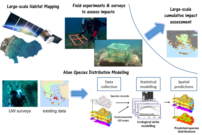
Schematic representation of the ALAS concept. By conducting a number of field experiments and surveys to assess impacts of invasive alien species on marine habitats, large-scale habitat mapping of the entire marine area of the Aegean Sea, and distribution modelling of all invasive alien species, it will be possible to conduct a large-scale cumulative impact assessment of invasive alien species on the marine ecosystems of the Aegean Sea.
State-of-the-Art
The last century, humanity experienced remarkably high rates of development and economic growth. However, this development occurred against the natural capital and without securing the sustainability of natural resources (
Invasive alien species are considered a major driver of global biodiversity loss, due to their severe impacts on ecosystems. Such impacts range from reduction in individual fitness of native species to population declines and local or global extinctions, community-level changes, effects on entire ecosystem processes and ecosystem functioning, health problems in humans or even deaths, and substantial economic losses (
Despite the intensification of research efforts in recent years, there are still substantial gaps in our understanding of the dynamics and implications of biological invasions across regions and taxa. The Convention on Biological Biodiversity (CBD) recognized the need for “further research on the impact of alien invasive species on biological diversity”. Understanding the spread, establishment success, distribution, abundance, spatio-temporal dynamics and invasiveness of alien species is challenging as biological, social, geographic, economic and climatic factors influence the way an invasive species is introduced and interacts with the native biota.
A recent global systematic review (Tsirintanis et al., unp. data) on the experimental methods applied in the terrestrial and aquatic realms for the assessment of impacts of alien species revealed that 20% of the 450 reviewed articles were conducted in the marine environment, among which 13% in the Mediterranean Sea. Most surveys applied manipulative experiments with removals or transplantations, with the chlorophyte Caulerpa cylindracea being the most studied invasive species, followed by the macroalgae Caulerpa taxifollia and Womersleyella setacea (e.g.
To inform management decisions and prioritize the available funds for actions to mitigate the impacts of invasive alien species, many systematic scoring protocols have been developed to integrate and synthesize the empirical evidence of invasive species’ impacts (
Scientific methodology
To apply the CIMPAL approach, the study area (Aegean Sea) will be divided into equal-area cells. For each such cell cumulative impact scores Ic will be estimated as \(I_c=\sum_{i=1}^{n}\sum_{j=1}^{m}A_iH_jw_{i,j}\), where:
Ai is an index of the state of the population of invasive alien species i in the specific cell, transformed and normalized to range between 0 and 1. Abundance or relative abundance data are preferable for this state variable. To estimate Ai, species distribution models will be developed for all invasive alien species. To develop such models, good datasets of alien species records will be needed as well as GIS layers of important environmental variables (bathymetry, temperature, salinity, primary productivity etc.). The former will be created by combining existing datasets, e.g. by retrieving data from the European Alien Species Information Network - EASIN - (
Hj is an index of the extent of habitat j in a specific cell, standardized to range between 0 and 1. Ideally it represents the % coverage of habitat j in the cell. ‘Habitat’ is herein used as a recognizable space, distinguished from neighbouring areas by its physical characteristics and associated biological assemblage. Habitats will be used as the basic unit to identify impacts associated with individual invasive alien species, as they are easily defined spatially. Habitat maps will be created by improving/expanding previous efforts in the framework of the research project MARISCA (
wi,j is the impact weight for species i and habitat j (the higher the impact of species i on habitat j, the higher the value of wi,j). Impact weights will be based on an uncertainty-averse approach as proposed by
Novelty
ALAS will:
- combine skills and analyses in novel ways and provide results at a large scale and high resolution
- combine classic and novel tools (e.g. remote sensing, field experiments and surveys, species distribution modelling, cumulative impact assessments) and follow a trans-disciplinary approach, combining knowledge from invasions biology, conservation biology, biogeography, fisheries science, marine ecology, remote sensing, and statistical modelling
- conduct for the first time in the Aegean Sea a comprehensive, high-resolution analysis of cumulative impacts of MIAS based on detailed habitat mapping, state-of-the-art species distribution modelling, and extensive field experiments and surveys
- conduct large-scale research covering an entire ecoregion (Aegean Sea)
- report results in formats appropriate for decision-makers and society, thus transferring research-based knowledge to inform and influence policy decisions and the general public
- provide cross-cutting deliverables involving theoretical and applied understanding of biological invasions science coupled with the delivery of outputs through information and communication technologies (such as GIS), ultimately rendering efforts for the management of invasive species more effective.
Impact
ALAS will advance marine biological invasions science by applying novel approaches for impact assessments combining many classic and novel tools (remote sensing, field experiments and surveys, interviews, species distribution modelling, cumulative impact assessments). ALAS will fill many knowledge gaps on the impacts of MIAS and the spatial extent and variation of such impacts and will contribute in improving our understanding of the mechanisms of impacts of MIAS on marine ecosystems. It will provide data and results at a large-scale and high resolution, substantially enhancing our perspective of the impacts of alien species in the Aegean Sea.
The cost of marine biological invasions to the economy and human health is huge through a variety of impacts, e.g. causing the decline of commercial fish stocks, the degradation of water quality through harmful algal blooms and the release of toxins, the increase of coastal erosion through the degradation of important habitats for coastal protection, the decline of the recreational value of beaches and coastal areas due to jellyfish blooms, injuries, and degradation of habitats (
ALAS has a strong policy relevance and will support national, European, and international environmental policies and legislation. Specifically, it will support CBD and Aichi Biodiversity Strategic Goal B (https://www.cbd.int/sp/targets/), in particular Target 9, which states that “by 2020, invasive alien species and pathways are identified and prioritized, priority species are controlled or eradicated, and measures are in place to manage pathways to prevent their introduction and establishment”. To achieve Target 9, identification and prioritization of invasive species is a prerequisite. The CIMPAL approach allows for the identification of hotspots of highly impacted areas, and prioritization of sites, pathways and species for management actions, and can thus guide marine managers in their efforts to achieve Target 9 in the region. ALAS will also support the European Biodiversity Strategy, in particular its Target 5. EU Regulation 1143/2014 “on the prevention and management of the introduction and spread of invasive alien species” provisions the creation of a list of invasive species of Union concern, for which management measures will be taken. A requirement for inclusion in the list is a risk assessment and knowledge of the adverse impacts a candidate species has on biodiversity and related ecosystem services. Currently, largely because of limited evidence on the impacts of marine alien species and the difficulties of management measures in the marine environment, the list of invasive species of Union concern includes almost exclusively terrestrial or freshwater species. Hence, by improving our knowledge base on the impacts of marine alien species, ALAS will support the implementation of the Regulation in the marine environment. Finally, ALAS will contribute to the implementation of the Marine Strategy Framework Directive, specifically Descriptor 2 ‘Non-indigenous species introduced by human activities are at levels that do not adversely alter the ecosystems’, in particular Criteria D2C2 and D2C3 of the revised Commission Decision 2017/848.
ALAS will help young researchers (PhDs and PostDocs) to improve their career perspectives and gain international recognition by engaging in novel and high-impact research, which is expected to lead to a number of publications in highly ranked scientific journals. The knowledge, scientific skills, hands-on experience from fieldwork activities, and working on a topic of high policy and socioeconomic relevance will allow young researchers to gain high competence and experience, opening career opportunities.
Implementation
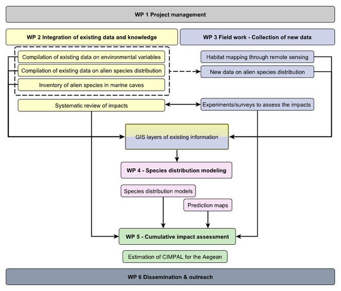
ALAS will be structured in the following 6 Work Packages:
- WP1 Project management: Coordination of the research team. Organization of regular meetings. Internal communication. Administrative management of the project. Communication with the Research Account of the University and the Management Body.
- WP2 Integration of existing data and knowledge: Compilation, harmonization and integration of existing data. Systematic review of reported impacts of MIAS in the Mediterranean. Updating the inventory of alien species reported from Mediterranean marine caves, along with their pathways of introduction and impacts. Creation of GIS layers of existing species distribution data, habitat maps, and environmental data.
- WP3 Field work – collection of new data: Design and implementation of field experiments, surveys, interviews and questionnaires to (1) collect new data on the distribution of alien species, and (2) assess impacts of MIAS on marine habitats, with a special focus on understudied habitats (e.g. marine caves). Remote sensing analysis to produce high resolution maps of shallow habitats.
- WP4 Species distribution modelling: Creation of species distribution models, based on data from WP2 and WP3, applying a Machine Learning Ensemble Modelling approach.
- WP5 Cumulative Impacts Assessment: Conducting a cumulative impacts assessment of MIAS impacts on marine habitats in the entire Aegean Sea, based on the CIMPAL index. Production of maps depicting the spatial variation of CIMPAL. Identification of hotspots of highly impacted areas, and prioritization of sites, pathways and species for management actions.
- WP6 Dissemination and outreach: Dissemination of the project goals and results to the scientific community, marine managers, other stakeholders and the general public. Developing and implementing a communication and dissemination plan, website creation and updating, development and management of social networking platforms, scientific publications, and participation in conferences.
Fig.
WP1: Project management (Months 1-36)
Objectives:
To carry out the management, co-ordination and reporting activities necessary to:
- Ensure effective implementation of the project in collaboration with the funder and the Research Account of the University of the Aegean.
- Achieve smooth and timely flow of information among WPs, good internal communication, efficient completion of all tasks and deliverables.
Description of Work
This work package covers all the management activities of the project. Management activities must be adapted to the needs of the project as it evolves, but will include at least:
- Organize communication between the Research team, the Research Account of the University of the Aegean and the Funder (HFRI) concerning project progress and execution of the Contract.
- Set up and run financial accounting and budget reporting processes – budget monitoring.
- Coordinate progress reporting.
- Monitor the progress of individual work packages, in terms of production of deliverables according to schedule, and other key indicators of progress.
- Continuously monitor significant project risks: identify, assess probability and consequences, and devise mitigation strategies.
- Propose any modifications in the project plan which might be necessary in the light of experience in actually running the project, or due to factors external to the project. Carry out the formal steps needed to obtain approval by HFRI.
- Organize regular meetings among participants
The Principal Investigator (Stelios Katsanevakis) will be leading this WP, and all participants will contribute and share responsibilities for producing the periodic and final reports, as requested by the funder.
Tasks
Τ1.1: Coordination and monitoring activities. All monitoring and coordination activities for the smooth progress of the project towards achieving the stated deliverables. (Months 1–36)
T1.2: Progress Reporting. Organize the drafting of all periodic and final reports. (Months 12, 24, 35-36)
T1.3: Financial accounting and budget reporting. (Months 1–36)
Deliverables
D1.1: First periodic report (Month 12)
D1.2: Second periodic report (Month 24)
D1.3: Final report (Month 36)
Milestones
M1.1: all contracts of the participants are approved and signed (Month 1)
M1.2: kick-off meeting (Month 2)
M1.3: mid-term assessment of the progress (Month 18)
WP2: Integration of existing data and knowledge (Months 1-12)
Objectives
To compile, harmonize and integrate all existing information, relevant for the species distribution modelling and the estimation of CIMPAL. The specific objectives of this WP are:
- To compile and harmonize all existing information on the distribution of habitats and invasive alien species in the Aegean Sea (Task 2.1)
- To update the inventory of alien species reported from Mediterranean marine caves and analyze their pathways of introduction and impacts (Task 2.2)
- To conduct a systematic review of reported impacts of MIAS in the Mediterranean (Task 2.3)
- To create GIS layers of existing species distribution data, habitat maps, and environmental data (Task 2.4)
Description of Work/Tasks
Task 2.1 (Months 1–12)
All the existing information on the distribution of marine habitats and invasive alien species from the scientific and grey literature (journal articles, project reports, dissertations, data bases, monitoring programs etc.) as well as unpublished data (from research institutes, universities, NGOs, citizens) will be compiled. Three types of sources will be utilized: (i) sources of high reliability, i.e. published information that has been peer-reviewed or high-quality databases with an editorial board for validating records, e.g. the European Alien Species Information Network - EASIN - , and the Ellenic Network on Aquatic Invasive Species - ELNAIS; (ii) sources that have not been peer-reviewed and thus further assessment of the reliability of the data will be needed, e.g. project reports; (iii) unpublished data available in the files of persons or organizations. The quality assessment of the type (ii) and (iii) data will be conducted by the participating experts, and if needed further advice of external experts will be sought or validation of the information through targeted surveys will be needed (see Task 3.1). The target habitats will include at least the marine habitats specified in the Habitats Directive (92/43/EEC) but also other habitats of high conservation value. An indicative list includes: Posidonia oceanica beds, reefs, coralligenous formations, marine caves, hydrothermal vents and cold seeps, sandy banks, estuarine systems, and coastal lagoons. For habitat mapping we will build up and improve the habitat maps produced in the framework of the MARISCA project (http://www.marisca.eu/index.php/en/) (
Task 2.2 (Months 1-10)
Marine caves constitute an iconic feature of the Mediterranean Sea with more than 600 caves being distributed along the Aegean rocky coastline and specifically in the island-dominated South Aegean Sea (
Task 2.3 (Months 1-12)
The list of target species will include all alien species that are present in the Mediterranean Sea and are flagged as high-impact species in EASIN or as ‘invasive’ in the Mediterranean in recent published reviews (e.g.
Task 2.4 (Months 3-12)
Distribution maps of all the targeted marine habitats and MIAS in the Aegean Sea will be created in GIS, based on the data compiled through Tasks 2.1 and 2.2.
Deliverables
D2.1: Systematic review paper of reported impacts of MIAS in the Mediterranean (to be submitted for publication in Month 12).
D2.2: GIS layers of the distribution of marine habitats and MIAS in the Aegean Sea based on available data (Month 12)
Milestones
M2.1: The list of targeted habitats and MIAS is compiled (Month 2)
M2.2: Sources of existing information on the distribution of habitats and MIAS are identified (Month 3)
M2.3: The systematic review of the impacts of MIAS is completed (Month 8)
M2.4: Collation of existing information on the distribution of habitats and MIAS is finalized (Month 10)
M2.5: The inventory of alien species reported from Mediterranean marine caves and related information is finalized (Month 10)
WP3: Field work - collection of new data (Months 6-30)
Objectives
To fill existing knowledge gaps regarding the distribution of marine habitats as well as MIAS and their impacts on marine habitats.
The specific objectives of WP3 are:
- To collect new data on the distribution of MIAS (Task 3.1)
- To produce high resolution maps of shallow marine habitats through satellite image analysis (Task 3.2)
- To design and implement field experiments and surveys to assess the impacts of selected MIAS on marine habitats (Task 3.3)
Description of Work/Tasks
Task 3.1 (Months 12-28)
To fill the gaps in our knowledge of the distribution of MIAS in the Aegean Sea and to validate information from sources of low reliability, collected in Task 2.1, surveys to collect new data will be organized. For the needs of this task, a number of missions will be organized utilizing both land means of transfer and vessels. Two types of surveys will be contacted:
- Diving surveys with SCUBA to document the presence and/or estimate the abundance of selected MIAS. A combination of methods will be applied including: strip transects and line transects for the estimation of abundance of alien fish and invertebrate megafauna following the field protocols described in
Thanopoulou et al. (2018) ; repetitive presence/absence surveys to estimate occupancy by jointly estimating detectability based on the methods ofMacKenzie et al. (2006) and following the field protocols developed byIssaris et al. (2012) and applied inKatsanevakis et al. (2017a) ; and photoquadrat sampling to estimate the coverage of alien macroalgae and encrusting fauna utilizing the software photoQuad for the analyses, which has been developed in-house in the Department of Marine Sciences (Trygonis and Sini 2012 ). At least 50 sites with rocky reefs or seagrass meadows and at least 10 marine caves will be surveyed, scattered in the entire case study area. - Interviews: (a) Interviews with fishermen to document the presence of alien fish. Based on a structured questionnaire, inforrmation on the distribution of alien species along with data on estimated catch of native and alien species, changes in the quality and quantity of the catch over the years, and the perception of fishermen on the impacts of MIAS will be retrieved. (b) Interviews with diving clubs / diving associations to document the presence of alien fish, and to assess the perception of divers and tourists on the impacts of MIAS.
Based on the new information the GIS layers of Task 2.4 will be updated.
Task 3.2 (Months 6-18)
High resolution maps of shallow habitats will be produced through satellite image analysis, applying the methodology developed in the MARISCA project (
Task 3.3 (Month 8-30)
After the completion of Task 2.3, a gap analysis will reveal gaps in our knowledge of MIAS impacts. Field experiments or surveys will be designed and implemented to enrich our knowledge base, with special emphasis to habitats of conservation value that are especially vulnerable to biological invasions, such as marine caves (
Deliverables
D3.1: High resolution shallow habitat maps, as GIS layers (Month 18)
D3.2: A paper on distributional patterns of all MIAS in the Aegean Sea by integrating all available distributional data from both Tasks 2.1 and 3.1 (to be submitted for publication in Month 26).
D3.3: A paper on the ecological characterization and diversity of marine caves in the Aegean, with a list of alien species recorded in Mediterranean marine caves and an assessment of their impacts (to be submitted for publication in Month 28).
D3.4: A paper on the results of herbivore exclusion experiments documenting the impact of alien herbivores on macroalgal communities (to be submitted for publication in Month 26).
D3.5: A report on the results of all implemented surveys and experiments (Month 30)
Milestones
M3.1: Plan of diving surveys finalized (dates, sites) (Month 12)
M3.2: The design of all field experiments is completed (Month 12)
M3.3: Start of diving surveys (Month 13)
M3.4: All surveys and experiments completed (Month 23)
WP4: Species distribution modelling (Months 24-34)
Objectives
Το:
- create distribution models for all MIAS in the Aegean Sea, based on data from WP2 and WP3, applying a Machine Learning Ensemble Modelling approach (Task 4.1), and
- produce distribution maps for all these species in the Aegean Sea (Task 4.2).
Description of Work/Tasks
Task 4.1 (Months 24-34)
An Ensemble Modelling approach (
Task 4.2 (Months 31-32)
Based on the species distribution models and the spatial distribution of predictor variables in the study area, prediction maps will be produced for each species. The ArcGIS 10.2.2 software (ESRI) will be used for all GIS operations.
Deliverables
D4.1: GIS maps of the modelled distribution of all MIAS in the Aegean Sea (Month 32)
D4.2: A paper on the modelled distribution of all MIAS in the Aegean Sea – investigating patterns and environmental effects (to be submitted for publication in Month 34).
Milestones
M4.1: All species distribution raw data and environmental datasets compiled and available for modelling (Month 26)
M4.2: Ensemble models completed for all target species (Month 31)
WP5: Cumulative impacts assessment (Months 32-36)
Objectives
To conduct a cumulative impacts assessment of MIAS impacts on marine habitats in the entire Aegean Sea, based on the CIMPAL index. To identify hotspots of highly impacted areas, and prioritize sites, pathways and species for management actions.
Description of Work/Tasks
Task 5.1 (Months 32-36)
The work of this task focuses on the estimation of the CIMPAL index at each cell of the study area (Aegean Sea). The needed data to estimate cumulative impact scores will come from the outputs of WPs 2, 3, and 4. Specifically, the state of the population of the MIAS, Ai, will be estimated by the species distribution models developed in Task 4.1 and their predictions in the study area (Task 4.2), which will be based on the existing (Tasks 2.1, 2.2) and new (Task 3.1) data of the distribution of MIAS in the study area. The index of the extent of habitat j at each cell, Hj, will be estimated through the habitat maps in the study area (Tasks 2.1, 2.4, 3.2). The impact weight, wij, for species i and habitat j will be estimated based on an uncertainty-averse approach as proposed by
Deliverables
D5.1: A paper on the assessment of the cumulative impacts of MIAS on marine habitats in the study area – identification of hotspots, prioritization of species and pathways (to be submitted for publication in Month 36)
Milestones
M5.1: All data needed to estimate CIMPAL is retrieved from the other WPs and formatted accordingly (Month 34)
WP6: Dissemination and outreach (Months 1-36)
Objectives
This work package focuses on the dissemination of ALAS results in order to guarantee a sustainable impact of the project.
The specific objectives of WP6 are:
- To develop the project communication infrastructure (Task 6.1)
- To develop and implement a successful dissemination plan (Task 6.2)
Description of Work/Tasks
Task 6.1 (Months 1-36)
This task will focus on the development and regular update of an external project website hosted at the University of the Aegean as well as a Facebook page and a ResearchGate project. The website and the social network pages will include information on project goals, methodology, research team, and results; detailed descriptions of field protocols; photos and videos from the fieldwork; scientific outputs (articles, posters etc.); and contact information. The website will remain active for at least five years after the completion of the project.
Task 6.2 (Months 1-36)
This task will focus on the dissemination strategy of the project results through a variety of channels. At the beginning of Task 6.2, the ALAS team will specify the project’s dissemination strategy and a time-plan, which will be re-assessed and refined periodically, including dissemination activities organization and implementation, dissemination activities impact and assessment analysis, participation in various events related to the theme of the project. Dissemination methodologies will include conferences, publications, keynote speeches, events, online resources, etc. The efforts will start at project kick-off with a dedicated press release. Outreach to the public through press releases and interviews to the mass media will be organized in collaboration with the Department of Public Relations of the University of the Aegean. During the course of the project, the website and the dedicated social networks will be regularly updated with news on the progress of the project. In addition, the ALAS team will publish peer-reviewed scientific articles, which will be published either as gold or green open-access articles. The task will also implement cross-fertilization activities with running related projects, in particular with EASIN (
Deliverables
D6.1: Dissemination and outreach plan (Month 3)
D6.2: Website and social network pages fully functional (Month 4)
D6.3: Final report on dissemination and outreach, presenting the implementation of the dissemination and outreach plan (Month 36)
D6.4: Policy brief presenting the results of ALAS in an accessible form for managers and policy makers (Month 36)
Milestones
M6.1: mid-term assessment of the progress of the dissemination plan (Month 18)
Funding program
The research work was supported by the Hellenic Foundation for Research and Innovation (H.F.R.I.) under the “First Call for H.F.R.I. Research Projects to support Faculty members and Researchers and the procurement of high-cost research equipment grant” (Project Number: HFRI-FM17-1597).
Hosting institution
Department of Marine Sciences, University of the Aegean, Greece.
References
-
Ensemble forecasting of species distributions.Trends in Ecology & Evolution22(1):42‑47. https://doi.org/10.1016/j.tree.2006.09.010
-
Mediterranean coralligenous assemblages: a synthesis of present knowledge.Oceanography and Marine Biology44:123‑195. https://doi.org/10.1201/9781420006391.ch4
-
Alien species as a driver of recent extinctions.Biology Letters12(2). https://doi.org/10.1098/rsbl.2015.0623
-
A proposed unified framework for biological invasions.Trends in Ecology & Evolution26(7):333‑339. https://doi.org/10.1016/j.tree.2011.03.023
-
A unified classification of alien species based on the magnitude of their environmental impacts.PLOS Biology12(5):e1001850. https://doi.org/10.1371/journal.pbio.1001850
-
Global Biodiversity: Indicators of recent declines.Science328(5982):1164‑1168. https://doi.org/10.1126/science.1187512
-
Exploring the effects of invasive algae on the persistence of gorgonian populations.Biological Invasions14(12):2647‑2656. https://doi.org/10.1007/s10530-012-0261-6
-
ALien Biotic IndEX (ALEX) – A new index for assessing impacts of alien species on benthic communities.Marine Pollution Bulletin87:171‑179. https://doi.org/10.1016/j.marpolbul.2014.07.061
-
Development of a generic decision-support tool for identifying potentially invasive aquatic taxa: AS-ISK.Management of Biological Invasions7(4):343‑350. https://doi.org/10.3391/mbi.2016.7.4.04
-
Spreading dead zones and consequences for marine ecosystems.Science321(5891):926‑929. https://doi.org/10.1126/science.1156401
-
The global distribution and drivers of alien bird species richness.PLOS Biology15(1). https://doi.org/10.1371/journal.pbio.2000942
-
Crossing frontiers in tackling pathways of biological invasions.BioScience65(8):769‑782. https://doi.org/10.1093/biosci/biv082
-
Which taxa are alien? criteria, applications, and uncertainties.BioScience68(7):496‑509. https://doi.org/10.1093/biosci/biy057
-
Marine caves of the Mediterranean Sea: A sponge biodiversity reservoir within a Biodiversity Hotspot.PLOS One7(7):e39873. https://doi.org/10.1371/journal.pone.0039873
-
Alien biodiversity in Mediterranean marine caves.Marine Ecology37(2):239‑256. https://doi.org/10.1111/maec.12268
-
Ecoregion-based conservation planning in the Mediterranean: dealing with large-scale heterogeneity.PLOS One8(10):e76449. https://doi.org/10.1371/journal.pone.0076449
-
Consistency of impact assessment protocols for non-native species.NeoBiota44:1‑25. https://doi.org/10.3897/neobiota.44.31650
-
A Global Map of Human Impact on Marine Ecosystems.Science319(5865):948‑952. https://doi.org/10.1126/science.1149345
-
Occupancy estimation of marine species: dealing with imperfect detectability.Marine Ecology Progress Series453:95‑106. https://doi.org/10.3354/meps09668
-
Historical overfishing and the recent collapse of coastal ecosystems.Science293:629‑638. https://doi.org/10.1126/science.1059199
-
Setting-up a billboard of marine invasive species in the ESENIAS area.Acta Adriatica58(3):429‑457. https://doi.org/10.32582/aa.58.3.4
-
Monitoring marine populations and communities: methods dealing with imperfect detectability.Aquatic Biology16(1):31‑52. https://doi.org/10.3354/ab00426
-
Invading the Mediterranean Sea: biodiversity patterns shaped by human activities.Frontiers in Marine Science1https://doi.org/10.3389/fmars.2014.00032
-
Impacts of invasive alien marine species on ecosystem services and biodiversity: a pan-European review.Aquatic Invasions9(4):391‑423. https://doi.org/10.3391/ai.2014.9.4.01
-
European Alien Species Information Network (EASIN): supporting European policies and scientific research.Management of Biological Invasions6(2):147‑157. https://doi.org/10.3391/mbi.2015.6.2.05
-
Mapping the impact of alien species on marine ecosystems: the Mediterranean Sea case study.Diversity and Distributions22(6):694‑707. https://doi.org/10.1111/ddi.12429
-
Identifying where vulnerable species occur in a data-poor context: combining satellite imaging and underwater occupancy surveys.Marine Ecology Progress Series577:17‑32. https://doi.org/10.3354/meps12232
-
Advancing marine conservation in European and contiguous seas with the MarCons Action.Research Ideas and Outcomes3https://doi.org/10.3897/rio.3.e11884
-
Experimental removal of the invasive Caulerpa racemosa triggers partial assemblage recovery.Journal of the Marine Biological Association of the United Kingdom91(1):117‑125. https://doi.org/10.1017/s0025315410000792
-
Defining the Anthropocene.Nature519(7542):171‑180. https://doi.org/10.1038/nature14258
-
Occupancy estimation and modeling.Academic Press,San Diego.
-
Biological invaders are threats to human health: an overview.Ethology Ecology & Evolution26:112‑129. https://doi.org/10.1080/03949370.2013.863225
-
Prioritizing species, pathways, and sites to achieve conservation targets for biological invasion.Biological Invasions18(2):299‑314. https://doi.org/10.1007/s10530-015-1013-1
-
Cumulative human impacts on Mediterranean and Black Sea marine ecosystems: assessing current pressures and opportunities.PLOS One8(12):e79889. https://doi.org/10.1371/journal.pone.0079889
-
Alien marine fishes deplete algal biomass in the Eastern Mediterranean.PLOS One6(2):e17356. https://doi.org/10.1371/journal.pone.0017356
-
No saturation in the accumulation of alien species worldwide.Nature Communications8:14435. https://doi.org/10.1038/ncomms14435
-
A comparison of absolute performance of different correlative and mechanistic species distribution models in an independent area.Ecology and Evolution6(16):5973‑5986. https://doi.org/10.1002/ece3.2332
-
Assembling ecological pieces to reconstruct the conservation puzzle of the Aegean Sea.Frontiers in Marine Science4https://doi.org/10.3389/fmars.2017.00347
-
How many fish? Comparison of two underwater visual sampling methods for monitoring fish communities.PeerJ6https://doi.org/10.7717/peerj.5066
-
BIOMOD - a platform for ensemble forecasting of species distributions.Ecography32(3):369‑373. https://doi.org/10.1111/j.1600-0587.2008.05742.x
-
biomod2: ensemble platform for species distribution modeling.R package version 2.0.3/r539. URL: http://cran.r-project.org/web/packa ges/biomod2/biomod2.pdf
-
Seagrass mapping in Greek territorial waters using Landsat-8 satellite images.International Journal of Applied Earth Observation and Geoinformation67:98‑113. https://doi.org/10.1016/j.jag.2017.12.013
-
photoQuad: A dedicated seabed image processing software, and a comparative error analysis of four photoquadrat methods.Journal of Experimental Marine Biology and Ecology99‑108. https://doi.org/10.1016/j.jembe.2012.04.018
-
Assessment of grazing effects on phytobenthic community structure at shallow rocky reefs: An experimental field study in the North Aegean Sea.Journal of Experimental Marine Biology and Ecology503:31‑40. https://doi.org/10.1016/j.jembe.2018.01.008
-
Global exchange and accumulation of non-native plants.Nature525(7567):100‑103. https://doi.org/10.1038/nature14910
-
Risk classifications of aquatic non-native species: Application of contemporary European assessment protocols in different biogeographical settings.Aquatic Invasions7(1):49‑58. https://doi.org/10.3391/ai.2012.7.1.006
-
Tropical rabbitfish and the deforestation of a warming temperate sea.Journal of Ecology102(6):1518‑1527. https://doi.org/10.1111/1365-2745.12324
-
How well do we understand the impacts of alien species on ecosystem services? A pan-European, cross-taxa assessment.Frontiers in Ecology and the Environment8(3):135‑144. https://doi.org/10.1890/080083
-
ELNAIS: A collaborative network on Aquatic Alien Species in Hellas (Greece).Management of Biological Invasions6(2):185‑196. https://doi.org/10.3391/mbi.2015.6.2.09
-
Uncertainties and validation of alien species catalogues: The Mediterranean as an example.Estuarine, Coastal and Shelf Science191:171‑187. https://doi.org/10.1016/j.ecss.2017.03.031
-
Deep cleaning of alien and cryptogenic species records in the Greek Seas (2018 update).Management of Biological Invasions9(3):209‑226. https://doi.org/10.3391/mbi.2018.9.3.04
-
Alien species in the Mediterranean Sea by 2012. A contribution to the application of European Union’s Marine Strategy Framework Directive (MSFD). Part 2. Introduction trends and pathways.Mediterranean Marine Science13(2). https://doi.org/10.12681/mms.327
-
Ensemble Methods.CRC Press,London. https://doi.org/10.1201/b12207