|
Research Ideas and Outcomes :
Grant Proposal
|
|
Corresponding author: Carmen Cuenca-Garcia (carmen.cuenca-garcia@ntnu.no@fake_email.com)
Received: 14 Nov 2018 | Published: 15 Nov 2018
© 2018 Carmen Cuenca-Garcia, Kayt Armstrong, Elina Aidona, Philippe De Smedt, Anne Rosveare, Martin Rosveare, Petra Schneidhofer, Clare Wilson, Jörg Faßbinder, Ian Moffat, Apostolos Sarris, Marion Scheiblecker, Abir Jrad, Martijn van Leusen, Kelsey Lowe
This is an open access article distributed under the terms of the Creative Commons Attribution License (CC BY 4.0), which permits unrestricted use, distribution, and reproduction in any medium, provided the original author and source are credited.
Citation:
Cuenca-Garcia C, Armstrong K, Aidona E, De Smedt P, Rosveare A, Rosveare M, Schneidhofer P, Wilson C, Faßbinder J, Moffat I, Sarris A, Scheiblecker M, Jrad A, van Leusen M, Lowe K (2018) THE SOIL SCIENCE & ARCHAEO-GEOPHYSICS ALLIANCE (SAGA): going beyond prospection. Research Ideas and Outcomes 4: e31648. https://doi.org/10.3897/rio.4.e31648
|
|
Abstract
Archaeological sites can be discovered and recorded in a high-resolution and non-invasive manner using geophysical methods. These measure the spatial variation of a range of physical properties of the soil which may be representative proxies of the subsurface archaeology. Less-invasive and cost-effective field procedures have become top-priority to mitigate the destructive effects on our cultural heritage from intensified land use, climate change and the current conflict panorama.
At a time when many organisations are investing in advanced geophysical equipment, a major problem is that our ability to fully interpret the information available from geophysical datasets is still very limited. This deficiency prevents geophysical survey moving beyond basic prospection and becoming a significant tool for answering nuanced questions about archaeology and their host landscapes. This limitation arises from an incomplete understanding of the relationship between soil properties and geophysical measurements. Bridging this gap requires multi-disciplinary teams, testing novel methods, plus scholarly discussion to collate the outcomes of projects on this topic. Overcoming these challenges is a prerequisite for maximising the costeffectiveness of geophysical methods, realising the expected benefits of technological investment and allowing broader utility of geophysical methods in the cultural heritage sector.
SAGA will build an international network of geophysicists, archaeologists, soil scientists and other experts to develop our capability to interpret geophysical data and promote research collaborations. Our vision is that after four years, SAGA will have created an environment within which emerging field procedures, enhanced data interpretation and a broader understanding of integrated geophysical methods can flourish.
Keywords
archaeology, near-surface geophysics, soil science, geoarchaeology, archaeological prospection, soil analysis for archaeological investigations, geoscience
Initial Network of Proposers
See Table
| Proposer | Country | Institution | ORCID | |
| 1 | Dr Philippe De Smedt | Belgium | Faculty of Bioscience Engineering, Ghent University | 0000-0002-7230-4965 |
| 2 | Prof Neli (Daniela) Jordanova | Bulgaria | Bulgarian Academy of Sciences | 0000-0002-9959-4456 |
| 3 | Dr Athos Agapiou | Cyprus | Cyprus University of Technology | 0000-0001-9106-6766 |
| 4 | Dr Roman Krivanek | Czeck Republic | Institute of Archaeology, Czech Academy of Sciences, Prague | |
| 5 | Dr Hana Grison | Czeck Republic | Institute of Geophysics, Academy of Sciences | 0000-0002-0402-2026 |
| 6 | Prof Mika Lavento | Finland | Dept. of Philosophy, History, Culture and Arts, University of Helsinki | |
| 7 | Dr Michel Dabas | France | CNRS | 0000-0001-7405-3453 |
| 8 | Ms Marion Scheiblecker | Germany | Dept. of Earth and Environmental Sciences, LMU München | 0000-0003-2604-1401 |
| 9 | Prof Jörg Fassbinder | Germany | Bayerisches Landesamt für Denkmalpflege | 0000-0003-4271-1153 |
| 10 | Dr Apostolos Sarris | Greece | Foundation for Research and Technology | 0000-0001-6071-4767 |
| 11 | Dr Elina Aidona | Greece | Aristotle University of Thessaloniki | 0000-0002-1974-9105 |
| 12 | Dr Gabor Bacsmegi | Hungary | Munkacsy Mihaly Museum | |
| 13 | Dr Helen Lewis | Ireland | University College Dublin | 0000-0001-5255-074X |
| 14 | Dr Agnese Kukela | Latvia | University of Latvia | |
| 15 | Dr Andra Strimaitien | Lithuania | Lithuanian History Institute | 0000-0002-5559-979X |
| 16 | Dr John Charles Betts | Malta | University of Malta | 0000-0003-3001-3227 |
| 17 | Dr Martijn van Leusen | Netherlands | University of Groningen | 0000-0002-4778-9534 |
| 18 | Dr Carmen Cuenca-Garcia (Main Proposer) | Norway | Dept. of Archaeology and Cultural History, NTNU | 0000-0003-1529-4606 |
| 19 | Prof Jose Mirao | Portugal | University of Evora | 0000-0003-0103-3448 |
| 20 | Dr Andrei Asandulesei | Romania | Alexandru Ioan Cuza, University from Iasi | 0000-0001-8781-0468 |
| 21 | Dr Roman Pasteka | Slovakia | Faculty of Natural Sciences, Comenius University in Bratislava | 0000-0001-6477-8178 |
| 22 | Mr Roger Sala | Spain | SOT Archaeological Prospection (small & medium-sized enterprise-SME) | |
| 23 | Dr Johan Linderholm | Sweden | Dept. of Historical, Philosophical and Religious Studies, Umeå University | 0000-0001-7471-8195 |
| 24 | Dr Abir Jrad | Tunisia | Gabes University | 0000-0002-8718-1216 |
| 25 | Prof Mahmut Göktu Drahor | Turkey | Dokuz Eylül University | 0000-0002-0858-7366 |
| 26 | Dr Kseniia Bondar | Ukraine | ESI "Institute of Geology", Taras Shevchenko National University of Kyiv | 0000-0002-4946-7707 |
| 27 | Dr Kayt Armstrong | United Kingdom | Durham University | 0000-0002-9685-5649 |
| 28 | Ms Anne Rosveare | United Kingdom | TigerGeo (small & medium-sized enterprise-SME) | |
| 29 | Mr Martin Rosveare | United Kingdom | TigerGeo (small & medium-sized enterprise-SME) | |
| 30 | Dr Clare Wilson | United Kingdom | University of Stirling | 0000-0002-0287-8576 |
| COST International Partners | ||||
| 31 | Dr Kelsey Lowe | Australia | University of Southern Queensland | 0000-0002-0857-2877 |
| 32 | Dr Ian Moffat | Australia | Flinders University | 0000-0002-2171-7145 |
SCIENCE AND TECHNOLOGY EXCELLENCE
CHALLENGE
DESCRIPTION OF THE CHALLENGE (MAIN AIM)
Geophysical prospection currently stands as a powerful method in European archaeological research to discover, study and record subsurface archaeological sites. Its importance lies in its capacity to reveal hidden archaeological assets in a non-destructive, rapid and detailed manner in comparison with traditional and more invasive archaeological methods such as excavation or test-trenching. By using geophysical techniques, archaeological remains can be detected remotely, from the ground surface, sea surface or from the air. These techniques measure and map spatial variations of a range of physical properties of the subsoil which may be representative (the proxies) of the subsurface archaeology. In the last decade, a major technological development in geophysical prospection has been the introduction of multi-sensors and motorised instrumentation. This has revolutionised archaeological prospection by allowing extremely fast and high resolution surveys to explore large areas (
Whilst the discipline of archaeological geophysics is going through an exciting phase of technological development, a major problem concerning researchers and practitioners is that our ability to interpret the full suite of information extractable from geophysical datasets has not kept pace with developments in technology and is still very limited. This deficiency prevents geophysical survey moving beyond basic prospection in archaeology and becoming a significant tool for answering nuanced questions about archaeology and the landscapes it is part of. The reason for this limitation is that there is still much to learn about the relationships between soil properties and geophysical measurements. Since the publications of
The main aim of SAGA is to build a multi-disciplinary international network that brings together geophysicists, archaeologists, soil scientists and a wide range of experts in other geoscience sub-disciplines to make a major push forward in our capability to interpret geophysical data for archaeological purposes (not to mention the wider impact of it in shallow depth geophysics in general). SAGA will facilitate cross-disciplinary discussion to establish the state-of-the-art in understanding how soil properties, dynamics and processes affect geophysical data. This will done by synthesising existing knowledge in archaeological geophysics and incorporating the outcomes achieved in other geophysical applications such as geology and civil engineering. The network will establish a research agenda to structure further research and provide a foundation to incorporate the outcomes of existing and future projects. SAGA will set up a network of infrastructure and expertise to facilitate research collaborations and the rapid organisation of survey teams to record and study archaeology at risk. The Action will identify and promote the best integrated strategies for data collection, visualisation and modelling to produce gold-standard procedures and promote them beyond academia. Therefore, a close dialogue with stakeholders (from practitioners to policy makers) will be established to make sure these strategies reach the ‘real word’ in cultural heritage management and that their potential is also known by the general public. A cornerstone of SAGA will be to provide training to students and other interested stakeholders by involving Early Career Investigators (ECIs) and high profile experts employed by the industry and public organisations through training schools and Short-Term Scientific Missions (STSMs) to ensure the longevity of the Action outcomes. Our vision is that after four years of intensive collaborative work, SAGA will have created a framework for emerging field procedures and enhanced data interpretation solutions and facilitated a broader understanding and use of integrated geophysical methods in cultural resource management routines in countries where these methods were not previously common. In countries that already integrate geophysical prospection in cultural heritage management, SAGA will have educated practitioners and curators in the cutting edge of our improved understanding following the integration of and synthesis of concepts, methods and knowledge from adjacent disciplines.
RELEVANCE AND TIMELINESS
This Action is critical right now to help in mitigating the effects of increased intensity of land use practices, climate change and the current conflict panorama that is threatening the preservation of cultural heritage assets. Solutions to develop best practice and less-invasive field procedures to record archaeology at risk, maximise information gathering and train competent geophysicists, have become top-priority in overcoming these contemporary social and environmental challenges for the protection of endangered cultural heritage.
At a time when the European Union and particular nations are making considerable efforts in creating infrastructure for non-destructive geophysical prospection for archaeology, there is an urgent need for justifying these investments. A sustainable long-term plan to maintain and further develop such infrastructures can only be based on demonstrating the full potential of such methods. Efforts in improving field strategies, maximising the information extractable from the different methods and developing solutions to provide more confident interpretations are the best way forward and the reason why this Action is so timely.
Furthermore, the current ‘momentum’ in technological development would greatly benefit from a closer dialogue between manufacturers and research groups to intervene, from the initial stages, in instrumentation and software development and capabilities as well as to coordinate testing and improve field performance.
Another important aspect is that prevailing efforts over recent years to acquire infrastructure, while neglecting to invest in research staff and fund projects, is not sustainable. We are in a crucial moment where it is necessary to balance efforts and stimulate research by investing in human expertise, in making use of and developing the existing infrastructure. By neglecting this, the momentum in the discipline will be lost and the pool of current ECIs redirected to other interests which may lead to an attenuation in research and stagnation in the discipline.
This problem may be exacerbated by the fact that there is a current lack of institutions in Europe providing formal training in the application of geophysics to archaeology, with the consequent threat of a lack of researchers in the future.
Therefore, urgent action is needed to stimulate the status quo of the discipline by promoting collaborations and dissemination activities between researchers and other stakeholders, sharing existing infrastructures and, very importantly, providing training to secure the new generation of geophysicists working in archaeology.
OBJECTIVES
RESEARCH COORDINATION OBJECTIVES
- Creation of a self-sustaining network of researchers involved in archaeological prospection, geoarchaeology, near surface geophysics and other adjacent fields such as high-precision agriculture, engaged in scientific knowledge exchange. This will be achieved by a series of scientific meetings, advanced hands-on Training Schools and specialised workshops over the life of the Action (see section 'DESCRIPTION OF THE WORK PLAN'). This will be measured by the volume and diversity of participation in conferences and workshops over the course of the Action, and in our publications.
- Establish the ‘current state-of-the-art’ in terms of the integration of soil science and geosciences across all forms of near-surface geophysics, and explore how this could be of benefit in specifically archaeological prospection, and vice-versa. This will be achieved by specific invitational workshops involving experts in archaeological prospection and adjacent disciplines presenting their disciplinary ‘state-of-the-art’. Success against this objective will be measured by the production of review publications aimed at archaeological readerships and adjacent disciplines, setting out the current state of play.
- Development of a research agenda exploring where the current challenges lie and what targeted research projects would be of most benefit in tackling them. This will be accomplished in a series of workshops involving experts and stakeholders (see section 'PLAN FOR INVOLVING THE MOST RELEVANT STAKEHOLDERS'). Success of this objective will be measured by the publication of the research agenda and its wider scholarly reception.
- Identify future directions for research and promote new collaborative funding applications from network members. Success against this objective will be measured by the scope and success of such applications.
CAPACITY-BUILDING OBJECTIVES
- Facilitate a series of workshops and training events (in association with its own scientific meetings and existing ones such as those held by Geoarchaeology, International Society for Archaeological Prospection-ISAP, European Association of Geoscientists and Engineers-EAGE and Near Surface Geophysics Group-NSGG) aimed at students and practitioners of archaeological prospection and at varying levels. The network will assess the demand for both specific specialist training in instrumentation or techniques and more general introductions to soil science. It will seek partnerships with organisations with existing capacity in this area, such as the ESDAC, National Soil Resources Institute and the BGS in the UK (and other parallel organisations in partner countries), to develop workshops, laboratory visits and teaching materials in response to demands from the community. The success of this objective will be measured by participant feedback and uptake.
- Creation of a database of experts and equipment to assist in the planning and conduct of primary research in archaeological prospection; archaeology departments and organisations only rarely have the specialist equipment and knowledge to undertake necessary analysis in-house. Currently, access to equipment is achieved through informal professional networks and research collaborations: this will build capacity by opening up those networks to new researchers and in particular for researchers in Inclusiveness Target Countries (ITCs). Success against this objective will be measured by the web publication of the database in a format sustainable beyond the life of the Action.
- Fostering of a diverse network of researchers that achieves a critical mass of competencies to reach the scientific objectives outlined above. This will be achieved through the various workshops and conferences planned for the life of the action, and will be measured by real and tangible progress towards developing joint research initiatives that tackle the research agenda the network will produce.
PROGRESS BEYOND THE STATE-OF-THE-ART AND INNOVATION POTENTIAL
DESCRIPTION OF THE STATE-OF-THE-ART
Geophysical prospection methods have become widely-used tools in archaeological research and heritage management. Academically, the surge of archaeo-geophysics is reflected by the creation of dedicated journals (e.g. Archaeological Prospection) whereas beyond academia this has resulted in national and international guidelines (e.g.
However, the outcome of geophysical prospection does not solely depend on technological advances, but also heavily on environmental setting. Differing soil and geological conditions, alongside environmental factors (e.g. moisture variations), influence the potential of geophysical prospecting strongly as these factors determine contrasts between buried archaeological remains and the surrounding material. Understanding the influence of different environmental settings on various geophysical techniques is essential to fully exploit the potential of these non-invasive approaches. The consideration of environmental settings and in particular of soils and sediments is rarely prioritised during archaeo-geophysical prospection. In addition, careless use of geophysical data often persists in archaeological research. At the heart of this situation lies the complexity of the geophysical method and resultant data, as well as a lack of research effort invested in bridging the gaps between archaeology, geoscience and geophysics.
Recently, however, several research studies have focussed increasingly on such interdisciplinary issues. This includes studies quantifying the contrast and type of geophysical responses such as those looking into geophysical responses on archaeological features (
Beyond archaeological applications, research into very near surface applications of geophysical techniques is equally surging. Here, similar issues are addressed, which relate to interpreting geophysical response to obtain specific information on the natural and/or anthropogenic variations present in the subsurface with applications in agriculture (
A common element of these approaches, however, is their isolated nature. No unified research field covering the influence of environmental settings onto very near surface geophysical prospection exists, and generally accepted regulations or coordinated research approaches are lacking. As a result, the integration of advances in geoscience, geophysics and associated disciplines, is proceeding too slowly, hampering the full integration of these techniques within archaeological research.
PROGRESS BEYOND THE STATE-OF-THE-ART
Advances in the application of geophysical survey methods in archaeology and very near surface studies render a broad base to further the applicability and potential of such methods in archaeological prospection. However, tapping into this often fragmented scientific framework requires bridging interdisciplinary gaps, which remains particularly challenging when interacting between social and natural sciences.
Furthermore, existing methodological advances outside archaeology are not readily transferable to archaeo-geophysics (consider, for instance, the much heavier impact of poor signal to noise ratios in (electro-)magnetic survey equipment in archaeology than in ordnance (metal) detection).
To this end, the creation of a dedicated network is pivotal. The targeted network will, for the first time, combine the existing, albeit fragmented, research frameworks on soil science, geology, geophysics, and archaeology. This can be addressed on three levels.
Firstly, the network will facilitate communicating existing issues and recent advances in archaeo-geophysical prospecting beyond the archaeological community. As such, we strive to integrate the aforementioned existing research frameworks systematically.
Secondly, through interdisciplinary interaction key research issues (both fundamental and applied) will be identified more precisely, resulting in the creation of thematic working groups.
Lastly, the network will translate the cross-disciplinary interaction to educational programmes and commercial applications. This will be effectuated through the integration of study programmes within currentgraduate and continued learning courses, alongside expanding current archaeo-geophysical guidelines. This latter component is equally aimed at increasing the awareness and application of geophysical methods and associated techniques that are rarely implemented, but highly beneficial, for archaeological research.
INNOVATION IN TACKLING THE CHALLENGE
The activities of the network translate into innovations that condense into interconnected technical and socio-economic end-products. On a technical level, the creation of a methodological framework that facilitates bridging the gap between geophysical data and archaeological interpretation is key. At current, geophysical data collection and subsequent archaeological research are rarely conducted in an integrated manner, resulting in sub-optimal exploitation of the archaeological potential of geophysical data and poor archaeological feedback.
A first end-product is therefore the proposal of different methods and instrumentation for calibrating and validating geophysical survey data prior to, or during, follow-up archaeological fieldwork. Such methods should allow straight forward integration into a workflow that takes into account the limitations of non-invasive survey data, while steering the interpretive process towards the archaeological output (e.g. an archaeological site evaluation) more efficiently. Hereby, specific focus should lie on parameterising relevant subsurface properties, which determine the geophysical discrimination potential of the present (geo-)archaeological variation and allow relating archaeological results to geophysical survey data more objectively. Such parameterisation can be achieved through, for instance, developing sampling strategies using geophysical or geotechnical downhole sensors, or by recording relevant (e.g. electrical & magnetic) properties during excavations. Alongside these strategies for ancillary data collection, the network aims to propose software solutions for integrating different data types more efficiently, taking into account the archaeological end-product. Currently, software systems primarily enable visual data combination, without allowing quantitative, and therefore more objective, integration.
A second end-product is therefore the creation of processing protocols or pseudo-code aimed at adaptive data integration. The targeted development and evaluation of integrated survey approaches on a general (i.e. non-site specific) level should lead to more economically viable survey solutions, striving not to implement one set of techniques in favour of alternative survey methods, but towards the most efficient and scientifically robust methodology. The importance of optimising survey procedures increases in challenging environments (e.g. areas of sediment accumulation), alongside areas that are increasingly stressed by project development. Any methodological innovation therefore has direct relevance in archaeological resource management, and the implementation of geophysical methods within developer-led frameworks.
ADDED VALUE OF NETWORKING
IN RELATION TO THE CHALLENGE
Disciplinary groups around topics such as archaeological geophysics, remote sensing and soil science are well established in both academic and non-academic circles, for example, International Society for Archaeological Prospection (ISAP), Aerial Archaeology Research Group (AARG), Remote Sensing and Photogrammetry Society (RSPSoc) and the International Union of Soil Sciences (IUSS) and its special interest divisions and working groups. However, connecting these groups and establishing meaningful dialogue between them has proved difficult. There is a deeply-embedded disciplinary isolation, in terms of journals, conferences, academic structures and policy / commercial frameworks that acts unconsciously to restrict opportunities for lasting cross-over. The result is a wealth of disciplinary knowledge that is fragmented amongst practitioners and academics, and there is an absence of a baseline of common knowledge and language to facilitate communication.
The fundamental nature of this challenge is best addressed by networking and training. Research in and around the topic is, in many instances, at an advanced state, the remaining challenges are best addressed at an interdisciplinary level. SAGA is, by design, deeply interdisciplinary; networks are fundamental to bringing together people with deep specialist expertise and knowledge and to creating the frameworks and spaces necessary to enable the exploration and integrated understandings required to improve interpretation and understanding of geophysical data. Whilst focussed on the interpretation and understanding of archaeological geophysical data, the frameworks for networking and knowledge exchange of SAGA are fundamental to realising the maximum potential of this information to the benefit of all related disciplines.
IN RELATION TO EXISTING EFFORTS AT EUROPEAN AND/OR INTERNATIONAL LEVEL
The problems addressed by SAGA are widely recognised and hence there have been previous attempts to develop interdisciplinary fora and groups. However, these have been more limited in scope and have tended to focus on specific research problems or methods. For example, ArchaeoLandscapes Europe addressed the imbalanced use of the aerial photography and remote sensing in various European countries, whilst DART was focused on the potential of sensors to detect temporal variation in the response of cropmark archaeological sites.
SAGA goes beyond existing efforts, to create a truly crossdisciplinary network of experts, practitioners, trainees and stakeholders. No one current group seeks to link the breadth of expertise within a framework designed to facilitate inter and cross-disciplinary training, communication and research. For example, ISAP is focussed on archaeological geophysics practitioners, but does not offer training or education and does not explicitly facilitate inter-disciplinary discourse, whilst disconnect between commercial and academic annual timetables can limit the opportunities for engagement at conferences for non-academics. There has been recent UN and EU level focus on soils that has brought increasing recognition of the existence and importance of cultural soils and the cultural heritage ecosystem service / function of soils. However, these actions have tended to lack visibility outside of soil science and additionally struggle with classification of cultural / anthropogenic soils. However, the experience and existing communication frameworks of more discipline / question focussed fora will provide useful hubs to facilitate communication and engagement.
SAGA will interface with existing active groups, wherever possible, for example co-locating meetings and workshops, making use of established contacts and infrastructures. Such an approach will maximise SAGA’s reach and impact and help to create a self-sustaining long-lived structure that will also help reinvigorate the wider community.
IMPACT
EXPECTED IMPACT
SHORT-TERM AND LONG-TERM SCIENTIFIC, TECHNOLOGICAL, AND/OR SOCIOECONOMIC IMPACTS
Due to the nature of the proposal, several distinct short-term impacts are expected, some also with longer lasting effects. Other impacts are expected primarily in the long-term, many of which build on outcomes from activities. The impacts below flow loosely in order of earliest anticipated timescale. There will be a fresh focus of attention on this subject area, starting with the disciplines of archaeology, soil science and shallow geophysics. The importance of cross-discipline and cross-sector communication and work will also be brought to the attention of colleagues in related subject areas. This wider group of stakeholders will become aware of the existence and relevance to them of this subject area, a precursor to other impacts in multiple ways.
The proposal will provide an impetus to encourage collaborations and expand the number of active international connections. It will be substantially easier to organise new interdisciplinary collaborative research. As well as a short-term impact, following the initial impetus, the links formed between sectors and disciplines will permit more cross-fertilisation of ideas and bring together parties who were otherwise less likely to have found common research interests.
The improvement of training, including post-qualification training, across the sectors will increase the confidence of those working in the subject to use results from these other sectors. One specific impact in this area is for those currently studying and qualifying, to receive increased and improved content in the subject area that ties in with their field of study; another is for end users such as heritage and environment professionals, project and land managers to obtain an increased awareness of the uses and benefits of integrating this subject into their programmes. Practitioners with little or no access to training in the subject will have opportunities to engage with programmes designed to provide them with applicable knowledge and skills. A further relevant impact is for those responsible for education and training across the sectors to update their own understanding, recognising that developments in technology, methods, applications and outcomes have occurred since they qualified or trained. Together, these impacts will ensure that the foundation is laid for better understanding and practice amongst the current and future generations of practitioners.
The proposal will lead to a substantial improvement in access to expertise and equipment in areas with low current accessibility. This has multiple facets: in some cases, it will facilitate experience, combined with an element of expertise transfer and training, of particular equipment and methods where there has not been local availability to even demonstrate those. The application of methods in specific environments or locations in conjunction with local collaborators is often a key stage in enabling wider geographical use of established techniques. Specific improvements to the processing and interpretation of prospection data, along with a growth in broader understanding of principles and application of the techniques used, will increase the profitable re-use of data already collected, including locally and regionally held archives spanning decades, in addition to boosting the outcomes from current and future prospection work. Sharing and evaluating these improvements through networks will make possible the crucial step from local incremental improvements to large, network-wide impacts.
One of the key areas addressed is the improvement of overall outcomes for heritage assessment, whether in a development, management or research context. In particular, we expect a positive impact from the increase in openness and transparency to end users, resulting in more realistic expectations of what geophysics and soil science can do for them and of how they can best work with specialists to optimise outcome from resources available to their projects. Responsible, time efficient, value for money development for construction, agriculture, mining, etc. will be facilitated. Improvements in public perception and visibility of the discipline will increase investment, commercial demand and employment outcomes. As this subject area continues to develop, the network will be able to provide much-needed support, influence and technical material, including, where appropriate, reference material, case studies and material for best practice guides. A more solid multifaceted basis for the study of archaeolandscapes, historic buildings etc. will be formed and emerging technologies will be able to contribute more directly and fully to cultural heritage, whether through knowledge, management or protection.
Long term cooperation and engagement beyond the included disciplines will be encouraged by the increased visibility of a more coherent and active network, particularly those working with soil properties (e.g. geotechnical and other shallow geophysical applications) and the wider environment (e.g. ecologists, agronomists and hydrologists). This builds towards an overall cooperation as "curators of the soil", now more necessary than ever given the pressures on this precious resource. Foundations will be formed for future research networks and collaborations. Through establishing coherent research and investigation areas and bringing together groups of interested parties, it will be possible to manage the development of new methods and contribute to sensor and system development with manufacturers. Technology development cycles for geophysical sensors generally take much longer than changes in data acquisition and handling. New applications and methods will be more quickly and reliably developed with a coordinated effort.
MEASURES TO MAXIMISE IMPACT
PLAN FOR INVOLVING THE MOST RELEVANT STAKEHOLDERS
The need to find and involve stakeholders is essential to ensure both skills transfer between academia and other professional sectors and also to ensure that training and research agendas meet the needs of the practitioners. By involving interested parties as stakeholders it is hoped that the concept of a two-way flow of information and resources will be promoted. Stakeholders need to be drawn from across geophysics, geoarchaeology, academic research and curatorial bodies. To ensure credibility and accountability within the archaeological profession, certain archaeological organisations will also need to be involved. This last point is especially relevant for the promotion of and uptake into training activities, for which integration with existing events and training frameworks will be essential. However, archaeological events and frameworks with particular relevance to soil science are currently lacking and SAGA will need to provide new opportunities.
One group of stakeholders, selected on the basis of their support for training and their existing membership, include the: International Society of Archaeological Prospection (ISAP), International Union of Soil Sciences (IUSS), European Association of Geoscientists and Engineers (EAGE), European GPR Association (EuroGPR). The Action will work with each of them to develop training initiatives and materials, utilising existing frameworks and facilities where possible. Specialist sessions and workshops could be created and integrated within existing conferences (e.g. EAGE's annual Near Surface, ISAP's bi-annual Archaeological Prospection, the annual International Workshop on Advanced Ground Penetrating Radar). Similar opportunities should be sought at other conferences.
A second group of stakeholders includes research institutes and commercial geophysical and geoarchaeological companies, partly to guide and implement research and partly to provide opportunities for researchers and others to train. Without integration with these bodies the legacy of SAGA is potentially not assured.
Technical partners, likely in the provision of data, represent a third set of stakeholders and these potentially include: European Geological Survey units, European Soil Data Centre (ESDAC), National Soil Resources databases.
A fourth set of stakeholders would include state level heritage curators, trade bodies, labour organisations and archaeological societies, most likely as recipients of specialist and targeted training and for their advice on perceived training needs and curatorial decision making. This group would likely also include larger archaeological and construction companies with oversight of the technical challenges of landscape-scale projects.
Looking to the future, training has to become integral to the practice of soil science and geophysics, which needs to attract and retain skilled geoscientists. Some effort needs to be made, to enthuse those yet to enter it and especially those embarking upon university studies and considering career paths. Events to publicise the discipline amongst younger people (e.g. by supporting extra-curricular school and university activities) should be considered.
DISSEMINATION AND/OR EXPLOITATION PLAN
Given the wide range of sizes, types and primary interests of the stakeholders, publicity and dissemination has to be both comprehensive and accessible. The Action activities need to be promoted across a wide range of social and other media. Use of such media should also include promotion of other events and publications relevant to SAGA, as part of the community building objective. Alongside this, the activities of the Action should result in formal and informal publication (e.g. through academic channels, especially those that are open-access) and through recordings of events made available on media (e.g. YouTube).
The use of social media is especially important to support the continued interest of commercial practice which frequently lacks access to academic publications, plus it is essential for keeping the activities of SAGA current and maintaining presence.
Within the commercial sector, recent research suggests uptake of traditionally published materials is low, apparently for reasons of cost and time: information therefore needs pushing into the sector as a specific objective. News and advice from the Action must be commercially relevant, so targeted at real-world problems and should encourage feedback and dialogue.
The multinational aspect of the SAGA means that while it is probably reasonable to expect most interested parties to have a working proficiency of English, physical attendance at events is going to difficult for many. Taking micro-events, e.g. conference sessions, to existing larger events is more likely to succeed in terms of footfall than the Action hosting stand-alone events.
Dissemination of teaching and other materials online will help reduce geographic constraints upon opportunity and give a life beyond the Action to the training materials developed. The presentation of published material must be gender, geography and language-neutral to assist with encouraging new entrants to the discipline and to overcome perceived barriers to career progression. The dissemination of training materials will require negotiation of access and rights on a per stakeholder basis to ensure their Intellectual Property Rights (IPR) are adequately protected. It is hoped that stakeholders who are committed to training and career development will reduce or waive financial reward for online materials in return for the additional publicity they receive, but the Action understands this might not be possible in every case.
An objective is the development of mutually beneficial networks of professionals across commercial operators, researchers, educators and equipment manufacturers, through face-to-face and online contact. Within the academic arena this can be achieved through guest lectures and seminars and student and researcher exchange visits, but for research to reach the commercial sector it will need to be taken to it (e.g. through the provision of workshops). In return commercial internships for students and researchers should be encouraged.
Another objective is to ensure that the experiences of the commercial community and academia reaches the manufacturers of equipment and software, to encourage refinement of systems and to provide input into future developments.
Less specific proposals for dissemination include traditional means like contributions to journal papers, edited books and professional guidelines and protocols.
There will be a website through which SAGA activities can be publicised and links to recordings and other summaries of conferences, workshops, field demonstrations and other activities made available, alongside abstracts and publications from these. Interest has been expressed in the creation of a technical discussion forum to assist with real world problem solving, sourcing reference materials and case studies and similar queries. Non-traditional media uses include the use of social media to publicise SAGA events and to provide links to training and other materials hosted by the Action's website.
Social media would also be used to help promote relevant stakeholder activities as part of community building. Twitter is ideal for providing links to materials and events while Facebook is better for short summaries of events and photographic galleries. LinkedIn can likewise host summaries and short non-peer-reviewed material. Peer-reviewed materials can be disseminated via ResearchGate or Academia.edu.
POTENTIAL FOR INNOVATION VERSUS RISK LEVEL
POTENTIAL FOR SCIENTIFIC, TECHNOLOGICAL AND/OR SOCIOECONOMIC INNOVATION BREAKTHROUGHS
Given what is explored above in terms of the current state of the art, SAGA’s efforts to consolidate knowledge and practice across disciplinary boundaries will generate scientific breakthroughs for the core discipline of archaeology. In particular, the efforts towards parameterisation might lead to new methods and instrumentation, in collaboration with industry partners, or the adoption and adaptation of established methods from adjacent disciplines. These breakthroughs will in turn generate socioeconomic outcomes in terms of the role of non-invasive archaeological prospection in the development & planning process, for heritage management (site detection and monitoring) and for wider social interest in understanding the past.
The risks are more around reaching the right people and ensuring the dissemination is effective, and that the working groups stay in close contact and work well together. These risks have been mitigated by the design of the network structure, in particular by having a Working Group focused on dissemination activities and by having SME’s embedded in the original design of the proposal. SAGA will seek mentorship from previous COST Action chairs and Working Group leaders to ensure we make the most of the opportunities afforded by the Action.
SAGA will remain open to new members during its life cycle, so that new partners can be added if we discover key areas of the field not included in the original proposal via outreach and dissemination efforts. Furthermore, we will ensure the major stakeholders in this field are involved from the outset (see section 'PLAN FOR INVOLVING THE MOST RELEVANT STAKEHOLDERS').
IMPLEMENTATION
DESCRIPTION OF THE WORK PLAN
DESCRIPTION OF WORKING GROUPS
SAGA consists of the following four Working Groups (WGs) that emerged from the identified challenges for this Action:
WG1: KNOWLEDGE CREATION, EXCHANGE & DEVELOPMENT
Objective: Structure the knowledge of fundamental soil parameters involved in the detection of archaeological features using geophysical techniques with the goal of maximising data interpretation. This WG will also create an online resource sharing relevant publications and promote the development of collaborative research proposals.
Tasks: Discuss and synthesise the findings of past studies exploring how land use practices, high variability in soil properties, soil post-depositional and other taphonomic processes within archaeological features may have an effect on geophysical prospection; Synthesise the outcomes of the various monitoring programmes (for example, of short term climate fluctuations) on archaeo-geophysics that have been completed; Review the results of the application of combined soil science and geophysical methods in exploring a range of sites (e.g. prehistoric tell-sites, caves & rockshelters, metallurgical sites, grave/burials, post-industrial landscapes) as well as mapping areas of risk of loss of cultural sediments and archaeological assets (e.g. wetlands, littoral zone); Based on these discussions, the WG will produce recommendations for further research and create opportunities to develop collaborative research proposals; The outcomes of the discussions will be reported and showcased in SAGA website as well as an online database of relevant literature; Review the accessibility to researchers of commercially-held archives and to document their existence and utility.
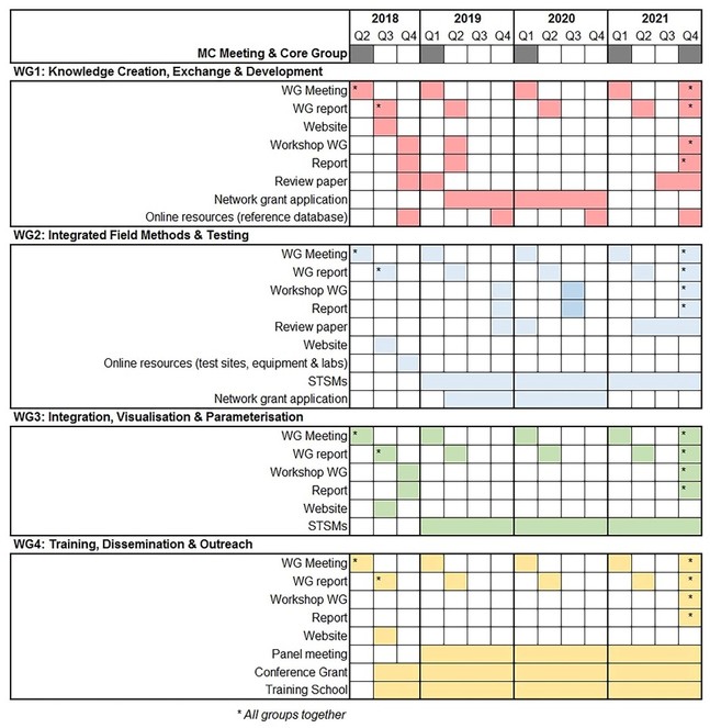
Milestones & Deliverables: Year 1 (WG meeting to organise and report on membership and plan activities (M1.1), WG meeting report (D1.1), set-up SAGA website (D1.2), workshop to review the outcomes of past projects and applications (D1.3), workshop report (D1.4), develop an online list of the relevant publications, projects and applications (D1.5)); Year 2 (Annual WG meeting to organise and report on membership and activities (M1.2), WG meeting report (D1.6), workshop to develop research proposal (in collaboration with WG2 and/or WG3) (D.1.7), at least one network grant application submitted (in collaboration with WG2 and/or WG3) (D1.8)); Year 3 (Annual WG meeting to organise and report on WG membership and activities (M1.3), WG meeting report (D1.9), review existing and to develop new research proposals (in collaboration with WG2 and/or WG3) (D1.10), at least one network grant application submitted (in collaboration with WG2 and/or WG3) (D1.11)); Year 4 (Annual WG meetings to organise and report on membership and activities (M1.4), WG meeting report (D1.12), final workshop to integrate new findings and plan legacy (D1.13) (all WGs), workshop report (D1.14), review paper (D1.15), final report (D1.16)).
WG2: INTEGRATED FIELD METHODS & TESTING
Objective: Explore, discuss and evaluate integrated approaches using geophysical, archaeological and soil sampling methods with the goal of identifying gold-standard field solutions for data collection. The WG will also assemble a network of test-sites, instrumentation and labs to facilitate field experimentation and provide a pool of equipment to share between the members.
Tasks: Assess soil-sampling strategies used to support the information provided by geophysical prospection of archaeological sites as well as for data validation. The WG will explore soil sampling, processing and analytical solutions to incorporate in intra-site or large-scale prospection in a cost-efficient manner. The results of these experiments will lead to a library of soil / sensor signatures that can be available online for the various practitioners; Development of a framework for more efficient archaeological sampling strategies (e.g. trial trenching) in combination with geophysical surveys will be another main task for the group. A main goal will be to create efficiency workflows to be used in developer-led archaeology (in coordination with WB 4); Assess the potential of innovative field methods such as: downhole geophysics, geotechnical methods and coring for palaeolandscape investigation; linking ground-based geophysical techniques with airborne and satellite remote sensing to characterise archaeological landscapes; integrating geophysical and inorganic and organic geochemistry in archaeological investigations; Produce a series of best practices publications and deliver reports on SAGA’s website; Identified best-practices will be promoted for their use in routine applications between curators, practitioners and students, in coordination with WB 4; Ad hoc meetings, video-conferences or STSMs will be allocated to seek for advice on, for example, the potential of specific field methods before undertaking fieldwork or how to run monitoring equipment; Develop an online resource of test-sites, equipment and laboratories to support experimentation, monitoring projects and facilitate access to appropriate equipment for ‘heritage at risk’ projects or collaborative research (in coordination with WG1 and 4).
Milestones & Deliverables: Year 1 (WG meeting to organise and report on membership and plan activities (M2.1), WG meeting report (D2.1), set-up network of test-sites, equipment and laboratories on SAGA’s website (D2.2)); Year 2 (Annual WG meeting to organise and report on membership and activities (M2.2), WG meeting report (D2.3), at least one workshop on integrated methods / sampling strategies (D2.4), at least two STSMs on field methods (D2.5)); Year 3 (Annual WG meeting to organise and report on WG membership and activities (M2.3), WG meeting report (D2.6), at least one workshop on integrated methods / sampling strategies (D2.7), at least two STSMs on field methods (D2.8)); Year 4 (Annual WG meetings to organise and report on membership and activities (M2.4), WG meeting report (D2.11), at least two STSMs on field methods (D2.12), final workshop to integrate new findings and plan legacy (all WGs) (D2.13)).
WG3: DATA INTEGRATION, VISUALISATION & PARAMETERISATION
Objective: Identify and evaluate innovative solutions for multivariate proxy data analysis. SAGA will seek and propose ways of data integration resulting from soil analytical techniques, environmental parameterisation and sensor signals registered by various instrumentation. Prior to the investigations, forward modelling based on soil properties is crucial to provide a proxy on the successful application of specific techniques. After the survey, the integration of data from various instrumentation, combined with the results from soil analysis can considerably enhance the interpretation of the data.
Tasks: Beyond co-display, the WG will work to find solutions for ‘real’ data integration for spatial analysis and 3D display; consider the potential of forward modelling parameterisation in archaeo-geophysics for survey planning and data interpretation.
Milestones & Deliverables: Year 1 (WG meeting to organise and report on membership and plan activities (M3.1), WG meeting report (D3.1), workshop to assess needs and best solutions for data integration and forward modelling (D3.2)); Year 2 (Annual WG meeting to organise and report on WG membership and activities (M3.2), WG meeting report (D3.3), at least one STSM (D.3.4)); Year 3 (Annual WG meeting to organise and report on WG membership and activities (M3.3), WG meeting report (D3.5), at least one STSM (D3.6)); Year 4 (Annual WG meetings to organise and report on membership and activities (M3.4), WG meeting report (D3.7), at least one STSM (D3.8), final workshop to integrate new findings and plan legacy (D3.9) (all WGs)).
WG4: TRAINING, DISSEMINATION & OUTREACH
Objective: Demonstrate the benefits of incorporating soil science and geophysics during excavation planning phase to curators, field archaeologists and students. Promote the benefits of soil analytical techniques for generating auxiliary data. Develop specialist skills and cross-disciplinary capacity (common language, common problems). A crucial module of SAGA will be the hands-on practical training of young researchers and professionals.
Tasks: Organise Training Schools with practical demonstrations on in key technical areas (including soil science, geophysics and geochemistry) (in collaboration with WG2); Develop and distribute training materials though SAGA’s website; Organise panel meetings that are ‘problem’ focussed (in collaboration with WG 1, 2 & 3); Administrate STSMs & ‘Access to Experts and Equipment’; Provide online mentoring/forum for the use of equipment, specific techniques, analytical techniques (in collaboration with WG1); Coordinate Conference Grants aimed at supporting researchers to attend high profile international science and technology related events not specifically organised by SAGA.
Milestones & Deliverables: Year 1 (WG meeting to organise and report on membership and plan activities (M4.1), WG meeting report (D4.1), at least one Training School on geophysics, soil sampling, field description and soil analysis (D4.2), Conference Grant call I (D4.3)); Year 2 (Annual WG meeting to organise and report on membership and activities (M4.2), WG meeting report (D4.4), at least one panel meeting (D4.5), organise at least two Training Schools on geophysics, soil sampling, field description and soil analysis (D4.6), Conference Grant call II (D4.7)); Year 3 (Annual WG meeting to organise and report on WG membership and activities (M4.3), WG meeting report (D4.8),at least one panel meeting (D4.9), organise at least two Training Schools on geophysics, soil sampling, field description and soil analysis (D4.10), Conference Grant call III (D4.11)); Year 4 (Annual WG meetings to organise and report on membership and activities (M4.4), WG meeting report (D4.12), at least one panel meeting (D4.13), organise at least two Training Schools on geophysics, soil sampling, field description and soil analysis (D4.14), final workshop to integrate new findings and plan legacy (D4.15) (all WGs), Conference Grant call IV (D4.16).
RISK AND CONTINGENCY PLANS
The monitoring and risk assessment will be carried out by SAGA Management Committee (MC) and Core Group at regular intervals, to enable mitigation actions to be taken at the earliest stage if the risk level is perceived to be high or if project plans need to be modified. An overview of potential risks, impacts on project parts and the anticipated mitigation actions is given below (Table
| Risk | Impact | Mitigation |
| Limited involvement of researchers in the Action. | Too few researchers involved in the Working Groups making the goals difficult to achieve. | Ensure a broad and balanced membership and work plan. Links with international academic bodies will be used to attract new Action Members. |
| Limited engagement by stakeholders. | The Action will be restricted to academia and not find entry into EU-wide or contractor-led level. | There are established contacts to a wide range of stakeholders from EU- to local scale. Thus, only sporadic drop-outs are expected. Involvement of higher level, politically powerful, heritage managers will be sought. |
| Disengagement of participants and a lack of coordination. | Delays/lack of Action participants. | SAGA’s management structures (Section 3.2) are a guarantee for keeping the Action on track and monitoring its progress. SAGA will promote the use of social media to keep the Action current in people's minds, including publicising others' related work. SAGA is really going to be pumping engagement. |
| Limited dissemination. | Achievements will not contribute to the community / future ofthe discipline. | Robust dissemination will be guaranteed by activities such as: mentorship schemes (‘Access to Experts’); Training Schools; website and online resources; teleconferencing). The focus on training and involving the next generation of scholars and stakeholders (ECIs and high profile experts employed by the industry and public organisations) through SAGA events and STSMs will be crucial to ensure the longevity of the outcomes. |
| Failure to sustain the community established during the Action. | Interest will fall apart and there will be a loss of momentum towards the particular research topic. | SAGA’s partners represent a lively research community and there is an increasing interest to the topic. The databases, training material, library of geophysical / soil signatures will be sustained in the main servers of SAGA and will continue to feed the next generation of practitioners. SAGA will promote engagement in longer term cooperation with other funding sources, or will register a body, which will represent the network created. |
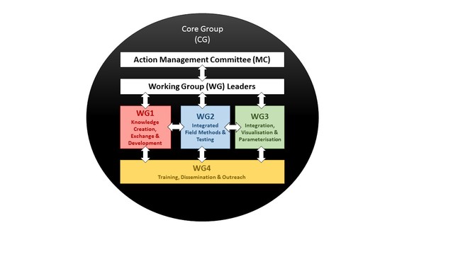
MANAGEMENT STRUCTURES AND PROCEDURES
Action Management Committee (MC): Will coordinate, supervise and manage the overall progress of the activities of the four WGs, ensure that milestones and deliverables are achieved and guarantee that COST policies are followed. The MC will maintain general oversight of SAGA’s overall structure, budget and the balanced participation from participating COST Countries. The MC is responsible for the submission of progress reports and the proper use of funds for networking activities. The MC will ensure strong interactions between WGs to ensure cross-fertilisation and stimulate cooperation with relevant COST Actions and other networks. It will be formed by members from all participating countries. MC members are expected to play a key role in the Action supervision, participate in meetings and act as intermediaries between the European, national, and regional academic communities, other national stakeholders and funding agencies. The MC will encourage active involvement of ECIs. Therefore, the MC should combine senior scientists and ECIs delegates. The MC is led by the Action Chair and Vice-Chair and they will take actions to enable proper decision making and ensure all efforts are focused to achieve SAGA’s objectives. The MC will meet once per year (unless the interest of the Action requires intermediate meetings). The Action Chair will be the reference point for SAGA, chair the annual meetings, responsible for the preparation of all scientific reports and the final report. The Action Chair will be elected during the First Management Committee Meeting. The Vice-Chair will also be elected through the MC. The Vice-Chair will primarily focus on practical issues (organisation of the Action).
Work Group (WG) Leaders: SAGA is structured into 4 WGs, each led by two members from different participating countries/research backgrounds. ECIs should be actively promoted to take the lead in the WGs. The WG Leaders will coordinate the WG networking and capacity building activities, stimulate STSMs, training and contacts with other WGs. They will be in charge of further subdividing the WGs into sub-groups, coordinating the progress of these and preparing the WG output for the MC reports (e.g. progress in relation to deliverables and milestones, any delays, etc). To this end, the WG Leader will periodically send reports to the Action MC and Core Group (CG).
Training, Dissemination and Administration Manager (TDA): will support the MC and WG Leaders in the management, organisation and administration of meetings, Training Schools and STSMs.
Technical & Media Manager (TM): technical preparations of meetings, responsible for website / online resources (databases & social media) and handling contact requests.
Core Group (CG): the constitution of a CG will be discussed during the First MC meeting. The Action MC has to approve the composition and mandate of the CG. The CG typically consists of the COST Action Chair, Vice-Chair, WG Leaders and other key leadership positions within SAGA deemed necessary by the Action MC.
NETWORK AS A WHOLE
This COST Action is proposed by researchers from 22 COST member states, including 11 Inclusiveness Target Countries (ITCs), 2 Near Neighbour Country (NNC) and 1 International Partner Country (IPC). With 32 proposers, this trans-disciplinary Action network connects scientific excellence with the relevant theoretical and applied knowledge to establish the state-of-the-art and develop standards for novel applications using integrated minimally invasive methods to explore and record archaeological sites and landscape across Europe.
SAGA’s Network of Proposers represents a diverse and high-profile group of world-leading researchers in, inter alia, archaeological prospection, geophysics, soils science, geoarchaeology, paleo-environmentalists with impressive publication records. These researchers form a critical scientific mass, range of expertise and geographical extent needed to start the Action, tackle the challenges and achieve its goals. A key aspect of the network is that it includes inspirational participants who are active in mentoring ECIs, supervising PhD students and teaching students across Europe. These key members will ensure that the goals and activities of SAGA will reach, engage and benefit the next generation of researchers in the early stages of the Action.
The network already incorporates a broad stakeholder coverage including public and private companies (currently 2 SMEs) with a strong track-record of successful collaboration. In addition, extensive collaborations with European cultural heritage institutions and societies, curators and planning officers will ensure that the deliverables of this Action will find entry into real-world archaeo-prospection and relevant legislation.
Although not all European countries are presently included in the Network of Proposers, we strive to actively include many more countries after the establishment of the Action. This will be done via: promotion on international conferences and mailing lists; relevant social media; through personal networks of the proposers.
SAGA also incorporates strategic partnerships with researchers and institutions from NNCs and an IPC, in order to ensure that relevant initiatives, methods and strategies being developed in other non-European countries are quickly detected. These connections will secure fast dissemination of research findings through their national representatives.
Grant title
COST Action SAGA (CA 17131)
Hosting institution
Norwegian University of Science and Technology (NTNU)
References
- Handbook of Agricultural Geophysics.CRC Press,Florida. https://doi.org/10.1201/9781420019353
- Mixed method approaches to the investigation and mapping of buried Quaternary deposits: examples from southern England.Archaeological Prospection14(2):104‑129. https://doi.org/10.1002/arp.303
- The use of FDEM in hydrogeophysics: A review.Journal of Applied Geophysics139:36‑46. https://doi.org/10.1016/j.jappgeo.2017.02.011
- Seeing the Unseen. Geophysics and Landscape Archaeology.CRC Press,London,276pp. [ISBN9780415447218] https://doi.org/10.1201/9780203889558
- Seeing Beneath the Soil: Prospecting Methods in Archaeology.Routledge,London,192pp. [ISBN9781134611218] https://doi.org/10.4324/9780203279304
- A multidisciplinary approach to reconstructing Late Glacial and Early Holocene landscapes.Journal of Archaeological Science40(2):1260‑1267. https://doi.org/10.1016/j.jas.2012.09.004
- Assessment of multiple geophysical techniques for the characterization of municipal waste deposit sites.Journal of Applied Geophysics145:74‑83. https://doi.org/10.1016/j.jappgeo.2017.07.013
- Occurrence of magnetic bacteria in soil.Nature343(6254):161‑163. https://doi.org/10.1038/343161a0
- Integrating multidimensional geophysical data.Archaeological Prospection13(1):57‑72. https://doi.org/10.1002/arp.268
- Best Practices of GeoInformatic Technologies for the Mapping of Archaeolandscapes.Archaeopress Publishing Ltd,Oxford,269pp. [ISBN9781784911621]
- EAC Guidelines for the use of Geophysics in Archaeology: Questions to Ask and Points to Consider.EAC Guidelines 2.Europae Archaeologia Consilium (EAC),Namur,135pp. URL: http://hdl.handle.net/10454/8129 [ISBN978-963-9911-73-4]
- Archaeological Prospecting and Remote Sensing.Cambridge University Press,Cambridge & New York,674pp. [ISBN0-521-32050]
- Slingram EMI prospection: Are vertical orientated devices a suitable solution in archaeological and pedological prospection?Journal of Applied Geophysics75(4):731‑737. https://doi.org/10.1016/j.jappgeo.2011.10.002
- Efficient, large-scale archaeological prospection using a true three-dimensional ground-penetrating Radar Array system.Archaeological Prospection17(3):175‑186. https://doi.org/10.1002/arp.381
- Alluvium and geophysical prospection.Archaeological Prospection8(4):265‑272. https://doi.org/10.1002/arp.160
- Soil and susceptibility: aspects of thermally induced magnetism within the dynamic pedological system.Archaeological Prospection9(4):207‑215. https://doi.org/10.1002/arp.196