|
Research Ideas and Outcomes : Grant Proposal
|
|
Corresponding author: Thibault Datry (thibault.datry@irstea.fr)
Received: 20 Oct 2017 | Published: 01 Nov 2017
© 2018 Thibault Datry, Gabriel Singer, Eric Sauquet, Dídac Jorda-Capdevila, Daniel Von Schiller, Rachel Stubbington, Claire Magand, Petr Pařil, Marko Miliša, Vicenç Acuña, Maria Helena Alves, Bénédicte Augeard, Matthias Brunke, Núria Cid, Zoltán Csabai, Judy England, Jochen Froebrich, Phoebe Koundouri, Nicolas Lamouroux, Eugènia Martí, Manuela Morais, Antoni Munné, Michael Mutz, Vladimir Pesic, Ana Previšić, Arnaud Reynaud, Christopher Robinson, Jonathan Sadler, Nikos Skoulikidis, Benoit Terrier, Klement Tockner, David Vesely, Annamaria Zoppini
This is an open access article distributed under the terms of the Creative Commons Attribution License (CC BY 4.0), which permits unrestricted use, distribution, and reproduction in any medium, provided the original author and source are credited.
Citation: Datry T, Singer G, Sauquet E, Jorda-Capdevilla D, Von Schiller D, Stubbington R, Magand C, Pařil P, Miliša M, Acuña V, Alves M, Augeard B, Brunke M, Cid N, Csabai Z, England J, Froebrich J, Koundouri P, Lamouroux N, Martí E, Morais M, Munné A, Mutz M, Pesic V, Previšić A, Reynaud A, Robinson C, Sadler J, Skoulikidis N, Terrier B, Tockner K, Vesely D, Zoppini A (2017) Science and Management of Intermittent Rivers and Ephemeral Streams (SMIRES). Research Ideas and Outcomes 3: e21774. https://doi.org/10.3897/rio.3.e21774
|
|
Abstract
More than half of the global river network is composed of intermittent rivers and ephemeral streams (IRES), which are expanding in response to climate change and increasing water demands. After years of obscurity, the science of IRES has bloomed recently and it is being recognised that IRES support a unique and high biodiversity, provide essential ecosystem services and are functionally part of river networks and groundwater systems. However, they still lack protective and adequate management, thereby jeopardizing water resources at the global scale. This Action brings together hydrologists, biogeochemists, ecologists, modellers, environmental economists, social researchers and stakeholders from 14 different countries to develop a research network for synthesising the fragmented, recent knowledge on IRES, improving our understanding of IRES and translating this into a science-based, sustainable management of river networks. Deliverables will be provided through i) research workshops synthesising and addressing key challenges in IRES science, supporting research exchange and educating young researchers, and ii) researcher-stakeholder workshops translating improved knowledge into tangible tools and guidelines for protecting IRES and raising awareness of their importance and value in societal and decision-maker spheres. This Action is organized within six Working Groups to address: (i) the occurrence, distribution and hydrological trends of IRES; (ii) the effects of flow alterations on IRES functions and services; (iii) the interaction of aquatic and terrestrial biogeochemical processes at catchment scale; (iv) the biomonitoring of the ecological status of IRES; (v) synergies in IRES research at the European scale, data assemblage and sharing; (vi) IRES management and advocacy training.
Keywords
Flow intermittence, river networks, water scarcity, hydrological modelling, e-flow management, ecological status assessment, climate change, conservation, management, citizen-science, Water Framework Directive.
Science and Technology Excellence
Challenge
Description of the Challenge (Main Aim)
Traditional flow-gauging systems have vastly underestimated the number of rivers and streams flowing intermittently (Fig.
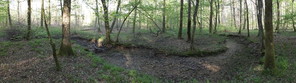
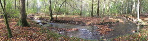
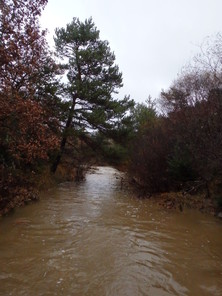
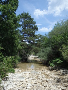
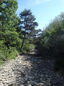
Two examples of IRES during contrasting hydrological phases.
b: The Clauge River in the temperate Jura, France, during flowing phase
c: The Calavon River in Mediterranean during flowing phase
d: The Calavon River in Mediterranean during dry phase
e: The Calavon River in Mediterranean during dry phase
Historically, IRES have been perceived to be outside of the scope of both terrestrial and aquatic sciences (Fig.
IRES are now known to support high and unique biodiversity, important ecosystem processes, and provide valuable goods and services (
IRES are being degraded at alarming rates due to hydrologic alteration, including water extraction, flood harvesting, and river impoundment, channel modification, land-use change, and mining (
While the understanding and recognition of IRES is blooming in academia (
- to locate, map and predict IRES within river networks, spatialize flow intermittence patterns and describe their pulsed regimes, explore historical evolution of these patterns, distinguish natural from anthropogenic IRES, and identify areas at risk of increasing flow intermittence (
Datry et al. 2011 ,Snelder et al. 2013 ,Prat et al. 2014 ); - to establish the ecosystem services provided by IRES and understand their responses to flow regime alterations, thereby allowing definition of environmental flows in IRES.
- to understand carbon and nutrient dynamics at the catchment scale in these pulsed systems, where accumulation of organic material and nutrients during dry phases causes pronounced peaks in downstream export during early flowing phases, with potentially deleterious effects on water quality (
Datry et al. 2014 ). - to disentangle the effects of flow intermittence on river communities from the effects of other stressors, such as urbanisation, agriculture, etc. Most community metrics used in biomonitoring respond negatively to increasing flow intermittence (e.g.
Prat et al. 2014 ,Datry et al. 2013 ,Morais et al. 2004 ,Habets et al. 2014 ) and are inadequate for IRES in the context of the Water Framework and Habitats Directives (Acuna et al. 2014 ).
The challenge of the Action is to concentrate and refine the currently sparse and fragmented knowledge on IRES with the aim of supporting the incorporation of these prevalent and unique ecosystems into current water resource and biodiversity management and conservation plans. To do so, the Action will join scattered research activities in nationally funded research projects across COST Member countries and COST Near Neighbour countries, and those in past and ongoing European and internationally funded projects. The Action will facilitate sharing of data and experience, bring together researchers of many disciplines and stakeholders and create synergies through networking. The ultimate aim is a substantial advancement of the knowledge and management of IRES throughout Europe through a unifying conceptual framework and robust, tangible tools and guidelines.
In this interdisciplinary approach, researchers and stakeholders with scientific and management expertise on IRES in different contexts (humid, temperate, Mediterranean, arid) from 14 countries (i.e. 12 COST Members, including 3 Inclusiveness Target Countries (ITC), 1 Near Neighbour Country (NNC) and 1 Cooperating State) will:
- Address specific challenges, limitations and potentials of IRES management (see 1-4 above);
- Develop a scientific conceptual framework for IRES based on recent research knowledge from field and laboratory studies and current network activities;
- Identify areas at risk of increased flow intermittence;
- Evaluate the socio-economic value of natural IRES;
- Identify the impacts of increasing flow intermittence on river ecosystem function and service;
- Identify research needs, including interdisciplinary efforts;
- Raise awareness in societies and relevant decision-making spheres about the importance of IRES.
Relevance and timelines
Although IRES make up a high proportion of river networks in many European regions, they have been understudied for a long period. However, recent research on IRES has provided evidence about the high and unique biodiversity they host, the relevance of their contribution on the control of energy and matter fluxes along the fluvial networks, and their provision of valuable goods and services for society. In addition, IRES have been consistently and widely misconsidered in management and protection strategies and directives, mostly because in most countries, the legislative definition of a “river” implies perennial flows. Recently passionate debates have been challenging this definition, recognizing that IRES are not only essential to riverine biodiversity and biogeochemical functions, but also to the ecology of adjacent wetlands, riparian zones and floodplains. Therefore, the compilation and synthesis of the existing knowledge and data on IRES from this consortium, as proposed in this Action, will strongly contribute to fill this historical gap on the preservation and amelioration of freshwater bodies, as currently considered in the EU Water Framework and Habitats Directives, and ultimately increase the social and political value for these ecosystems, which are a key water resource in many European regions In addition, characteristics of IRES may expand into currently still perennial European streams due to the foreseen patterns of global change (higher human water demand and climate change). These changes are expected to increase the number and length of IRES and to dry up today’s perennial systems, resulting in dramatic alterations of flow regimes. This is not about a future condition, data shows that it is already happening (
Objectives
Research Coordination Objective
This COST Action aims to develop a multidisciplinary network of scientists and stakeholder representatives and experts on IRES from 14 countries to consolidate and expand the current understanding of IRES and translate it into science-based, sustainable management of IRES resources and biodiversity.
The Action has four main coordination objectives:
- To create an extensive research network across river researchers from multiple disciplines to promote the sharing of data and experience and the setup of common experiments;
- To link researchers with stakeholders to translate current knowledge about IRES into robust, tangible tools and guidelines for improved management and conservation practices and rules;
- To link current on-going research efforts on IRES at the European scale and create synergies for further research;
- To raise social awareness about the values of IRES and train a new generation of researchers.
Capacity-building Objective
The objectives of the Action in terms of capacity building are:
- to support data sharing, and the creation of 2 meta-databases containing: 1) details of all past and ongoing IRES research efforts across the participants, and beyond, and 2) details of flow gauging stations with zero flows at the European scale;
- to closely associate researchers and stakeholders and generate synergies at the European scale;
- to train a new generation of Early Stage Researchers (ESRs), provide them with a significant network platform, and create a Forum of Young Researchers (FYR);
- to support, in particular for ESRs, visits to participating research institutions within the network for training on targeted technical or methodological aspects.
Progress beyond the state-of-the-art and Innovation Potential
Description of the state-of-the-art
The first challenge (C1) is to locate, map and predict IRES in river networks, spatialize flow intermittence patterns, explore historical evolution of these patterns, and distinguish natural and anthropogenic IRES. Hydrological datasets are produced for and from perennial rivers, and they consequently ignore or misrepresent IRES (
The second challenge (C2) is to understand how alterations in flow regimes impair IRES biodiversity, functions and services, and consequently, how to define environmental flows in IRES. Flow alterations have been studied mostly in perennial rivers and their effects on IRES functioning and services are poorly known (
The third challenge (C3) is the modelling of carbon and nutrient dynamics in IRES at the catchment-scale. IRES are typically pulsed systems, where accumulation of organic material and nutrients during dry phases is followed by pronounced downstream export peaks during early flowing phases, with potential deleterious effects on water quality (
Fourth and finally, disentangling the effects of flow intermittence on river communities from those of other stressors is an essential challenge to improve our understanding of the biodiversity of IRES and develop sound biomonitoring approaches (C4). Current bioindicators used for assessing the ecological status of rivers in Europe cannot be applied in IRES, as most species indicative of alterations are also very sensitive to drying (e.g.
Progress beyond the state-of-the-art
The Action will develop a robust ecohydrological framework and will use novel and unique approaches to tackle the 4 challenges. Due to the central role that hydrology plays in setting the characteristics of IRES, C1 will produce the physical, hydrological basis on which C2, C3 and C4 will be addressed. This will ensure scientific robustness and put the Action in the emerging but already well-recognised discipline of ecohydrology. In addition, the geographic coverage of the participants will for the first time span oceanic, temperate, continental, Mediterranean, and arid climate zones, hereby covering a wide range of situations. Moreover, involving both scientists and stakeholders will allow identification of the management problems and needs and will address these problems by generating tangible tools for improving IRES management.
C1 will be addressed using various approaches, some of them being novel and unique in this field. The first step will involve collating all continuous hydrological data and associated climatic (e.g. temperature, rainfall) and catchment-scale (e.g. geology, topography, vegetation) data available across the participating countries and producing a meta-database. Regionalisation procedures will be used to predict drying risk at catchment scales and trend analyses will identify areas at risk of increasing drying (i.e. sentinel catchments). Maps of IRES in the participating countries will be produced, and the very first hydrological classification of IRES at the European scale will be generated to identify key hydrological variables and drivers. In addition to these major advancements, novel approaches coupling aerial photography, citizen science initiatives and social sciences will be tested and developed. For example, for areas where data are scarce or fragmented, aerial unmanned vehicles (AUVs) and satellite images will be used to locate drying sections (
C2 will be tackled by examining available information on the biological and functional responses to flow variability in IRES and synthesizing this information in a conceptual model from which flow management strategies can be developped. A meta-database compiling available information from participating members will synthesize this information. IRES ecosystem services will be established and economically quantified, along with their links to flow regimes. These actions aim to contribute to environmentally sound flow management in IRES.
C3 will be addressed by a meta-ecosystem modelling approach, which will couple terrestrial and aquatic models of carbon and nutrient cycling at the catchment scale for different IRES. The sharing of scientific information about carbon and nutrient dynamics during dry and flowing phases among members, together with a deep literature review, will be a key step towards meeting this challenge. This data synthesis will be complemented by modelling techniques to explore the influence of spatial and temporal patterns of drying on carbon and nutrient dynamics in IRES and to compare them to patterns from perennial streams. This will improve our understanding of the extent to which processes in dry phases influence water quality during flowing phases and will help to refine current estimates of the contribution of river systems to carbon processing at the global scale.
To address C4, the different bioindicators developed for perennial rivers will be adapted for IRES. Meta-analyses examining the occurrence of different species across gradients of flow intermittence will allow assignment of a score of “sensitivity to flow intermittence” to each taxon. These scores will be validated using the expertise, data, and knowledge shared among the participants. This approach will be tested in many case studies from the different participating countries, including targeted catchments from relevant past European projects. When validated, the adapted biomonitoring tools will be delivered to stakeholders though an electronic handbook including guidelines and caveats.
Innovation in tackling the challenge
The proposed Action is innovative in its provision of:
- a meta-database based on a compilation of existing scientific knowledge on IRES at the European level and beyond;
- a meta-database of flow indicators for IRES based on data from gauging stations and heuristic knowledge from stakeholders at the European level;
- a review of existing knowledge and management needs for IRES based on intertwined researcher and stakeholder working discussions;
- a conceptual framework for IRES based on an ecohydrological approach;
- a revised compilation of ecosystem services of IRES with quantified data;
- a coupled aquatic and terrestrial model to understand carbon and nutrient dynamics across IRES;
- a proposal of novel indicators and technologies (e.g. aerial unmanned vehicles, smartphones) to assess changes and associated ecological responses in IRES;
- tangible tools and science-based guidelines for managing IRES in Europe.
Added value of networking
In relation to the Challenge
The Action will achieve its objectives by:
creating an interdisciplinary network of knowledgeable river researchers in order to promote data and experience sharing and a new generation of experiments and projects on IRES;
- creating two European-scale meta-databases;
- creating a collaborative effort between researchers and stakeholders from the participating countries;
- organizing topical and interdisciplinary workshops involving relevant researchers, to address the current state of knowledge, identify research gaps, explore potential opportunities for and limitations of IRES management and conservation, develop a unifying conceptual framework to organize and guide further joint efforts, and translate current knowledge into tools and guidelines for water resource managers;
- organizing Research To Management Workshops (RTMW) linking relevant researchers and stakeholders to share experiences, management limitations and needs, and to transmit the tools and guidelines produced during the Action.
- organizing Training Schools (TS) dedicated to the training of ESRs related to both fundamental and applied scientific aspects of IRES research;
- establishing a FYR to generate a European network for early career researchers, with smaller topical FYR workshops being organized;
- favouring Short-Term Scientific Missions (STSM), in particular for ESRs, to visit participating research institutions within the network for training on targeted technical or methodological aspects;
- producing at least 4 perspective papers on IRES, corresponding to each of C1-4;
- organizing Special Topical Sessions (STS) at 4 international conferences, focusing on the outputs of the Action;
At present, there are no joint efforts providing networking to synthesise knowledge and link research to management of IRES at the European scale. Incorporating IRES into current water resource management plans is a key challenge, as recently highlighted in a Science policy paper (
In relation to existing efforts at European and/or international levels
This Action will complement and expand the achievements initiated by two previous European programs, to model water quality (TempQsim, 2002-2006) and improve management (MIRAGE, 2009-2011) of Mediterranean rivers. The Action will also build on several ongoing activities in Europe, such as the analysis of the effects of multi-stressors in rivers under water scarcity (European projects GLOBAQUA and MARS), the development of software to improve the management of Mediterranean rivers (Life+ project TRivers), and international initiatives, such as the global analysis and synthesis of IRES biodiversity information (International collaborative project IRBAS). Yet, at present, there are no programs or existing networks in Europe seeking to advance the science of IRES and to link up-to-date knowledge to management practices and guidelines.
This Action involves experts from most past and current national and European-funded projects related to IRES. This ensures that this Action will function as a unique platform for forum discussion, development of new ideas, and exchange between scientific and heuristic knowledge and needs at the European level. The Action is expected to complement research actions developed under European Horizon 2020.
Impact
Expected Impact
Short-term and long-term scientific, technological, and/or socio-economic impacts
The results of this Action are essential to support current initiatives on the ecological understanding of IRES through empirical and modelling approaches, as well as to propose monitoring programmes and management and protection strategies based on knowledge of IRES communities, functions and ecosystem services. This will be achieved by the funded network of scientists and stakeholder experts on IRES within this Action.
The Action will have direct relevance at national, European (and international) levels by providing tangible tools, indicators and guidelines for integrating IRES into current management programmes and existing directives (Water Framework Directives, Habitats Directives). Moreover, additional policy-oriented structures, organizations and consultancies focusing on natural resource management, biodiversity and ecosystem services supported by rivers will benefit from this Action by expanding the current scope of river management by incorporating regimes and dynamics of IRES, which will become a more widespred ecosystem feature in future years.
The scientific and applied innovative perspective of this Action will contribute to:
- Scientific integration and visibility of European experimental research: The Action will establish short- and long-term intertwined research efforts and close collaboration with national, European and international research networks, thereby favouring the visibility of European research communities in the hot topic of IRES;
- Data sharing: The Action will produce 2 meta-databases. This will undoubtedly promote short- and long-term synergies among researchers from European and non-European countries. In addition, the Action will promote the creation of a citizen-science network to monitor river flow states and overcome the current lack of hydrological data. This effort will continue beyond the end of the Action.
- Improving river resource management: An electronic handbook containing management guidelines derived from the 4 challenges will be produced.
- Outstanding scientific position papers: The Action will produce > 4 perspectives papers outlining cutting-edge research and proposing future research needs within its overall area and the specific objectives;
- Raising social and political awareness of IRES importance: The Action will promote the importance of IRES at the European scale both within the scientific and management communities through workshops, STSM, TS, and RTMW activities. The economic quantification of IRES ecosystem services and the citizen-science network will also contribute to a better recognition of IRES by society.
- Improved use of research facilities: The Action will support STSM and between-country access to research facilities by other researchers, especially by ESR;
- Education of a new generation of river researchers in IRES: The Action will provide training for young researchers through workshops, STSM, TS, and the FYR.
- Provide guidelines and information to water resource consulting companies: The electronic handbook will provide regulatory agencies and consultancies, which are largely unfamiliar with IRES, tools and guidelines to promote inclusion of IRES in environmental investigations.
The results of this Action are essential to support current initiatives to understand the monitoring, prediction, modelling, management and protection of IRES and their associated communities, functions and ecosystem services. The scientific community participating in nationally funded projects across Europe, and also from current and past specific European projects such as MIRAGE and GLOBAQUA, will have a very strong interest in the activities of the Action. The Action will have direct relevance for both national, European and international water resource managers and policymakers, who will benefit from the translation of current knowledge into tangible tools and guidelines for integrating IRES into current water resource management plans and practices. Moreover, additional policy-oriented structures, organizations and consultancies focusing on natural resource management, biodiversity and ecosystem services supported by rivers will be greatly interested in this Action.
Measures to Maximise Impact
Plan for involving the most relevant stakeholders
The aim of the Action is precisely to proactively involve stakeholders in the synthesis of efforts to locate and characterize IRES, identify the associated management problems, and how to tackle them. For this reason, stakeholders from each participating country (e.g. Water Agencies, Basin Committees, Ministries, and Consultants) will actively participate in the different tasks of this Action. To reach these objectives, reciprocal exchanges and intertwined workshops between researchers and stakeholders are included throughout the Action.
Dissemination and/or Exploitation Plan
The Action outputs will be disseminated through:
- Outstanding scientific papers, including a key synthesis paper on IRES management;
- One electronic handbook with guidelines for IRES management;
- Publicly available meta-databases on IRES research activities, experiments and projects, as well as a meta-database of flow stations with intermittent flows across the participating countries;
- A website of the Action which will be updated;
- The organisation of 4 STS at 4 international conferences;
- The organisation of 3 RTMWs during which water resource managers from participating countries will be invited to share experiences, limitations, ideas, and concerns, and to discuss the tools and guidelines produced during the Action;
- The organisation of TS dedicated to the training of ESRs in both fundamental and applied scientific aspects of IRES research;
- The establishment of a FYR to generate a European network for young researchers;
- STSM to visit participating research institutions within the network for training on targeted technical or methodological aspects;
- This Action will lead to the preparation of a European research project and one or more ITN/ETN (Innovative / European Training Networks) proposals.
Potential for Innovation versus Risk Level
Potential for scientific, technological and/or socio-economic innovation breakthroughs
Large-scale maps of IRES locations are lacking in most countries. Development of these maps based on openly accessible GIS are key to evaluating the extent of IRES within different European countries within this Action.
In addition, identification of sentinel IRES sites within the Action and planning for focussed research based on knowledge gaps will provide an effective approach to develop science-grounded decisions not only in water resource management and nature conservation (e.g. restoration of flow regimes, adaptation to climate change), but also in the water quality regimes characteristic of IRES.
The use of novel technologies (e.g., AUVs and smartphones) to help convince citizens of the value of IRES and to overcome the lack of information about IRES location and distribution. This Action will promote the use of such techniques to increase awareness and perceived value of IRES at societal levels.
Implementation
Description of the Work Plan
Description of Working Groups – Provide for each WG the Objectives, Tasks, Milestones and Deliverables
The Action is organized in 6 Working Groups (WGs) that build upon each other to develop a global framework. Four WGs are science-driven, corresponding to the 4 challenges of the Action; 1 WG is dedicated to networking activities; and 1 to dissemination and capacity-building activities.
WG 1: Prevalence, distribution and trends of IRES
Objectives. Compile hydrological data to locate, map and analyse trends in flow intermittence in IRES; spatialize flow intermittence patterns in selected catchments, explore historical evolution of these patterns, develop a citizen-science monitoring network.
Tasks. Define terms and adopt a consistent terminology; pool together all continuous hydrological data and associated climatic (e.g. temperature, rainfall) and catchment-scale data (e.g. geology, topography) available in the participating countries; conduct reviews and syntheses and trend analyses to identify areas at risk of increasing drying (i.e. sentinel catchments) in response to climate change; produce maps of IRES; generate a hydrological classification of IRES at the European scale; use novel approaches to locate IRES combining airborne photography using aerial unmanned vehicles, a citizen-science network and social science approaches (e.g. exploring the memories of local people in key areas to extract additional information about drying history); explore IRES drivers in key catchments and differentiate natural and anthropogenic IRES; develop a European-scale network of citizen scientists to locate, map and monitor river flow states using smartphones; produce a hydrological meta-database.
Milestones. WG1 will organise 1-2 annual workshops, including one with WG5 and WG6.
Deliverables. Workshop minutes; meta-database of continuous flow data; maps of IRES at the European scale; identification of sentinel areas; a European-scale network of citizen scientists to monitor river flow states; a continuously developing database of drying occurrence across European river networks.
WG 2: Flow alterations, ecosystem services and management of IRES
Objectives. Quantify the functions and ecosystem services provided by IRES and explore their responses to flow alterations; define rules for flow management in IRES.
Tasks. Establish the functions and services provided by IRES; quantify their economic value; explore their relationships with flow regime components and alterations by connecting currently fragmented knowledge across the participating countries; produce a meta-database of past and ongoing scientific projects in IRES; develop an ecohydrological conceptual framework to guide management of flows in IRES.
Milestones. WG2 will organise 1-2 annual workshops, including one with WG1, WG5 and WG6.
Deliverables. Develop a conceptual ecohydrological framework for IRES; compile existing knowledge on IRES functioning and on the flow regime as a controlling factor; identify critical ecosystem services and evaluate their economic value; generate guidelines for managing flows in IRES based on the outputs of these tasks.
WG 3: Coupled aquatic-terrestrial biogeochemistry in IRES
Objectives. Couple aquatic and terrestrial models to predict carbon and nutrient dynamics in IRES at the catchment scale; guide management and physico-chemistry sampling schemes
Tasks. Couple aquatic and terrestrial models of carbon and nutrient cycling at the catchment-scale and for different IRES; conduct meta-analyses to estimate rates of storage, processing and export in flowing and dry phases; link with the spatial and temporal hydrological information compiled in WG1; explore the influence of terrestrial processes on water quality during flowing phases; refine current estimates of how much river systems process carbon and nutrients at the global scale.
Milestones. WG3 will organise 1-2 annual workshops, including one with WG1, WG5 and WG6.
Deliverables. Meta-models of carbon and nutrient dynamics in IRES at the catchment scale; improved understanding of the respective influence of aquatic and terrestrial biogeochemical processes on IRES water quality; refined European-scale estimates of carbon and nutrient processing in rivers; guidelines for management sampling schemes.
WG 4: Bioindication of IRES
Objectives. Adapt current biomonitoring methods for IRES; produce an electronic handbook including guidelines and caveats for IRES biomonitoring.
Tasks. List the different bioindicators and protocols used in the participating countries to assess the ecological status of rivers, including IRES when relevant; review management practices in countries outside of Europe (e.g. Australia, South Africa); identify issues and limitations; conduct meta-analyses to examine the occurrence of the different taxa across gradients of flow intermittence and assign a score of “sensitivity to flow intermittence” to each taxon; combine expertise, data, and knowledge shared among the participating countries; test and validate the refined bioindicators on documented case studies (>40), including on the case-study catchments of the MIRAGE and TRivers projects; deliver to stakeholders an electronic handbook including guidelines and caveats.
Milestones. WG4 will organise 1-2 annual workshops, including one with WG5 and WG6.
Deliverables. Bioindication tools for assessing IRES ecological status; electronic handbook including guidelines and caveats.
WG 5: Networking
Objectives. to build the network; to link past and ongoing research projects to IRES; to share experience and information; to synthesize the state-of-the-art and knowledge gap analysis of IRES; to ensure active participation of stakeholders.
Tasks. To organise annual topical and cross-disciplinary workshops; address the challenge of providing open information on projects and experiments, to facilitate sharing of data and results for general synthesis; meta-analyses and modelling; create a stakeholder committee and ensure continuous exchanges between researchers and stakeholders.
Milestones. WG5 will organise annual workshops with all WGs, and several smaller workshops for WG1, 2, 3 and 4 on specific networking aspects.
Deliverables. Workshop minutes; synthesis of state-of-the-art and knowledge gap analysis of IRES.
WG 6: Dissemination and capacity-building
Objectives. To disseminate the scientific activities; to train ECIs and stakeholders; to promote STSM; to deliver the tools and guidelines to stakeholders; to ensure visibility of the Action at the international scale.
Tasks. Organise workshops to produce perspective papers for each of the 4 scientific tasks described above (WG1-4); organize 2-3 TS for ECIs on IRES encompassing the 4 disciplines represented; offer training sites as part of the Short-Term Scientific Mission program (>10 STSMs); organise dedicated technical workshops with water resource managers and policymakers; develop an interactive website providing information on activities, key findings, document repository, data sharing platform and information from other relevant activities; use social networks (e.g. Twitter, Facebook) to disseminate progresses; organise STSs on IRES at 4 international conferences in collaboration with other international networks; produce a Special Issue (SI) in one international journal on IRES management aspects; deliver guidelines to stakeholders.
Milestones. WG6 will organise annual workshops to produce key papers; organisation of 4 TS during the Action; STSM program management, website creation and update; STS organisation; SI production.
Deliverables. Electronic handbook including guidelines for stakeholders of each participating country; STS at 4 international conferences; dedicated workshops with water resource managers and policymakers; annual workshops on WG specific topics for a smaller audience, eventually in relation to annual conferences (4 workshops minimum); 3 TS on IRES hydrology, biogeochemistry, ecology and modelling will be targeted specifically at ECIs with both theoretical and applied aspects (e.g. fieldwork); STSMs – each WG will provide announcements of STSMs. The priority will be given to STSMs for data analysis and interpretation involving ECI, related to the development of the Action area and with publication potential (>10 STSM).
GANTT Diagram
See Table
GANTT Diagram
|
YEAR1 Months 1-6 |
YEAR1 Months 6-12 |
YEAR2 Months 1-6 |
YEAR2 Months 6-12 |
YEAR3 Months 1-6 |
YEAR3 Months 6-12 |
YEAR4 Months 1-6 |
YEAR4 Months 6-12 |
|
|
MC meetings |
X |
X |
X |
X |
X |
|||
|
Visio conferences (MC, GC, SHC, |
X |
X |
X |
X |
X |
X |
X |
X |
|
WG workshops |
X |
X |
X |
X |
X |
X |
X |
X |
|
Website |
X |
X |
X |
X |
X |
X |
X |
X |
|
STSM |
X |
X |
X |
X |
X |
X |
X |
|
|
TS |
X |
X |
X |
X |
||||
|
FYR meetings |
X |
X |
X |
|||||
|
RTMW |
X |
X |
X |
|||||
|
STS |
X |
X |
X |
X |
||||
|
Meta-database release |
X |
X |
X |
X |
||||
|
Papers |
X |
X |
X |
X |
||||
|
Electronic handbook |
X |
X |
||||||
|
Citizen-scientist network |
X |
X |
X |
X |
X |
Risk and Contingency Plans
Risks on the Action level will be overseen by the Coordinator who will use established methods for project planning and control. Initial risks were identified with respect to:
- partnerships (e.g., partner fails to provide access to resource or to assist in workshop);
- project management (e.g., too high work load for individual partners);
- methodological issues (e.g., failure to provide essential data with a specific method); or
- the time plan (e.g., delay of producing deliverables).
Risk management will be a continuous process under the charge of the Coordinator and a Core Group (CG), with risks systematically identified at each workshop and mitigation measures initiated as required.
Disputes will be resolved in accordance with a clearly defined process:
- A solution in agreement with the objectives of all parties is aimed for;
- the dispute should be resolved at the appropriate level, with all discussions conducted in an open and honest manner.
In case of a dispute, the Coordinator shall be immediately informed and will assess the potential effect of the dispute on the entire project, and following consultation with experts of the IRSTEA International Research Direction and the CG, will decide on the appropriate approach for resolving the dispute. This may be achieved by local intervention or, in extreme cases, by calling an emergency meeting where possible courses of action can be discussed and voted upon.
The WG leaders will assemble and regularly update a Risk Statement Form which describes each risk and its threat to the Action. The Coordinator will then assign the issue to a partner or a group of partners who will then actively work on a resolution. The status of the resolution will be tracked by the Coordinator. After resolving an issue, the process will be documented and shared among the consortium. In case of major problems or delays the Coordinator will immediately communicate with the consortium to ensure that corrective actions are agreed upon and implemented at an early stage.
Management structures and procedures
Management structures – The organisation and management of the Action will consist of the following entities:
Management Committee (MC): The MC will be responsible for the overall coordination of the Action through annual meetings and regular contact with WG Leaders.
Core Group (GC): The GC will be a subset of the MC in charge of monitoring progress and ongoing matters (including risks and disputes).
Stakeholder Committee (SHC): The SHC will represent the stakeholders from the different participating countries. It will have annual meetings and permanent contacts with the MC, GC and WG Leaders.
Working groups (WG): 6 WGs will form the basis of the Action. A WG Leader and Vice Leader will be responsible for the WG specific activities such as workshops, Training Schools and Short-Term Scientific Missions.
Short-Term Scientific Mission (STSM) panel: The Action is determined to strongly promote training of young researcher for example through STSM support. The STSM panel will include a delegate from each WG and will manage and evaluate STSM applications. An STSM Coordinator will be elected.
Forum of Young Researchers (FYR): An informal FYR will be created by the ECI participating to the Action and Training Schools. A leader will be nominated by the FYR.
Meetings and communication – A number of meetings and communication activities will be organised to ensure the activities and networking occur. These are:
Workshops: The Action will organise three sets of workshops.
- Annual international workshops (hosted by participants in the Action) bringing together a wide community of researchers to present the state of the art and outline future research needs related to the COST Action area.
- Smaller (15-30 people) WG-specific topical workshops targeted at the deliverables of the WG.
- RTMW workshops organised by SHC/MC and targeted at linking the activity of the Action to the water resource manager and decision-making communities, and delivering to them the produced tools and guidelines.
At least 10-20% of ECI participation will be obligatory in all workshops (except the RTMW ones). The WG workshops will be encouraged to produce a high-level perspective paper every 2 workshops.
MC meetings: Each year the MC will meet separately to discuss and decide on the progress of the Action, WGs, deliverables and future activities. The MC will specifically discuss potential collaborations and actions that each MC member should take forward to guarantee the transfer of knowledge at national levels, e.g. in relation to annual workshops.
Core Group (GC) visio-conference meetings: These meetings will be held 4 times each year to discuss progress and ongoing matters.
Stakeholder Committee (SHC) visio-conference meetings: These meetings will be held twice a year to discuss progress and ongoing matters.
Website: The Action will establish a website to describe/inform its activities as well as activities of relevance to participating members (meetings, conferences, TS, publications, etc.). The MC will consider the establishment of the Action profile in social networks like Facebook and/or Twitter to promote a continuous dialogue with interested parties.
Milestones - the progress of the Action will be assured through observing the following milestones:
First MC meeting: The first MC meeting at the beginning of the Action, which will involve agreeing on the constituency of the MC and GC, the Election of the Chair, Vice-Chair, Working Group (WG) Leaders, FYR Leader and STSM and RTM panels.
Website: The interactive website for the Action will provide information on the Action’s networking activities.
Annual workshops: A draft plan for annual Action workshops including MC, CG meeting, as well as WG and RTM workshops will be outlined at the first MC meeting. Annual workshop will be outlined one year in advance, including election of an organizing committee. The topical WG workshops will be suggested to the MC for approval 6 months in advance.
Training Schools: Grand plans for Training Schools (content, venue, size, budget) must be presented for discussion and decisions by the MC at the 2nd annual workshop.
Position papers: Plans for position papers and responsible lead authors will be decided at the 2nd annual workshop based on proposals from each WG.
Conferences: A grand plan for international conferences and organisation of STS will be organized at the first MC meeting.
The Action and its collaborators will be outlined at the first MC meeting and decided in more detail at the 2nd annual meeting.
Network as a whole
The consortium has several features which are critically relevant to address the objectives and challenges of the Action. First, the consortium is composed of many of the most knowledgeable researchers on IRES in Europe, leading IRES research in their country. Most of the participants are also working closely with water managers and stakeholders. The consortium includes three international leaders in the field from three different countries, who published IRES papers in very high-profile journals recently. The geographic coverage of the participants extends from Western, Central, Eastern to Southern Europe, spanning oceanic, temperate, continental, Mediterranean, and arid climate zones, hereby covering a wide range of situations and issues.
The inclusion of NNCs and ITCs will increase the geographical scope of the Action, notably by including countries of the Balkan Peninsula, hotspots of biodiversity where IRES predominate. The participation of IRES experts from 4 International Partner Countries (USA, New Zealand, South Africa, Australia) with whom several participants of the consortium have ongoing and efficient collaborations will provide scientific and management expertise, experience and training to the Action participants. This will notably include the invitation of several international experts to the TS but also the participation of managers from countries where the management of IRES is most advanced (e.g., Australia) to some RTMW to gain from their experience and share the Action challenges and progress. This will clearly benefit from past and ongoing collaborations that many participants have with colleagues outside of Europe.
The intertwined collaboration in the Action between researchers and managers will be crucial to achieve its goal, translating current knowledge into management tools and guidelines.
Funding program
European Cooperation in Science & Technology program (EU COST)
Grant title
Science and Management of Intermittent Rivers and Ephemeral Streams (SMIRES)
Hosting institution
IRSTEA Lyon, IGB Berlin
References
-
Why Should We Care About Temporary Waterways?Science343(6175):1080‑1082. https://doi.org/10.1126/science.1246666
-
An expanded role for river networks.Nature Geoscience5(10):678‑679. https://doi.org/10.1038/ngeo1593
-
Conservation of ephemeral streams and their ecosystem services: what are we missing?Aquatic Conservation: Marine and Freshwater Ecosystems24(6):733‑738. https://doi.org/10.1002/aqc.2537
-
Recent perspectives on temporary river ecology.Aquatic Sciences73(4):453‑457. https://doi.org/10.1007/s00027-011-0236-1
-
Intermittent Rivers: A Challenge for Freshwater Ecology.BioScience64(3):229‑235. https://doi.org/10.1093/biosci/bit027
-
Broad-scale patterns of invertebrate richness and community composition in temporary rivers: effects of flow intermittence.Ecography37(1):94‑104. https://doi.org/10.1111/j.1600-0587.2013.00287.x
-
Small farm dams: impact on river flows and sustainability in a context of climate change.Hydrology and Earth System Sciences18(10):4207‑4222. https://doi.org/10.5194/hess-18-4207-2014
-
Emerging concepts in temporary-river ecology.Freshwater Biology55(4):717‑738. https://doi.org/10.1111/j.1365-2427.2009.02322.x
-
Assessment of Temporary Streams: The Robustness of Metric and Multimetric Indices under Different Hydrological Conditions.Integrated Assessment of Running Waters in Europe.Springer Netherlandshttps://doi.org/10.1007/978-94-007-0993-5_14
-
THE MIRAGE TOOLBOX: AN INTEGRATED ASSESSMENT TOOL FOR TEMPORARY STREAMS.River Research and Applications30(10):1318‑1334. https://doi.org/10.1002/rra.2757
-
Global carbon dioxide emissions from inland waters.Nature503(7476):355‑359. https://doi.org/10.1038/nature12760
-
Contraction, fragmentation and expansion dynamics determine nutrient availability in a Mediterranean forest stream.Aquatic Sciences73(4):485‑497. https://doi.org/10.1007/s00027-011-0195-6
-
Regionalization of patterns of flow intermittence from gauging station records.Hydrology and Earth System Sciences17(7):2685‑2699. https://doi.org/10.5194/hess-17-2685-2013
-
When the river runs dry: human and ecological values of dry riverbeds.Frontiers in Ecology and the Environment10(4):202‑209. https://doi.org/10.1890/110136
-
The hyporheic zone as an invertebrate refuge: a review of variability in space, time, taxa and behaviour.Marine and Freshwater Research63(4):293‑311. https://doi.org/10.1071/mf11196
-
Wet/Dry Mapping: Using Citizen Scientists to Monitor the Extent of Perennial Surface Flow in Dryland Regions.Environmental Management47(3):497‑505. https://doi.org/10.1007/s00267-010-9607-y