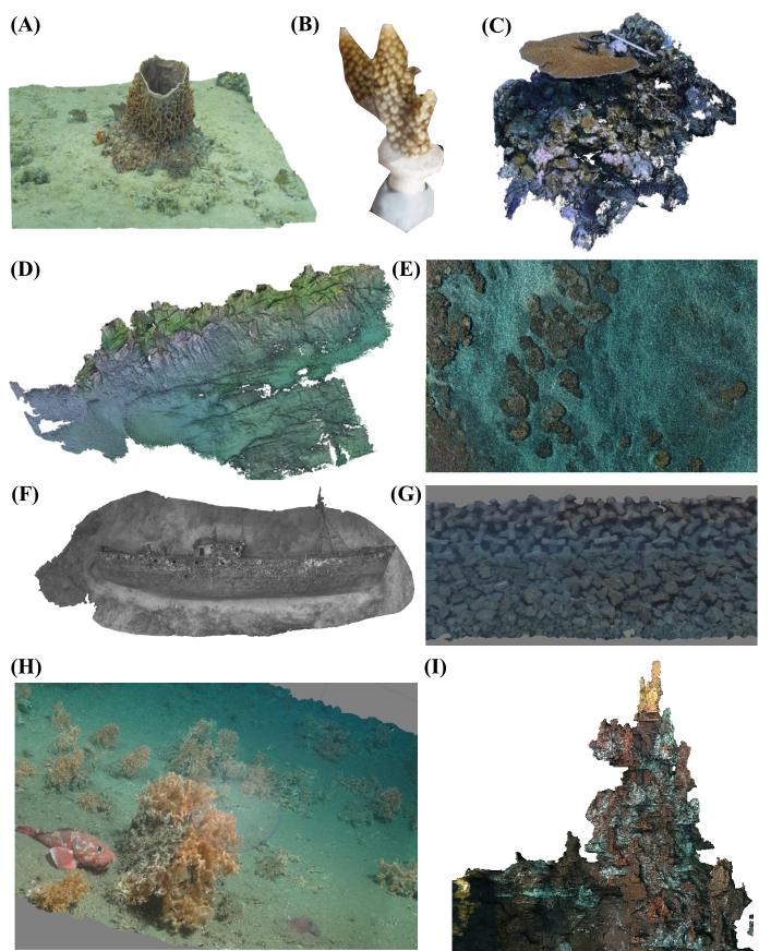
Diversity of photogrammetry models, acquisition methods and applications presented during the workshop. (A) 3D model of Xestospongia testudinaria from scuba diving - Mozambique (2020) © Creocean; (B) Acropora sp coral nubbin 3D model for temporal survey. © Urbina-Barreto I. Future Maore Reefs project - French National Institute for Sustainable Development (IRD); (C) Coral reef model in Mayotte underwater photogrammetry, artistic and awareness actions. © Urbina-Barreto I. Future Maore Reefs project & Simon R. CORAUX project. French National Institute for Sustainable Development (IRD) & OFB Natural Marine Parc of Mayotte; (D) 3D model of the seabed geomorphology at the Dellec shoreline in the French Brittany using the Poseidon floating platform © TELEMAC project; (E) coral reef photograph acquired with an unmanned aerial vehicle - Belizes © National Oceanography Centre; (F) 3D model of Antonio Lorenzo wreck from scuba diving - La Reunion (2017) © Geolab – Comité de plongée Réunion; (G) Inspection of submerged structures for coastal road construction - Reunion Island. © Urbina-Barreto I. PhD thesis (2020); (H) 3D model of a cold-water coral reef imaged with the remotely operated vehicle Isis - Whittard Canyon, -850 m (2015) © JC125, National Oceanography Centre (I) 3D model of the > 10 m-high Capelinhos vent edifice with the remotely operated vehcle Victor6000 - Lucky Strike vent field, -1665 m (2020) © MoMARSAT 2020, IFREMER. All pictures have been reused under CC by 4.0.